This item has been sold, but you can get on the Waitlist to be notified if another example becomes available, or purchase a digital scan.
1909 MacCoun Map of Manhattan, New York, in 1609 w/ Indian Tribes
Manhattan-maccoun-1909$625.00

Title
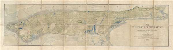
1609 The Island of Manhattan (Mannahtin) At the Time of its Discovery Showing its Elevations, Water-Courses, and Shore Line.
1909 (dated) 13 x 49 in (33.02 x 124.46 cm) 1 : 22000
1909 (dated) 13 x 49 in (33.02 x 124.46 cm) 1 : 22000
Description
A very rare map of the island of Manhattan, New York City, as is presumably appeared in 1609, shortly after the Dutch began settling the island. This map was issued by Townsend MacCoun and is base, cartographically, on the great 1867 survey of Egbert Viele, which it follows almost exactly. To this geography, MacCoun has added, in red, the site of various American Indian villages, as well as the American Indian name of several Manhattan rivers and inlets.
The Viele Map, which was first issued in 1865 provides the basic groundwork for this smaller and more modern map. Egbert L. Viele's 1865 topography and waterways map of Manhattan, one of the scarcest, most important and most enduring maps of New York City ever published. Covering the entirety of Manhattan Island, Viele's map details the canals, swamps, rivers, ditches, ponds, meadows, and drainage basins of Manhattan as they existed prior to the city's urban development. A version of the Viele map remains in use today by architects and contractors who need to be certain they are not building over underground rivers and swamps that may destabilize a new construction's foundation.
Roughly translated 'Manhattan' is an American Indian term meaning 'Island of Hills'. The American Indians living in the region prior to the Dutch settlement of Manhattan treated the island as a huge hunting and fishing reserve full of trout streams, bass swamps, and sunfish ponds. Viele contended that as streets and buildings were constructed the city's natural drainage retreated underground where, stagnating, it led to a 'humid miasmic state of the atmosphere' conducive to yellow fever, malaria, plague, and other epidemic illnesses.
Viele dedicated nearly 20 years to researching and perfecting a masterpiece of cartography. The basic map and above ground topography of the Viele map is drawn from John Randel's surveys of 1807 and the Commissioner's Plan of 1811, which formally laid out New York City's grid system. Viele then used early survey work, new survey work, and studies of older maps to recreate Manhattan's water system as it must have existed when the first Dutch settlers built a fur trading post of the tip of the island. Viele presented an unfinished early state of his map, covering only lower Manhattan to the New York State Senate in 1859, claiming,
This specific map, heir to the Viele map of 1865, was issued by MacCoun as part of series of separate issue maps entitled, collectively, Early New York History, Portrayed in Five Maps MacCoun composed which focused on early New York city. Of the series of five maps, this is the largest and most impressive. The series in general is quite rare, with the New York Public Library in possession of only 3 of the 5.
It was engraved by L. L. Poates, of New York City and in printed in three colors. The whole has been dissected and mounted on linen. This map was legally deaccessioned from the Public Library of Kansas City, Missouri, whose stamp appears in the upper right.
The Viele Map, which was first issued in 1865 provides the basic groundwork for this smaller and more modern map. Egbert L. Viele's 1865 topography and waterways map of Manhattan, one of the scarcest, most important and most enduring maps of New York City ever published. Covering the entirety of Manhattan Island, Viele's map details the canals, swamps, rivers, ditches, ponds, meadows, and drainage basins of Manhattan as they existed prior to the city's urban development. A version of the Viele map remains in use today by architects and contractors who need to be certain they are not building over underground rivers and swamps that may destabilize a new construction's foundation.
Roughly translated 'Manhattan' is an American Indian term meaning 'Island of Hills'. The American Indians living in the region prior to the Dutch settlement of Manhattan treated the island as a huge hunting and fishing reserve full of trout streams, bass swamps, and sunfish ponds. Viele contended that as streets and buildings were constructed the city's natural drainage retreated underground where, stagnating, it led to a 'humid miasmic state of the atmosphere' conducive to yellow fever, malaria, plague, and other epidemic illnesses.
Viele dedicated nearly 20 years to researching and perfecting a masterpiece of cartography. The basic map and above ground topography of the Viele map is drawn from John Randel's surveys of 1807 and the Commissioner's Plan of 1811, which formally laid out New York City's grid system. Viele then used early survey work, new survey work, and studies of older maps to recreate Manhattan's water system as it must have existed when the first Dutch settlers built a fur trading post of the tip of the island. Viele presented an unfinished early state of his map, covering only lower Manhattan to the New York State Senate in 1859, claiming,
The sanitary condition of any city or district or country is intimately connected with its proper drainage . . . that any inquiry into causes or remedies for sanitary evils . . . shall be based upon a thorough knowledge of the topography of the island.It took another six years of meticulous study to produce the final product - an extraordinary achievement.
This specific map, heir to the Viele map of 1865, was issued by MacCoun as part of series of separate issue maps entitled, collectively, Early New York History, Portrayed in Five Maps MacCoun composed which focused on early New York city. Of the series of five maps, this is the largest and most impressive. The series in general is quite rare, with the New York Public Library in possession of only 3 of the 5.
It was engraved by L. L. Poates, of New York City and in printed in three colors. The whole has been dissected and mounted on linen. This map was legally deaccessioned from the Public Library of Kansas City, Missouri, whose stamp appears in the upper right.
Cartographer
Townsend MacCoun (1845 - September 10, 1932) was an American cartographer, publisher and historian active in the second half of the 19th and early 20th centuries. Townsend was born in Troy, New York, the son of John T. MacCoun and Angelica Rachel Douw (Lane) MacCoun. MacCoun attended Williams Collage, from which he was awarded degrees in 1866 and 1869. His composed several cultural and geographical works, including a history of the United States, another of the Holy Land, and a series of five historical maps of New York City. He also developed and proselytized employing a universal color coding system in all maps appearing in a single book or book series - a technique that remains in use today in many text books. He was a member of the Chi Psi Fraternity, the American Geographical Society, and the Paris Société Academique d'Histoire Internationale. More by this mapmaker...
Condition
Very good. Dissected and mounted on linen. Red printing marks near modern day city hall. Library date stamps lower right. Library stamp upper right. Legally deaccessioned.