This item has been sold, but you can get on the Waitlist to be notified if another example becomes available, or purchase a digital scan.
1955 National Air Map Company Aerial Photo Map of Manhattan
Manhattan-nationalairmapcompany-1955$500.00

Title
Aerial Photo Map of New York City.
1955 (undated) 30 x 90 in (76.2 x 228.6 cm) 1 : 9600
1955 (undated) 30 x 90 in (76.2 x 228.6 cm) 1 : 9600
Description
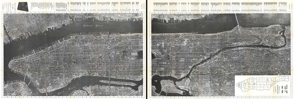
This is a c. 1955 National Air Map Company aerial photographic map of the borough of Manhattan in New York City. The map depicts the borough from Battery Park to the Harlem River and from the Hudson River to the East River, Brooklyn, Queens, and the Bronx. Highly detailed, individual buildings are recognizable throughout, including New York City landmarks such as the Metropolitan Museum of Art, the American Museum of Natural History, Rockefeller Center, Radio City Music Hall, Bryant Park and the central New York Public Library Building, and Grand Central Station, all of which are labeled. Several city landmarks are not labeled, including the Empire State Building, which is identifiable by its shadow, and the Guggenheim Museum with its iconic rotunda. Myriad streets are labeled, and the IND, BMT, and IRT subway lines are each illustrated using different notations. Individual docks on both sides of the Hudson River are labeled as well. A street index is situated along the top (or left) border, depending on how one orients the map, which also includes a list of museums and sport centers in the city.
How did we date this map?
As this map is undated, it proved to be a slight challenge to narrow down when it was printed. In the end we decided on c. 1955 based on the inclusion of the Triborough Stadium in the list of sport centers along the top margin. Triborough Stadium was known by that name from 1948 - 1955, and before that it was called Randall's Island Stadium. It was renamed Downing Stadium in 1955, and ultimately torn down in 2002 and replaced by Icahn Stadium.Publication History and Census
This map was created and published by the National Air Map Company c. 1955. The only known example resides in the collection at Columbia University.Condition
Very good. Light wear and toning along original fold lines. Light soiling. Verso repairs at fold intersections. Blank on verso.
References
OCLC 953204110.