This item has been sold, but you can get on the Waitlist to be notified if another example becomes available, or purchase a digital scan.
1953 Pacific Stars and Stripes Map of the Korean War
Mapofwar-pacific-1953$125.00

Title
Pacific Stars and Stripes Map of the War.
1953 (dated) 32 x 21.5 in (81.28 x 54.61 cm) 1 : 2300000
1953 (dated) 32 x 21.5 in (81.28 x 54.61 cm) 1 : 2300000
Description
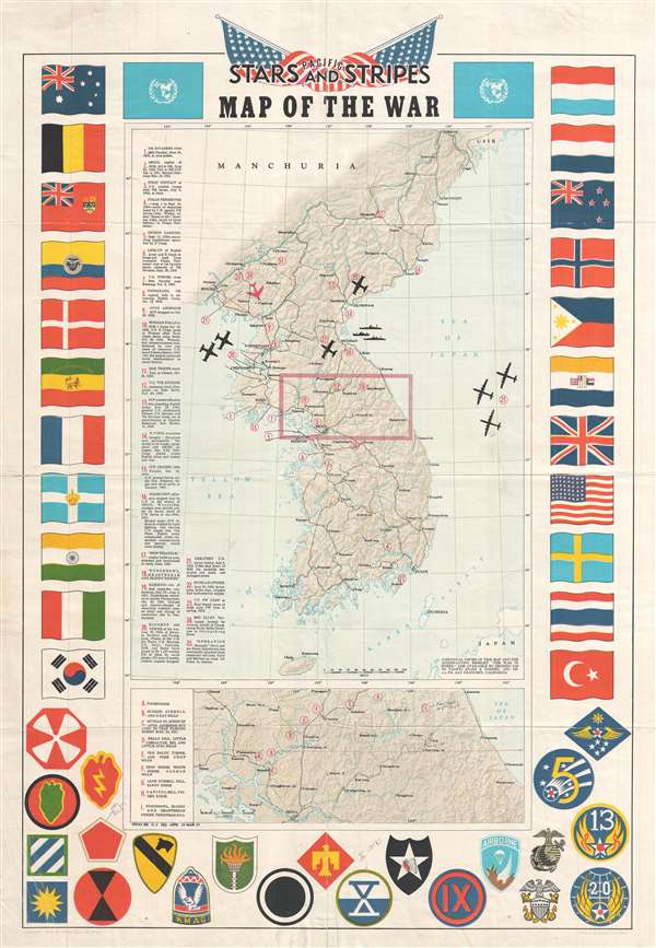
This is a 1953 Pacific Stars and Stripes map of the Korean War. The map depicts the Korean peninsula from the Yalu River and the Tumen River to the Korea Strait and from the Yellow Sea to the Sea of Japan. Twenty-five different events in the history of the Korean War are numerically identified, with explanations appearing along the left border. Several silhouettes of aircraft are depicted, including what appears to be the Grumman F9F Panther, a squadron of large four-engine bombers over the Sea of Japan, and a MiG-15 illustrated in red. An inset map, situated below the central map of the Korean peninsula, details the area in the box in the larger map, along the 38th parallel from Yonan and P'anmunjom to Kansong. Several different hills and ridges that played major roles in battles are labeled, including the area of the Punchbowl, Bloody Ridge, Heartbreak Ridge, and Christmas Hill. The map is bordered on three sides by the flags of the United Nations and the insignia of numerous American combat units are included along the bottom border.
Due to the presence of a signature on the verso, as well as other manuscript notations, it is plausible that this map belonged to a veteran of the Korean War. Sadly, the signature is not entirely legible, but the manuscript notations on the recto are. The insignia of the 5th Regimental Combat Team (R.C.T.) has been labeled, along with that of the X Corps. Two other manuscript notations are on the inset map. One labels the X Corps Rec. Center, near Inje and Pup'yong-ni. The other labels the Punchbowl – one of the most harrowing battles of the war – and presumably states that the writer had been there with the 5th R.C.T.
This map was published by Pacific Stars and Stripes in 1953 and printed by the Kyoya Company of Tokyo.
Cartographer
Stars and Stripes, Pacific Editions (1945-1963) began publishing the week of VE Day in May, 1945 in Honolulu, Hawaii. Later that year editions were published in China and Japan as well. When the war ended, the newspaper’s readership and staff both fell, although it was still published for occupational forces and other armed forces still employed. In 1951, during the Korean War, a Korean edition was published. More by this mapmaker...
Condition
Good. Wear along original fold lines. Even overall toning. Light soiling. Verso repairs to fold separations. Closed margin tears professionally repaired on verso. Blank on verso
References
OCLC 953572675. Rumsey 7848.000.