This item has been sold, but you can get on the Waitlist to be notified if another example becomes available, or purchase a digital scan.
1825 Berthe Map of the World in Two Hemispheres
Mappemonde-berthe-1826$600.00


Title
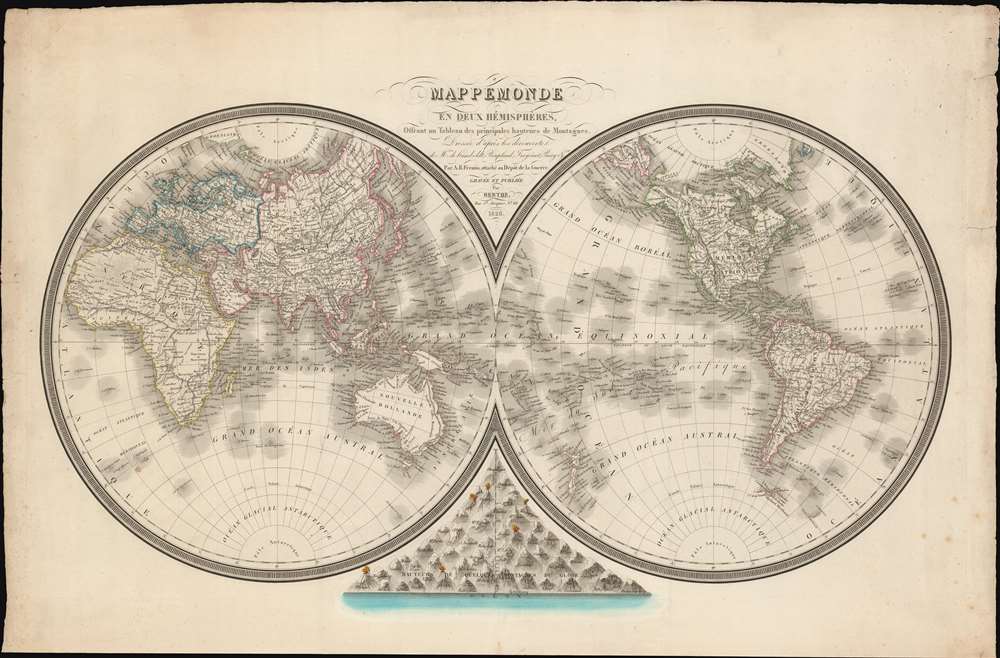
Mappemonde en Deux Hémisphères, Offrant un Tableau des Principales Hauteurs de Montagnes.
1826 (dated) 21 x 33 in (53.34 x 83.82 cm) 1 : 60000000
1826 (dated) 21 x 33 in (53.34 x 83.82 cm) 1 : 60000000
Description
A dramatic separately-published French 1826 double-hemisphere map of the world by L. M. Berthe and A. R. Fremin. The map includes a bizzare and ephemeral treatment of the Pacific Northwest integrating the fictional discoveries of Maldonado (Kiteguen and Kioumi) and de Fonte (Valasco). It is further striking for its comparative Mountains chart at bottom center.
Struggling with the Pacific Northwest - StillDespite the remarkable explorations of Cook, Vancouver, La Perouse, and Parry - and the many accurate maps they produced, the American Arctic, particularly the Pacific Northwest, remained an intractable mystery to cartographers. Here, factual discoveries struggle for reconciliation with debunked legends and the persistent hope for a practical northwest passage.An Inland River RouteThe Great Slave Lake, discovered by Samuel Hearne in 1771, and visited again by John Franklin in 1823, is here connected via the Chesterfield Inlet to the Hudson Bay on the east, to the Arctic Ocean via the factual Mackenzie River, and to the Pacivia via the fictional 'R. de los Reyes' and 'L. Belle'.
Maldanado claimed to have traversed the passage in 1588, a voyage he recounts in his Relación del descubrimiento del Estrecho de Anian. The Relación was presented to the Spanish crown and circulated in manuscript, but remained little-known and unpublished until 1788. Two years later, in 1790, the Relación caught the attention of the positivist cartographer Jean-Nicholas Buache de Neuville (1741 - 1825), whose used it to support his own geographic speculations in a paper presented at the Paris Académie des Sciences. The influence of the Académie was such that Spain tasked the Malaspina Expedition (1789 - 1794) to determine the truth of the matter. In the wake of the Relación's resurgence in scientific circles, it was republished in 1811 and again in 1812, drawing general attention. Maldonado was widely discredited in 1849 by Fernandez Navarrete.
The tale of De Fonte' discoveries in the American Northwest had an enduring influence on cartographic representations of America through the second half of the 18th century and early 19th century. The De Fonte legend first appeared in a 1706 English publication entitled Memoirs of the Curious. This short-lived magazine published a previously unknown account by a supposed Spanish Admiral, Bartholomew de Fonte. De Fonte reportedly sailed up the Pacific Coast of North America in 1640. On this voyage, he reports discovering a series of gigantic lakes, seas, and rivers heading eastward from the Pacific towards Hudson Bay. The De Fonte story relates how, on one of these inland lakes, he met with a westward bound ship from Boston that must have come through the Northwest Passage. At the same time, De Fonte sent one of his sub-captains, Pedro Bernarda, northward to explore a 'beautiful river with deep calm waters.' This sub-exploration led to the discoveries of Lake Valasco, R. Bernarda, and Lac Bernarda - as seen here. Today, based upon inaccuracies and falsities, most believe the entire De Fonte legend to have been a fabrication. Nonetheless, it set 18th century Europe afire with speculation. Even such luminaries as Benjamin Franklin wrote emphatic defenses of De Fonte.
Struggling with the Pacific Northwest - StillDespite the remarkable explorations of Cook, Vancouver, La Perouse, and Parry - and the many accurate maps they produced, the American Arctic, particularly the Pacific Northwest, remained an intractable mystery to cartographers. Here, factual discoveries struggle for reconciliation with debunked legends and the persistent hope for a practical northwest passage.An Inland River RouteThe Great Slave Lake, discovered by Samuel Hearne in 1771, and visited again by John Franklin in 1823, is here connected via the Chesterfield Inlet to the Hudson Bay on the east, to the Arctic Ocean via the factual Mackenzie River, and to the Pacivia via the fictional 'R. de los Reyes' and 'L. Belle'.
The True Northwest Passage - but not then
An alternative northwest passage extends from the Fox Canal and Melville Peninsula through the Strait of Hecla (Fury and Hecla Strait) in the 'Mer Polaire'. The cartographer correctly recognizes sighting of the Polar Sea at the mouth of the Coppermine and Mackenzie Rivers, but fails to account for the fact that 'Nord Somerset' was for all intent and purposes a peninsula (it's an island, but at the time, all passages where perpetually frozen). So, the only access to this 'sea' would be via the Strait of Barrow, north of Cumberland Island. Following this passage, one could in theory reach the Barrow Sea north of Alaska, and thence the Bering Strait, but in general, this route was impractical and closed - at least until global warming did its magic in the 20th century.Kiteguen and Kioumi
This is one of only a few maps to include the geography of the Spanish adventurer Lorenzo Ferrer Maldonado (c. 1550 - 1625) - here represented by the fictional lands he 'discovered', Kiteguen and Kioumi, stretching across the Arctic from the Bering Strait to Greenland. Kiteguen was supposedly a continent sized landmass attached to Greenland, thus sheltering an inland sea, Mer Polaire, from the polar ice creating a navigable passage from Atlantic to Pacific.Maldanado claimed to have traversed the passage in 1588, a voyage he recounts in his Relación del descubrimiento del Estrecho de Anian. The Relación was presented to the Spanish crown and circulated in manuscript, but remained little-known and unpublished until 1788. Two years later, in 1790, the Relación caught the attention of the positivist cartographer Jean-Nicholas Buache de Neuville (1741 - 1825), whose used it to support his own geographic speculations in a paper presented at the Paris Académie des Sciences. The influence of the Académie was such that Spain tasked the Malaspina Expedition (1789 - 1794) to determine the truth of the matter. In the wake of the Relación's resurgence in scientific circles, it was republished in 1811 and again in 1812, drawing general attention. Maldonado was widely discredited in 1849 by Fernandez Navarrete.
Kiteguen and De Fonte
On the present map, the cartographer uses the presumption of Kiteguen to validate the apocryphal De Fonte discoveries in the face of Mackenzie and Herne's sighting of the Polar Sea. These include 'Lac Valasco' and 'Lac Bernalda' (Bernarda) and an inland river system connecting them to the inter-coastal waterways near Sitka (Alaska).The tale of De Fonte' discoveries in the American Northwest had an enduring influence on cartographic representations of America through the second half of the 18th century and early 19th century. The De Fonte legend first appeared in a 1706 English publication entitled Memoirs of the Curious. This short-lived magazine published a previously unknown account by a supposed Spanish Admiral, Bartholomew de Fonte. De Fonte reportedly sailed up the Pacific Coast of North America in 1640. On this voyage, he reports discovering a series of gigantic lakes, seas, and rivers heading eastward from the Pacific towards Hudson Bay. The De Fonte story relates how, on one of these inland lakes, he met with a westward bound ship from Boston that must have come through the Northwest Passage. At the same time, De Fonte sent one of his sub-captains, Pedro Bernarda, northward to explore a 'beautiful river with deep calm waters.' This sub-exploration led to the discoveries of Lake Valasco, R. Bernarda, and Lac Bernarda - as seen here. Today, based upon inaccuracies and falsities, most believe the entire De Fonte legend to have been a fabrication. Nonetheless, it set 18th century Europe afire with speculation. Even such luminaries as Benjamin Franklin wrote emphatic defenses of De Fonte.
Publication History and Census
This map was prepared and engraved in Paris by L. M. Berthe and published by A. R. Fremin in 1826. It is listed in the Bibliograpie de la France journal for April of 1826 as a separate issue, available colored (as here) for 4 Francs or uncolored for 3 Francs. The map is today quite scarce. We note just two other examples, one at the Bibliothèque nationale de France and another at the Muséum national d'histoire naturelle.CartographerS
L. H. Berthe (fl. c. 1777 - 1830) was a French engraver active in Paris in the early to mid-19th century. Little is known of Berthe. He seems to have been active as early as 1777 and as late as 1830. He maintained offices at Rue St. Jacques , No. 66. More by this mapmaker...
A. R. Fremin (fl. c. 1810 - c. 1860) was a French geographer active in the early to mid 19th century. He is known to have been a student of the cartographer Jean-Baptiste Poirson. Fremin drew and compiled maps for many prominent French cartographic publishers of the period including Tardieu, Logerot, Dufour, Monin, Duvotenay, Dyonnet, and Vuillemin. Little else is known of Fremin's life and work. Learn More...
Depot de Guerre (1688 - 1887) was a branch of the French military devoted to creating, collecting, and publishing military memoirs, plans, and maps. The Depot was founded in 1688 by Francois Michel le Tellier, the Marquis de Louvois. Louvois held the post of Secretary of State for War under Louis XIV and his best known for composing the first letter regarding the mysterious "Man in the Iron Mask". During the French Revolution and the Napoleonic Wars the Depot de Guerre expanded its operations to include any and all topographical research in France. In 1887 the Depot de Guerre was disbanded and its duties split between the Institut Geographique National (IGN) and the Service Historique de L'Armee (SHA). Learn More...
Condition
Very good. Some edge wear. A few of minor closed and stabilized margin tears.
References
Bibliothèque nationale de France, département Cartes et plans, GE C-6174. OCLC 801056048.