This item has been sold, but you can get on the Waitlist to be notified if another example becomes available, or purchase a digital scan.
1905 Graham Map of the Philippine Islands
MapPhilippines-bureauinsular-1905$375.00

Title
Map of the Philippines.
1905 (dated) 46 x 26 in (116.84 x 66.04 cm) 1 : 1250000
1905 (dated) 46 x 26 in (116.84 x 66.04 cm) 1 : 1250000
Description
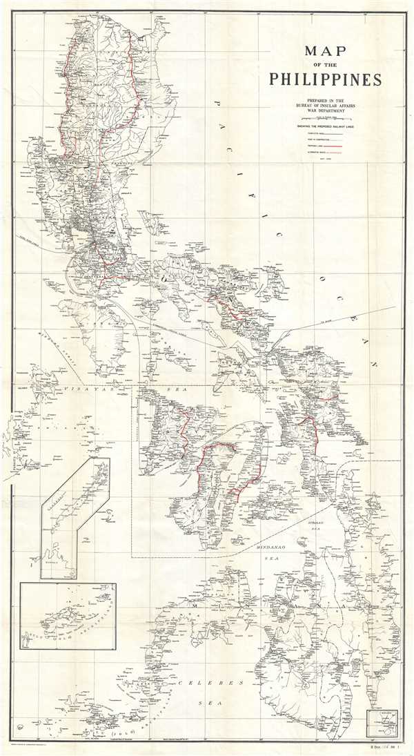
A scarce and impressive large format map of the Philippines issued in 1905 to illustrate proposed rail lines. In 1905 the Second Philippine Commission, under William H. Taft, put forth a request for bids to build a series of modern railway lines between important cities in the Philippines. This map was prepared to illustrate the proposals those received from various private companies. In total, 11 proposals are represented, some with alternative and branching routes. Most were eventually constructed and integrated into the limited existing Spanish Era rail lines. This map is accompanied by the original government report describing the bids.
Although the presently offered map is very large, it is based upon another map, nearly twice as large, issued by Andrew B. Graham in 1902. The Graham imprint remains in the bottom left hand corner of the map. Graham's map expresses little in the way of topography, but riverways, cities, and political boundaries are identified. Proposed railroad lines are defined in red.
Although the presently offered map is very large, it is based upon another map, nearly twice as large, issued by Andrew B. Graham in 1902. The Graham imprint remains in the bottom left hand corner of the map. Graham's map expresses little in the way of topography, but riverways, cities, and political boundaries are identified. Proposed railroad lines are defined in red.
Cartographer
Andrew B. Graham (1845 - September 9, 1909) was an American lithographer active in Washington, D.C. in late 19th and early 20th century. Graham was born in Washington D.C., the son of a lithographer and engraver. After college, he joined the U.S. Coast Survey, where he was a draftsman until 1889. He retired from the Coast Survey to take over management of his father's lithography firm. The firm, Andrew B. Graham Company, was one of several that thrived on lucrative government publication contracts. Graham died of 'brain fever' in his Washington D. C. residence on September 9 of 1909. Some of his work was republished posthumously until about 1917, and his firm was active until at least the early 1920s. More by this mapmaker...
Condition
Very good. Professionally flattened and lined with archival tissue. Minor wear along original fold lines. Minor foxing.