
Graham, Andrew B.

Andrew B. Graham (1845 - September 9, 1909) was an American lithographer active in Washington, D.C. in late 19th and early 20th century. Graham was born in Washington D.C., the son of a lithographer and engraver. After college, he joined the U.S. Coast Survey, where he was a draftsman until 1889. He retired from the Coast Survey to take over management of his father's lithography firm. The firm, Andrew B. Graham Company, was one of several that thrived on lucrative government publication contracts. Graham died of 'brain fever' in his Washington D. C. residence on September 9 of 1909. Some of his work was republished posthumously until about 1917, and his firm was active until at least the early 1920s.
Spanish-Era Land Grants in New Mexico.
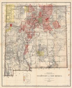
Territory of New Mexico.
$1,200.00
Acquire
- Digital Map Information
- Suitable for large format printing
- File Size: 233.72 MB
- File Type: ZIP / TIFF
- ICC color profile embedded
- Delivered instantly via download link
This is a large and detailed 1896 Robert H. Morton and General Land Office map of the New Mexico Territory. The map highlights private land grants, American Indian reservations, military bases, and forest reserves. Of greatest interest are the illustrated land grants, including the Tierra Amarilla Grant, the Beaubien and Miranda Grant, and the Mora Grant. Other annotations represent private grants that required new boundary surveys, were unconfirmed, or that had been rejected or dismissed by the U.S. government. Yellow areas represent reservations granted to the Jicarilla Apache, the Navajo, the Southern Ute, the Zuni, and the Mescalero Apache. (more details)
Central Luzon issued during the Philippine-American War.
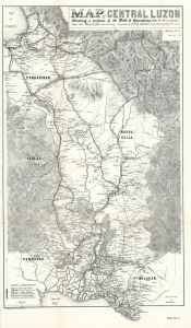
Map of Central Luzon showing a portion of the Field of Operations of the 8th Army Corps.
$850.00
Acquire
- Digital Map Information
- Suitable for large format printing
- File Size: 29.91 MB
- File Type: ZIP / TIFF
- ICC color profile embedded
- Delivered instantly via download link
This is a rare map of central Luzon, the Philippines, issued at the height of the Philippine-American War (1899 - 1902) by William L. Sibert of the 8th Army Engineering Corps and the Military Governor in the Philippines, Major General Elwell Stephen Otis. This map is one of the most detailed cartographic productions from the Philippine-American War. (more details)
Largest and Best Map of Puerto Rico during Spanish-American War.
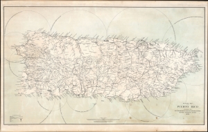
Outline Map of Puerto Rico.
$950.00
Acquire
- Digital Map Information
- Suitable for large format printing
- File Size: 94.92 MB
- File Type: ZIP / TIFF
- ICC color profile embedded
- Delivered instantly via download link
A remarkable 1899 wall map of Puerto Rico printed shortly after the island's annexation at the end of the Spanish-American War (April 21, 1898 - August 13, 1898). The map is derived from the U.S. Army General Staff Map, used to plan American military action in Puerto Rico. It was also the largest and best map of the island produced to date. Like the General Staff Map, this chart is incomplete, with some areas exhibiting only the most spartan cartographic detail. (more details)
The first major telegraph lines throughout the Philippines.
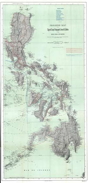
Progress Map of Signal Corps Telegraph Lines and Cables in the Military Division of the Philippines.
$900.00
Acquire
- Digital Map Information
- Suitable for large format printing
- File Size: 51.28 MB
- File Type: ZIP / TIFF
- ICC color profile embedded
- Delivered instantly via download link
This is a scarce 1900 map of the Philippines prepared under the direction of General Adolphus Washington Greely. This map represents a major step forward in Philippine infrastructure. The map is large and comprehensive, extending from the Babuyan Islands to the Sulu Archipelago, encompassing most of the modern-day Philippines except for Palawan. Cartographically, it is derived from the 1870 work of Claudio Montero y Gay. The map exhibits limited depth soundings throughout, but particularly between major island groups. American telegraphic cables, both extent and projected, are highlighted in red, while British lines appear in blue. (more details)
Luzon during the Philippine-American War.
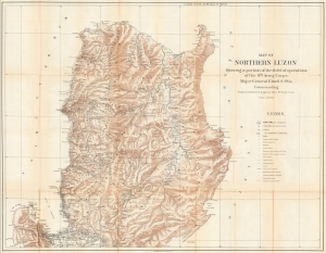
Map of Northern Luzon Showing a portion of the field operations of the 8th Army Corps, Major General Elwell S. Otis Commanding.
$950.00
Acquire
- Digital Map Information
- Suitable for large format printing
- File Size: 66.74 MB
- File Type: ZIP / TIFF
- ICC color profile embedded
- Delivered instantly via download link
This is a rare map of Northern Luzon, the Philippines, issued in 1900 at the height of the Philippine-American War (1899 - 1902) by the Military Governor in the Philippines, Major General Elwell Stephen Otis, and the 8th Army Engineering Corps. This map is one of the largest and most detailed cartographic productions from the Philippine-American War. (more details)
Southern (Central) Luzon during the Philippine-American War.
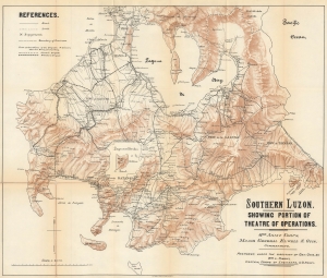
Southern Luzon. Showing Portion of Theater of Operations. 8th Army Corps, Major General Elwell S. Otis, Commanding.
$950.00
Acquire
- Digital Map Information
- Suitable for large format printing
- File Size: 31.67 MB
- File Type: ZIP / TIFF
- ICC color profile embedded
- Delivered instantly via download link
This is a scare map of Central Luzon, the Philippines, issued at the height of the Philippine-American War (1899 - 1902) by the Military Governor in the Philippines, Major General Elwell Stephen Otis, and the 8th Army Engineering Corps. It ranks among the most detailed cartographic productions from the Philippine-American War. (more details)
Lanai's traditional Hawaiian land subdivisions.
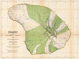
Lanai.
$850.00
Acquire
- Digital Map Information
- Suitable for large format printing
- File Size: 56.56 MB
- File Type: ZIP / TIFF
- ICC color profile embedded
- Delivered instantly via download link
This is the 1878 / 1906 Hawaiian Government Survey and Hawaiian Territorial Survey map of Lanai, Hawaiian Islands. Jacob Brown and Marcus Monsarrat produced this detailed survey of Lanai in 1878, publishing at that time the preliminary version of the present map, the first to correctly capture Lanai's form. Today Lanai is the smallest publicly accessible inhabited island. Here, Lanai's ahupua'a, traditional land subdivisions, stretch across the island. The few roads are illustrated, along with a handful of foot trails. (more details)
First map of Niihau from a scientific survey.
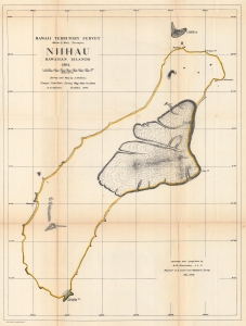
Hawaii Territorial Survey. Niihau Hawaiian Islands.
$350.00
Acquire
- Digital Map Information
- Suitable for large format printing
- File Size: 42.62 MB
- File Type: ZIP / TIFF
- ICC color profile embedded
- Delivered instantly via download link
The most accurate map of the island up to that time, this is the 1906 Kerns and Newton map of Niihau, Hawaiian Islands. The map is based on the 1903 Samuel M. Kerns survey, consigned to print in 1906 by Herbert E. Newton. It marks points, bays, and other coastal features. The lava fields around Puulua, Kaleo, and Paniau are illustrated. The elevation of Kawaihoa Point, on the southern tip of the island, is provided as well. (more details)