This item has been sold, but you can get on the Waitlist to be notified if another example becomes available, or purchase a digital scan.
1893 Bartlett Map of Massachusetts Public Schools
MAPublicSchools-bartlett-1893$475.00

Title
The Public Schools of Massachusetts.
1893 (undated) 17.25 x 27 in (43.815 x 68.58 cm) 1 : 480000
1893 (undated) 17.25 x 27 in (43.815 x 68.58 cm) 1 : 480000
Description
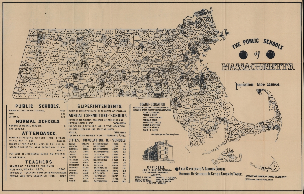
This is an 1893 George H. Bartlett map of Massachusetts Common Schools representing the pioneering of American public education in Massachusetts. The common schools mapped here were community-organized public schools with a religious underpinning. They predated the state-funded public school system we know today. This map focuses on the final years of the common school system and pioneering efforts in Massachusetts to centralize and 'normalize' public education under the state banner. Massachusetts was the first state to do so, thus this map documents the developmental stages of public education as we know it today.
Horace Mann became the Secretary of the Massachusetts State Board of Education in 1837 and served until 1848. During these years, Mann sought to create a universal standard for public education, which then varied from region to region, if not community to community. In 1839, Mann also opened the first 'normal school' for training teachers in the belief that a uniform educator baseline would help standardize education across the state. The close relationship with Protestantism did not go unchallenged, particularly by immigrants, some of whom, including Catholics in Philadelphia, founded their parochial schools. Common schools spread across the United States throughout the latter half of the 19th century, but education scholars see the common school era as ending around 1900, when schools were reorganized into school districts with state and federal funding, under state supervision.
A Closer Look
City and town boundaries throughout are illustrated. Black dots within each represent common schools. Some towns boast over a dozen, while others lack any. Statistics in the lower left detail the number of public schools, normal schools (which train teachers), teachers, superintendents, attendance information, annual expenditure, and the population and number of schools in some thirty cities.Common Schools
Common schools were a religion-focused community-funded public school that rose to prominence in the 19th century, particularly in New England. They were an outgrowth of the First and Second Great Awakenings, periods of mass Protestant revival in Britain and America that called for everyone to be educated so that they could read the Bible. In the mid-19th century, common schools were promoted by Horace Mann (1796 - 1859), an outspoken advocate for public education. Typically, common schools institutionalized religion into the curriculum, particularly Puritan teachings, with catechisms as grammar books and local clergy as educators.Horace Mann became the Secretary of the Massachusetts State Board of Education in 1837 and served until 1848. During these years, Mann sought to create a universal standard for public education, which then varied from region to region, if not community to community. In 1839, Mann also opened the first 'normal school' for training teachers in the belief that a uniform educator baseline would help standardize education across the state. The close relationship with Protestantism did not go unchallenged, particularly by immigrants, some of whom, including Catholics in Philadelphia, founded their parochial schools. Common schools spread across the United States throughout the latter half of the 19th century, but education scholars see the common school era as ending around 1900, when schools were reorganized into school districts with state and federal funding, under state supervision.
Publication History and Census
This map was 'designed and drawn by George H. Bartlett' and published in 1893. We note three examples cataloged in OCLC: Brown University, the State Library of Massachusetts, and the Newberry Library. We note an additional example at the Norman B. Leventhal Map Center at the Boston Public Library.Cartographer
George Hartnell Bartlett (May 24, 1838 - March 26, 1923) was an English lithographer active in Westminster, London, New York City, and Boston and is best known for his architectural diagrams. Bartlett was born in Camberwell, London, England. He studied engineering. He also mastered printing and lithography, pioneering the Steam Press in London, c. 1867. In that year, he published a pictorial or 'monumental-style' map of London, somewhat pioneering at the time, which included his own illustrations of important buildings and monuments. In May 1870, he relocated to New York City. There he immediately established himself at 309 Broadway where he partnered with 'Major and Knapp' to publish a similar pictorial map of New York. By 1871, we find him in Boston, where, while visiting, he applied for a teaching position on a whim, and earning the position, remained in Boston. There in 1871 he published a similar map of that city. He also issued a somewhat related map, in 1893, illustrating the Public Libraries of Massachusetts (another edition in 1904). He remained in Boston for the remainder of his career, establishing himself as a leading member of the Boston Lithographic Artists’ Association and from 1883 - 1912 he served as Principal of the Massachusetts State Normal Art School. During this time, he published a well-regarded test on pen and ink drawing. Bartlett applied for U.S. Citizenship in 1883 and was naturalized as a U.S. Citizen on October 24, 1887. His name is sometimes misprinted in sources as 'C. H. Bartlett.' He died at his home in Arlington, Massachusetts, in 1923. More by this mapmaker...
Condition
Very good. Light wear along original fold lines. Fold separation along top margin.
References
Boston Public Library, Leventhal Map Center G3761.E68 1893 .B37. OCLC 60426210.