This item has been sold, but you can get on the Waitlist to be notified if another example becomes available, or purchase a digital scan.
1829 Thomson Map of the Marches of Alexander the Great (Middle East, Asia)
MarchesofAlexander-thomson-1829$250.00

Title
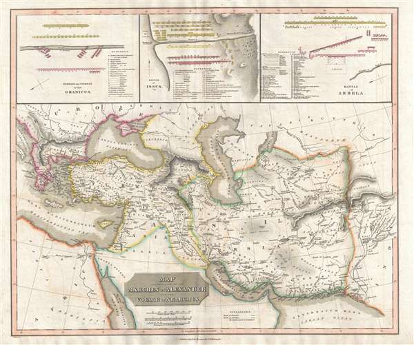
Map Illustrative of the Marches of Alexander and the Voyage of Nearchus
1829 (dated) 20.5 x 24 in (52.07 x 60.96 cm) 1 : 9100000
1829 (dated) 20.5 x 24 in (52.07 x 60.96 cm) 1 : 9100000
Description
A rare 1829 John Thomson historical map illustrating the Battles and Marches of Alexander the Great. Centered on the Caspian Sea, the map cover from the Adriatic Sea to Indus River Valley and from Crimea to the Red Sea, including all of the modern day Middle East, as well as Persia (Iran), Afghanistan, Turkey, northern Arabia, Israel / Palestine, Syria, Jordan, Greece, the Caucuses, etc. Route markings show both the marches of Alexander the Great into Persia as well as the voyage of Nearchus, a Navarch (Admiral) under Alexander the Great, from the Indus River to the Persian Gulf. Additional routes noted include the March of Hephestion and the March of Craterus. At the top of the map, three additional maps detail strategies employed by Alexander at three historic battles: The Granicus, Issus, and Arbela (Battle of Gaugamela).
This map was published by James Wyld and John Thomson for Thomson's 1829 New Classical and Historical Atlas. This atlas, and the maps it contains, is quite rare as the OCLC identifies only 3 examples. James Wyld's imprint appears in the lower left making this an exceptionally early example of his work.
This map was published by James Wyld and John Thomson for Thomson's 1829 New Classical and Historical Atlas. This atlas, and the maps it contains, is quite rare as the OCLC identifies only 3 examples. James Wyld's imprint appears in the lower left making this an exceptionally early example of his work.
CartographerS
John Thomson (1777 - c. 1841) was a Scottish cartographer, publisher, and bookbinder active in Edinburgh during the early part of the 19th century. Thomson apprenticed under Edinburgh bookbinder Robert Alison. After his apprenticeship, he briefly went into business with Abraham Thomson. Later, the two parted ways, John Thomson segueing into maps and Abraham Thomson taking over the bookbinding portion of the business. Thomson is generally one of the leading publishers in the Edinburgh school of cartography, which flourished from roughly 1800 to 1830. Thomson and his contemporaries (Pinkerton and Cary) redefined European cartography by abandoning typical 18th-century decorative elements such as elaborate title cartouches and fantastic beasts in favor of detail and accuracy. Thomson's principle works include Thomson's New General Atlas, published from 1814 to 1821, the New Classical and Historical Atlas of 1829, and his 1830 Atlas of Scotland. The Atlas of Scotland, a work of groundbreaking detail and dedication, would eventually bankrupt the Thomson firm in 1830, at which time their plates were sequestered by the court. The firm partially recovered in the subsequent year, allowing Thomson to reclaim his printing plates in 1831, but filed again for bankruptcy in 1835, at which time most of his printing plates were sold to A. K. Johnston and Company. There is some suggestion that he continued to work as a bookbinder until 1841. Today, Thomson maps are becoming increasingly rare as they are highly admired for their impressive size, vivid hand coloration, and superb detail. More by this mapmaker...
Wyld (1823 - 1893) was a British publishing firm active throughout the 19th century. It was operated by James Wyld I (1790 - 1836) and his son James Wyld II (November 20, 1812 - 1887) were the principles of an English mapmaking dynasty active in London during much of the 19th century. The elder Wyld was a map publisher under William Faden (1749 - 1836) and did considerable work on the Ordinance Survey. On Faden's retirement in 1823, Wyld took over Faden's workshop, acquiring many of his plates. Wyld's work can often be distinguished from his son's maps through his imprint, which he signed as 'Successor to Faden'. Following in his father's footsteps, the younger Wyld joined the Royal Geographical Society in 1830 at the tender age of 18. When his father died in 1836, James Wyld II was prepared to fully take over and expand his father's considerable cartographic enterprise. Like his father and Faden, Wyld II held the title of official Geographer to the Crown, in this case, Queen Victoria. In 1852, he moved operations from William Faden's old office at Charing Cross East (1837 - 1852) to a new, larger space at 475 Strand. Wyld II also chose to remove Faden's name from all of his updated map plates. Wyld II continued to update and republish both his father's work and the work of William Faden well into the late 1880s. One of Wyld's most eccentric and notable achievements is his 1851 construction of a globe 19 meters (60 feet) in diameter in the heart of Leicester Square, London. In the 1840s, Wyld also embarked upon a political career, being elected to parliament in 1847 and again in 1857. He died in 1887 following a prolific and distinguished career. After Wyld II's death, the family business was briefly taken over by James John Cooper Wyld (1844 - 1907), his son, who ran it from 1887 to 1893 before selling the business to Edward Stanford. All three Wylds are notable for producing, in addition to their atlas maps, short-run maps expounding upon important historical events - illustrating history as it was happening - among them are maps related to the California Gold Rush, the New South Wales Gold Rush, the Scramble for Africa, the Oregon Question, and more. Learn More...
Source
Thomson, J. New Classical and Historical Atlas, (Edinburgh) 1829.
The New Classical and Historical Atlas is one of John Thomson's rarer works. The atlas was issued in concert with James Wyld and follows stylistically on Thomson's better known work from the New General Atlas. It was published in 1829 and contained 49 hand colored imperial folio maps. When it was originally issued the atlas cost a whopping 8 guinea. This atlas, though grand, must not have been exceptionally popular as Thomson was driven into bankruptcy one year later in 1830. Sales may have subsequently increased as his finances appear to have marginally recovered only to slump again in a second bankruptcy filing in 1835. Around this time Thomson sold the plates of this Classical Atlas to A. K Johnston. There is some evidence that Johnston considered republishing it from the original Thomson plates in 1835, but no full examples of this work survive.
Condition
Very good. Light transferrence. Original centerfold exhibits some wear.