1785 Tardieu / Crevecoeur Map of Martha's Vineyard, Massachusetts
MarthasVineyard-tardieu-1785-2$1,650.00
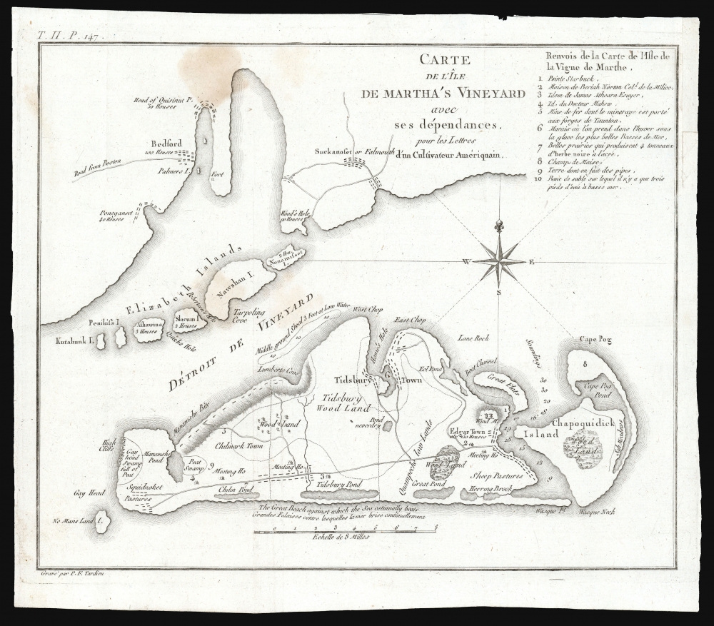

Title
Carte de L'Ile de Martha's Vineyard avec ses dependances, pour les Lettres d'un Culuvateur Ameriquain.
1785 (undated) 9 x 11 in (22.86 x 27.94 cm) 1 : 155000
1785 (undated) 9 x 11 in (22.86 x 27.94 cm) 1 : 155000
Description
This small but important map by P. F. Tardieu is the earliest obtainable separate map of Martha's Vineyard, Massachusetts.
A Closer Look
Coverage embraces Martha's Vineyard in full, as well as parts of the adjacent Elizabeth Islands. The map extends northwards to include Buzzards Bay and southwards as far as Nomans Land Island, now a wildlife refuge. On the Vineyard, details include roads, natural features, towns and villages, and two meeting houses. Tardieu locates Edgartown, Tidsbury Wood, Tidsbury Town, Chappaquiddick (Chapoquidick), Eel Pond, Peat Swamp, Squidnoket Pastures, and Cape Pog Pond, etc. Although published in Paris for a French audience, most of the text is in English. The exception is the title and a key in the upper right identifying ten additional numbered locations.Letters of an American Farmer
This map was prepared to accompany Michel Guillaume St. Jean de Crevecoeur's 1787 Lettres d'un Cultivateur Ameriquain (Letters of an American Farmer), a collection of essays describing American life in such bountiful language that it inspired a wave of French immigration to North America. Howes describes Crevecour's work as a 'description of American life of great influence in attracting European immigration in the post-revolutionary period. As literature unexcelled by any American work of the eighteenth century.'Publication History and Census
This map was engraved in 1785 by Pierre Francis Tardieu, whose imprint appears in the lower right. It was not published until two years later, in 1787, when the first French edition of Michel Guillaume St. Jean de Crevecoeur's 1787 Lettres d'un Cultivateur Ameriquain was issued. The map is based upon a similar map issued in the 1783 English edition, Letters of an American Farmer, but it is much more finely engraved, reflecting Tardieu's mastery. There also exists a similar map of Nantucket. Always desirable, these maps come rarely to the market.Cartographer
Pierre François Tardieu (1711 - 1771) was a French engraver and mapmaker active in Paris during the middle part of the 18th century and a member of the large and prolific Tardieu family. Several members of the family established themselves as engravers, and, for over 200 years, the family produced works. Pierre Francois Tardieu was born around 1711 in Paris, son of Jean Tardieu. His uncle, Nicolas-Henry Tardieu, taught him the art of engraving. Pierre was a general engraver whose work was not limited to maps but also included historical and genre works. Many of his maps are extremely significant and include some of the finest French productions of the period. Tardieu had his office at Rue de al Corderie, Paris. Tardieu was married to Marie-Anne Rousselet (1733-1826), whose family included the engraver Gilles Rousselet and the sculptor Jean Rousselet. It is highly likely that Pierre Francois Tardieu was succeeded by Pierre Antoine Francois Tardieu (1757 - 1822), who is also possibly his son, as the latter continued to engrave under the P. F. Tardieu imprint well after the former's death. More by this mapmaker...
Source
Crevecoeur, Michel Guillaume St. Jean de, Lettres d'un Cultivateur Ameriquain, (Paris) 1787.
Condition
Very good. Faint stain; marginal mend at insertion point with no impact to image.
References
Phillips (America) p. 389. Howes, W., U.S.iana (1650-1950): A Selective Bibliography in which are Described 11,620 Uncommon and Siginficant Books Relating to the Continental Portion of the United States, #C883.