1887 U. S. Geological Survey Map of Martha's Vineyard, Massachusetts (2 Sheets)
MarthasVineyard-usgs-1887$600.00


Title
Massachusetts Gay Head Sheet / Massachusetts Martha's Vineyard Sheet.
1887 (dated) 20 x 29 in (50.8 x 73.66 cm) 1 : 62500
1887 (dated) 20 x 29 in (50.8 x 73.66 cm) 1 : 62500
Description
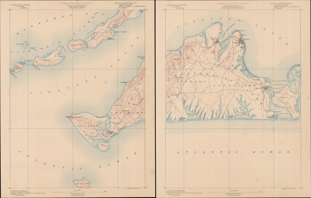
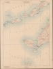
A two-sheet 1887 U.S. Geological Survey map of Martha's Vineyard and other nearby islands, surveyed and published in 1887 by the U.S. Geological Survey. These sheets constitute the first 'preliminary edition' of this map, which continued to be the standard map of Martha's Vineyard by the Geological Survey until 1919.
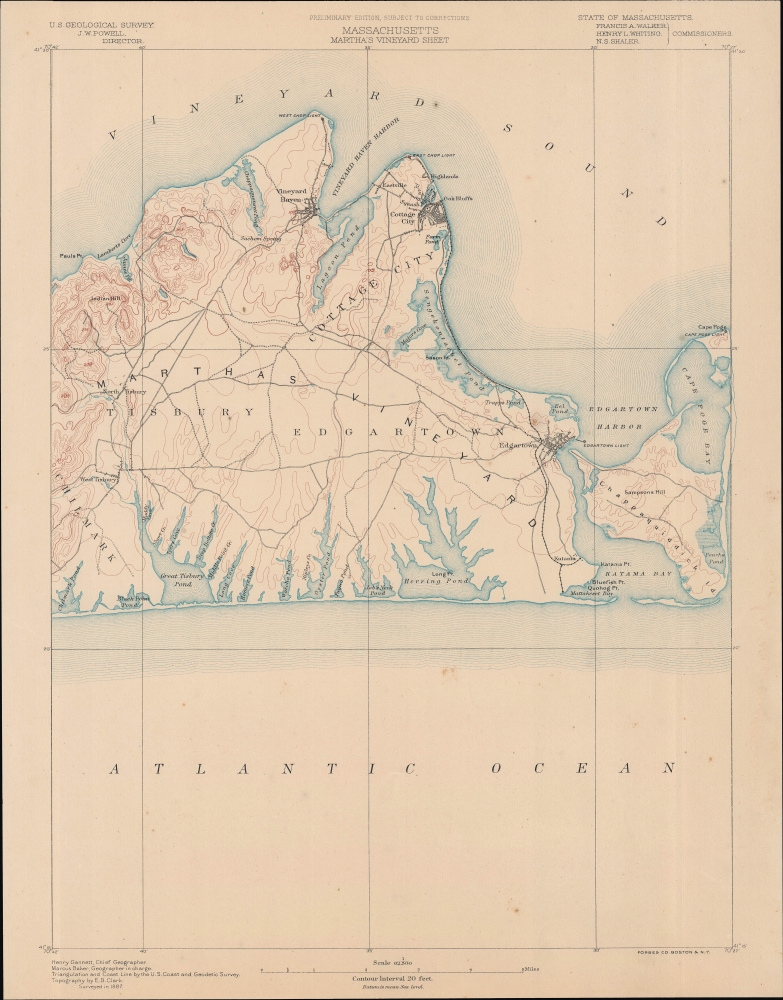
The right sheet contains the bulk of Martha’s Vineyard from Chilmark to Chappaquiddick Island and Cape Pogue Bay, including both Edgartown and Vineyard Haven. Notably, the town now known as Oak Bluffs is marked here as 'Cottage City,' its name after separating from Edgartown in 1880 before being reincorporated into the latter under its present name in 1907.
Like nearby Nantucket, Martha's Vineyard's fortunes rose and fell with the whaling industry in the 19th century. However, Martha's Vineyard rebounded more quickly when whaling died off in the late 19th century and established itself as a tourist destination, thanks in large part to the Old Colony Railroad, seen running down the right side of the island here. Elite New England families liked the island so much that they built summer homes there, securing Martha's Vineyard's reputation as a home for the rich, famous, and powerful.
A Closer Look
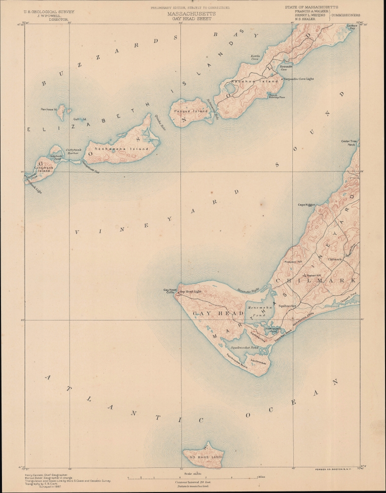
The left sheet details Gay Head and Chilmark as well as parts of Buzzard Bay and the Elizabeth Islands of Cuttyhunk, Nashawena, Pasque, and Naushon. A smaller island to the south of Gay Head is identified as 'No Mans Land'. Topographical features such as Squibnocket Beach, Prospect Hill, the Nashaquitsa Cliffs, Stone Wall Beach, Peaked Hill, and the Tiasquam River are noted. The various roads traversing the region, the Gay Head Lighthouse, the Tarpaulin Cove Lighthouse, and the Cuttyhunk Lighthouse are all labeled.The right sheet contains the bulk of Martha’s Vineyard from Chilmark to Chappaquiddick Island and Cape Pogue Bay, including both Edgartown and Vineyard Haven. Notably, the town now known as Oak Bluffs is marked here as 'Cottage City,' its name after separating from Edgartown in 1880 before being reincorporated into the latter under its present name in 1907.
Like nearby Nantucket, Martha's Vineyard's fortunes rose and fell with the whaling industry in the 19th century. However, Martha's Vineyard rebounded more quickly when whaling died off in the late 19th century and established itself as a tourist destination, thanks in large part to the Old Colony Railroad, seen running down the right side of the island here. Elite New England families liked the island so much that they built summer homes there, securing Martha's Vineyard's reputation as a home for the rich, famous, and powerful.
Publication History and Census
Surveyed in 1887 and prepared by Henry Gannett, Marcus Baker, and E. B. Clark, this 'preliminary edition' map of Martha's Vineyard is among the most sought after topographical maps produced by the U.S. Geological Survey. The David Rumsey Historical Map Collection includes the map, also marked 'preliminary edition,' as they appeared as sheets 42 and 47 in the 1890 Atlas of Massachusetts from Topographical Surveys (also previously sold by us). The present sheets, however, are unnumbered and presumably predate the atlas.Cartographer
The Office of the Coast Survey (later the U.S. Geodetic Survey) (1807 - present), founded in 1807 by President Thomas Jefferson and Secretary of Commerce Albert Gallatin, is the oldest scientific organization in the U.S. Federal Government. Jefferson created the "Survey of the Coast," as it was then called, in response to a need for accurate navigational charts of the new nation's coasts and harbors. The first superintendent of the Coast Survey was Swiss immigrant and West Point mathematics professor Ferdinand Hassler. Under the direction of Hassler, from 1816 to 1843, the ideological and scientific foundations for the Coast Survey were established. Hassler, and the Coast Survey under him developed a reputation for uncompromising dedication to the principles of accuracy and excellence. Hassler lead the Coast Survey until his death in 1843, at which time Alexander Dallas Bache, a great-grandson of Benjamin Franklin, took the helm. Under the leadership A. D. Bache, the Coast Survey did most of its most important work. During his Superintendence, from 1843 to 1865, Bache was steadfast advocate of American science and navigation and in fact founded the American Academy of Sciences. Bache was succeeded by Benjamin Pierce who ran the Survey from 1867 to 1874. Pierce was in turn succeeded by Carlile Pollock Patterson who was Superintendent from 1874 to 1881. In 1878, under Patterson's superintendence, the U.S. Coast Survey was reorganized as the U.S. Coast and Geodetic Survey (C & GS or USGS) to accommodate topographic as well as nautical surveys. Today the Coast Survey is part of the National Oceanic and Atmospheric Administration or NOAA. More by this mapmaker...
Condition
Very good. Light soiling and toning.
References
Rumsey 2883.048, 2883.043 (1890 editions).