This item has been sold, but you can get on the Waitlist to be notified if another example becomes available, or purchase a digital scan.
1860 U.S. Coast Survey Map of Block Island, Buzzard Bay, Nantucket and Marthas Vineyard
MarthasVineyardNantucket-uscs-1860$1,750.00

Title
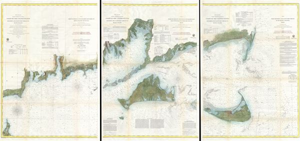
Preliminary Coast Charts Nos. 12, 13 & 14. Coast of the United States Monomoy and Nantucket Shoals to Block Island. / No. 14 From Entrace to Buzzard's Bay Mass. to Block Island Sound R.I. / No. 13 From Muskeget Channel to Buzzard's Bay and Engrance to Vineyard Sound Mass. / No. 12 From Monomoy and Nantucket Shoals to Muskeget Channel Mass.
1860 (dated) 38 x 82 in (96.52 x 208.28 cm)
1860 (dated) 38 x 82 in (96.52 x 208.28 cm)
Description
A scarce and extraordinary 1860 set of three large format nautical charts covering from Block Island and Buzzard Bay eastward to include all of Martha's Vineyard (Marthas Vineyard) and Nantucket. This map set consists of three separate nautical charts which can be joined into a single sheet or framed as a triptych.
From the left, the westernmost map (No. 14) in the series depicts the coast from Rhode Island from Block Island to the entrance to Buzzard Bay, Massachusetts. The city of Newport is identified. The whole is detailed to the level of individual buildings and roads. From a maritime perspective this chart offers innumerable depth soundings throughout. Text in the upper quadrants includes sailing instructions, notations on light houses, magnetic variations, tide and currents. The title of chart it set in the upper right quadrant. The title for the three map series is set in the upper left quadrant.
The central map (No. 13) depicts Buzzard Bay and this Island of Martha's Vineyard in gull. It identifies the cities of New Bedford and Edgartown. The whole is detailed to the level of individual buildings and roads. From a maritime perspective this chart offers innumerable depth soundings throughout and illustrates the many hidden shoals in the area. Text areas in the lower half of the map offer sailing instructions and notes on ranges and bearings. Text in the upper quadrants includes notations on light houses, magnetic variations, tide and currents. The title of this chart is presented in the upper right quadrant. The title for the three map series is presented in the upper left quadrant.
The eastern map (no. 12) covers the island of Nantucket and part of Cape Cod, Massachusetts. The whole is detailed to the level of individual buildings and roads. From a maritime perspective, this chart offers innumerable depth sounding throughout and illustrates many of the dangerous shoals in the area. The upper right quadrant has detailed sailing instructions and notes on magnetic variations, light houses, and dangers. Title of chart is also presented in the upper right quadrant. The title of the three map series is presented in the upper left quadrant.
The triangulation and topography for this map set was accomplished by a team under the supervision of A.D. Bache, director of the U.S. Coast Survey. Engraved by A. Hoen and Co. of Baltimore for the 1860 edition of the Surveyor General's Report
Cartographer
The Office of the Coast Survey (1807 - present) founded in 1807 by President Thomas Jefferson and Secretary of Commerce Albert Gallatin, is the oldest scientific organization in the U.S. Federal Government. Jefferson created the "Survey of the Coast," as it was then called, in response to a need for accurate navigational charts of the new nation's coasts and harbors. The spirit of the Coast Survey was defined by its first two superintendents. The first superintendent of the Coast Survey was Swiss immigrant and West Point mathematics professor Ferdinand Hassler. Under the direction of Hassler, from 1816 to 1843, the ideological and scientific foundations for the Coast Survey were established. These included using the most advanced techniques and most sophisticated equipment as well as an unstinting attention to detail. Hassler devised a labor intensive triangulation system whereby the entire coast was divided into a series of enormous triangles. These were in turn subdivided into smaller triangulation units that were then individually surveyed. Employing this exacting technique on such a massive scale had never before been attempted. Consequently, Hassler and the Coast Survey under him developed a reputation for uncompromising dedication to the principles of accuracy and excellence. Unfortunately, despite being a masterful surveyor, Hassler was abrasive and politically unpopular, twice losing congressional funding for the Coast Survey. Nonetheless, Hassler led the Coast Survey until his death in 1843, at which time Alexander Dallas Bache, a great-grandson of Benjamin Franklin, took the helm. Bache was fully dedicated to the principles established by Hassler, but proved more politically astute and successfully lobbied Congress to liberally fund the endeavor. Under the leadership of A. D. Bache, the Coast Survey completed its most important work. Moreover, during his long tenure with the Coast Survey, from 1843 to 1865, Bache was a steadfast advocate of American science and navigation and in fact founded the American Academy of Sciences. Bache was succeeded by Benjamin Pierce who ran the Survey from 1867 to 1874. Pierce was in turn succeeded by Carlile Pollock Patterson who was Superintendent from 1874 to 1881. In 1878, under Patterson's superintendence, the U.S. Coast Survey was reorganized as the U.S. Coast and Geodetic Survey (C & GS) to accommodate topographic as well as nautical surveys. Today the Coast Survey is part of the National Oceanic and Atmospheric Administration or NOAA as the National Geodetic Survey. More by this mapmaker...
Source
Report of the Superintendant of the U.S. Coast Survey, (1860 edition).
Condition
Very good condition. Professionally backed with japanese paper. Minor discoloration on original folds. Blank on verso. Three separate charts.
References
Office of the U.S. Coast Survey Historical Map and Chart Project, #12_13_14-00-1860.