1765 Tirion Map of Martinique
Martinique-tirion-1765$250.00
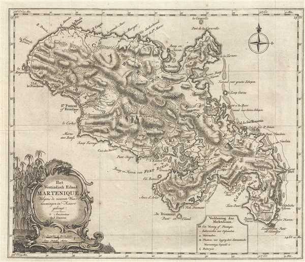

Title
Het Westindisch Eiland Martenique Volgens de nieuwste Waar neemingen in Kaart gebragt.
1765 (undated) 12.25 x 14.75 in (31.115 x 37.465 cm) 1 : 166000
1765 (undated) 12.25 x 14.75 in (31.115 x 37.465 cm) 1 : 166000
Description
This is a c. 1765 Isaak Tirion map of the Caribbean island of Martinique. The map depicts the whole of the island from Grande Rivière to Pointe Varin and from St. Pierre of Roxelane to La Caravelle. Highly detailed, numerous locations are labeled both along the coast and in the island's interior. Hilly topography is illustrated, as well as myriad trees. Depth soundings are recorded near Fort Royal, but are absent everywhere else on the map. Safe harbors are noted by small anchors in several locations, including in the Cul de Sac Marin and in the Cul de Sac Robert. Shoals and other hazards are illustrated off the coast, along with numerous smaller islands. A decorative title cartouche is situated in the lower left corner.
This map was produced by Isaak Tirion and published in Amsterdam c. 1765.
This map was produced by Isaak Tirion and published in Amsterdam c. 1765.
Cartographer
Isaak Tirion (1705 - 1765) was a Dutch publisher in Amsterdam. Born in Utrecht, Tirion quickly rose to prominence by publishing pamphlets, historical works, and most importantly, maps and atlases. He produced several atlases and Dutch town plans. His maps are mainly based on those of Guillaume de l'Isle. Tirion eventually relocated his printing house to the prestigious Kalverstraat. In his long career, he produced eight atlases in multiple editions, some of which were published posthumously until about 1784. More by this mapmaker...
Condition
Very good. Minor wear along original fold lines. Blank on verso.
References
OCLC 71400705.