
This item below is out of stock, but another example (left) is available. To view the available item, click "Details."
Details
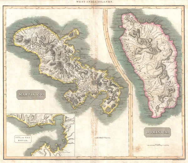
1814 Thomson Map of Martinique and Dominica (West Indies)
1814 (undated) $250.00
1814 Thomson Map of Martinique and Dominica ( West Indies )
MartiniqueDominica-thomson-1814$150.00

Title
West India Islands. / Martinico. / Dominica. / Cul de Sac Royal.
1814 (undated) 20.5 x 23.5 in (52.07 x 59.69 cm)
1814 (undated) 20.5 x 23.5 in (52.07 x 59.69 cm)
Description
A fine example of John Thomson's stunning c. 1814 map of the West India islands of Dominica and Martinique. Divided into two sections, this map offers spectacular detail of these two picturesque islands. Both sections offer detail to the level of individual buildings noting churches, convents, villages, hospitals and forts. Also notes some sailing hazards and portages. Both also show mountains, rivers, caves, forests, and river systems. In the lower left hand quadrant there is an inset of the Cul-de-Sac Royal (modern day Fort-de-France). Engraved by Kirkwood and Son of Edinburgh for the 1817 edition of John Thomson's General Atlas.
Cartographer
John Thomson (1777 - c. 1841) was a Scottish cartographer, publisher, and bookbinder active in Edinburgh during the early part of the 19th century. Thomson apprenticed under Edinburgh bookbinder Robert Alison. After his apprenticeship, he briefly went into business with Abraham Thomson. Later, the two parted ways, John Thomson segueing into maps and Abraham Thomson taking over the bookbinding portion of the business. Thomson is generally one of the leading publishers in the Edinburgh school of cartography, which flourished from roughly 1800 to 1830. Thomson and his contemporaries (Pinkerton and Cary) redefined European cartography by abandoning typical 18th-century decorative elements such as elaborate title cartouches and fantastic beasts in favor of detail and accuracy. Thomson's principle works include Thomson's New General Atlas, published from 1814 to 1821, the New Classical and Historical Atlas of 1829, and his 1830 Atlas of Scotland. The Atlas of Scotland, a work of groundbreaking detail and dedication, would eventually bankrupt the Thomson firm in 1830, at which time their plates were sequestered by the court. The firm partially recovered in the subsequent year, allowing Thomson to reclaim his printing plates in 1831, but filed again for bankruptcy in 1835, at which time most of his printing plates were sold to A. K. Johnston and Company. There is some suggestion that he continued to work as a bookbinder until 1841. Today, Thomson maps are becoming increasingly rare as they are highly admired for their impressive size, vivid hand coloration, and superb detail. More by this mapmaker...
Source
Thomson, John. A new general atlas, consisting of a series of geographical designs, on various projections, exhibiting the form and component parts of the globe; and a collection of maps and charts, delineating the natural and political divisions of the empires, kingdoms, and states in the World. Constructed from the best systematic works, and the most authentic voyages and travels. With a memoir of the progress of geography, a summary of physical geography, and a consulting index to facilitate the finding out of places., (1817 edition)
Condition
Very good. Minor offsetting and some spotting along original centerfold. Blank on verso.
References
Rumsey 1007.072. Phillips (Atlases) 731. Newberry Library: Ayer +135 T4 1817.