This item has been sold, but you can get on the Waitlist to be notified if another example becomes available, or purchase a digital scan.
1886 Manuscript Map of Pecol Rum / Sugar Plantations, Martinique
MartiniquePecoul-lespes-1886$3,750.00


Title
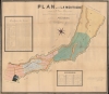
Plan de l'Htion La Montagne situèe a St. Pierre-Martinique contenant 521 hectares, 08 ares, 83 centiares, appartenant aux hèritiers Pécoul.
1886 (dated) 47 x 53.75 in (119.38 x 136.525 cm) 1 : 4000
1886 (dated) 47 x 53.75 in (119.38 x 136.525 cm) 1 : 4000
Description
This large-scale 1886 manuscript wall map illustrates the original sugar plantation and rum refiners of the Pécoul family, the 'Habitation la Montagne', Martinique. The map illustrates the hey-day French colonial plantation culture and rum production in Martinique, before the 1902 eruption of Mount Pelée.
A Closer Look
Coverage embraces the lands to the west of Saint-Pierre roughly to Morne-Route, between the Rivière des Pères to the north and the Rivière Madame to the south. The plantation estate, today rebuilt as Chateau Depaz, appears in the lower left. Fields sweep out to the northeast, all numbered and associated with two corresponding tables, one being a soil analysis, the other a breakdown of individual plots of lands. Within the map distances are also noted.'Habitation la Montagne'
This 'habitation', as the large Martinique plantations were known, rests in a fertile valley at the foot of Mount Pelée. It was founded in 1651 by Jacques Duparquet as the 'Habitation la Montagne'. Joseph Pécoul acquired the estate in 1810, growing indigo, tobacco, and sugar. During the Sugar Crises of the 1800s, the estate was converted to rum production, at which point it emerged as one of the primary rum estates in Martinique. It continued as such until 1902, when the eruption of Mount Pelée destroyed the habitation and nearby city of Saint-Pierre - a cultural capital then known as the 'Paris of the Caribbean'. In 1909, Victor Depaz acquired the ruined plantation and rebuilt the distillery, which continues to produce rum as Habitation Depaz. Rum Pécoul relocated to a different part of the island and itself still produces.Publication History and Census
This map is a unique manuscript prepared by Laguarigue de Chevillier, a notary in Martinique, copied in manuscript from an older survey in the Saint-Pierre records by M. H. Lespès. Likely prepared for the purpose of plantation management.Condition
Good. Manuscript. Original linen backing. Some restoration and discoloration. Edge wear. Surface abrasion.