This item has been sold, but you can get on the Waitlist to be notified if another example becomes available, or purchase a digital scan.
1819 Fielding Lucas Map of Maryland, Baltimore
MarylandBaltimore-lucas-1819$850.00


Title
Maryland.
1819 (undated) 11.75 x 19.75 in (29.845 x 50.165 cm) 1 : 750000
1819 (undated) 11.75 x 19.75 in (29.845 x 50.165 cm) 1 : 750000
Description
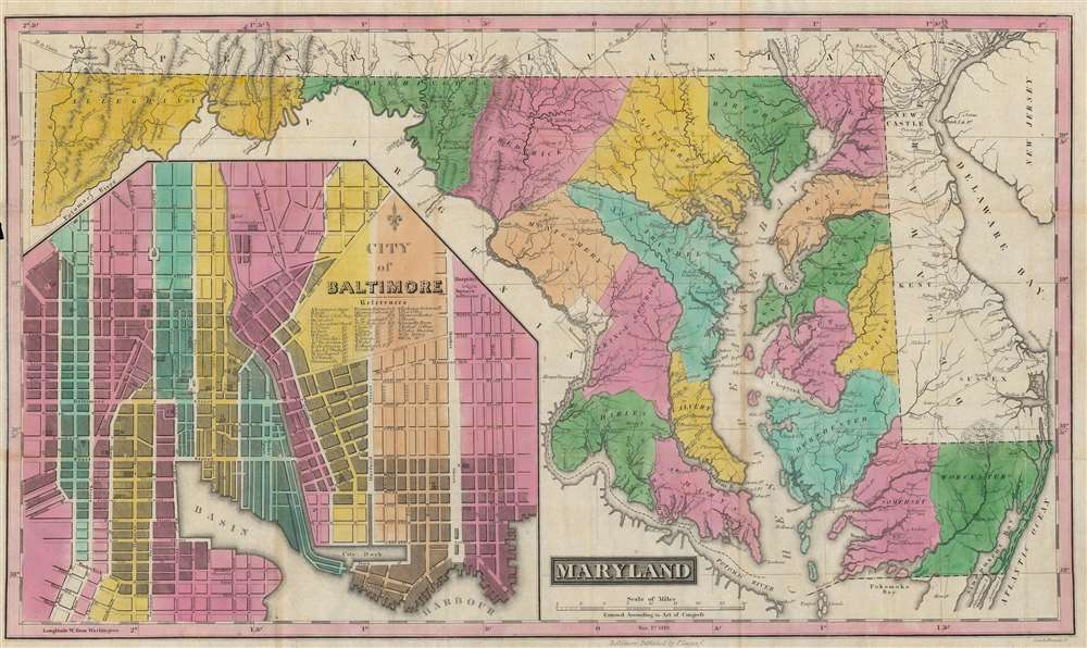
This is a rare and brilliantly colored example of Fielding Lucas' 1819 map of Maryland, with a large inset of Baltimore. It was made in the aftermath of the War of 1812, when Baltimore had been the site of a critical American victory in 1814.
A Closer Look
Employing a curious layout, the map is nearly divided in half between Maryland at right and Baltimore at left. The Maryland map indicates the state's counties, along with cities, roads, rivers, and areas of elevation. Washington, D.C., marked at center, serves as Prime Meridian; the city was captured and partially burned a few weeks before the Battle of Baltimore in 1814. The Potomac River and the Chesapeake Bay are prominent at right, and the Delaware Bay at far right. The inset plan of Baltimore includes a legend with letters corresponding to important sites throughout the city (mostly churches).Historical Context
This map was produced in the wake of the War of 1812, which saw significant fighting in and around Baltimore during the Chesapeake Campaign. The campaign began very badly for the Americans, with the British capturing the nation's capital in late August 1814 and setting fire to important public buildings. They next moved on Baltimore in early September but were repulsed on land (at North Point) and at sea (at Fort McHenry), with their commander General Robert Ross killed by American snipers. Unable to maneuver into a better position, the British retreated from Baltimore, giving the Americans a badly needed morale boost. The defense of Fort McHenry inspired Francis Scott Key to write the 'Star Spangled Banner.'Publication History and Census
This map was drafted by Fielding Lucas and engraved by Cone and Freeman in 1819. It resembles, with some important differences (namely the inset map of Baltimore), Lucas' 1816 map of Maryland in his A New and Elegant General Atlas Containing Maps of each of the United States, which was engraved by Henry Tanner. The present map was later reissued as part of Lucas' A General Atlas Containing Distinct Maps of all the Known Countries in the World, Constructed from the Latest Authority in 1822 and 1823. The 1819 edition of the map is only known to be held by Duke University and the Enoch Pratt Free Library in Baltimore, and has no known history on the market.Cartographer
Fielding Lucas Jr. (September 3, 1781 - March 12, 1854) was an American cartographer, chartmaker, and publisher active in Baltimore during the first half of the 19th century. Born in Fredericksburg, Virginia, little is known of Lucas's family and early life, but his lineage seems to have been established in Fredericksburg from at least the mid-1700s. Lucas founded Lucas Brothers, one of America's first stationers located at 116 East Baltimore Street, in 1804 and later, in 1806, he became the Baltimore manager of the Philadelphia based publishing firm Conrad, Lucas, and Company. Lucas is also known to have worked with the Matthew Carey firm in Philadelphia. Lucas entered the map trade around 1814, when he published an atlas of the United States - similar to, but in direct competition with, Matthew Carey, a matter which soured an otherwise profitable friendship. In 1825, Lucas also produced a world atlas. Over the course of his career, Lucas published several smaller atlases and numerous independent issue maps, including an important nautical chart of the Chesapeake and Delaware Bays. Many of his maps were engraved by H. S. Tanner, but he also worked with Robert Mills (Atlas of South Carolina) and others. Lucas attained considerable social prominence as a patron of the arts and philanthropist. He was a member of the committee that helped build Baltimore's Washington Monument and was one of the founding members of the Boston Harmonic Society and the Maryland Institute for the Promotion of Mechanical Arts. During the War of 1812, Lucas enlisted in Captain John Kanes' Company, 27th Maryland Regiment, although little is known of his actual service. From 1827 he served as a director of the Baltimore and Ohio Railroad and, later, as director of the Baltimore and Rappahannock Steam Packet Company. He died in Baltimore on March 12, 1854. (Foster, J. W., Fielding Lucas, Jr., Early 19th Century American Publisher of Fine Books and Maps, 'American Antiquarian Society', October 1955, Volume 64, Part 2, 162-212) More by this mapmaker...
Condition
Good. Discoloration along fold lines in places. Chip in left-hand margin.
References
OCLC 70920982.