This item has been sold, but you can get on the Waitlist to be notified if another example becomes available, or purchase a digital scan.
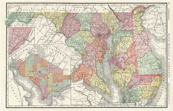
1888 Rand McNally Map of Delaware, Maryland and Washington D.C.
MarylandDelawareDC-randmcnally-1893$45.00

Title
Delaware. Maryland and D.C.
1888 (dated) 13 x 20 in (33.02 x 50.8 cm) 1 : 720000
1888 (dated) 13 x 20 in (33.02 x 50.8 cm) 1 : 720000
Description
This is a fine example of Rand McNally and Company's 1888 map of Maryland and Delaware. It covers both states along with parts of adjacent states. Garret, the western part of Maryland, is detailed in an inset near the left margin. The map notes several towns, cities, rivers, railways and an assortment of additional topographical details throughout. This map is color coded according to counties with relief shown by hachure.
A large inset map of the District of Columbia is included in the lower left quadrant of the map. This highly detailed map reveals the city in considerable detail with color coding according to ward. Several important buildings and monuments including the Washington monument, the Capitol, the White House (not yet called the White House, but the President's House), City Hall, Navy Yard, and others are noted. The city's famous grid and ray structure appears according to Ellicott's updated version of L'Enfant's brilliant plan. Georgetown appears in the upper left corner with Georgetown College noted just outside the city border.
This map was issued as plate no. 98 in the 1893 edition of Rand McNally and Company's Indexed Atlas of the World- possibly the finest atlas Rand McNally ever issued.
Cartographer
Rand, McNally and Co. (fl. 1856 - present) is an American publisher of maps, atlases and globes. The company was founded in 1856 when William H. Rand, a native of Quincy, Massachusetts, opened a print shop in Chicago. Rand hired the recent Irish immigrant Andrew McNally to assist in the shop giving him a wage of 9 USD per week. The duo landed several important contracts, including the Tribune's (later renamed the Chicago Tribune) printing operation. In 1872, Rand McNally produced its first map, a railroad guide, using a new cost effective printing technique known as wax process engraving. As Chicago developed as a railway hub, the Rand firm, now incorporated as Rand McNally, began producing a wide array of railroad maps and guides. Over time, the firm expanded into atlases, globes, educational material, and general literature. By embracing the wax engraving process, Rand McNally was able to dominate the map and atlas market, pushing more traditional American lithographic publishers like Colton, Johnson, and Mitchell out of business. Eventually Rand McNally opened an annex office in New York City headed by Caleb S. Hammond, whose name is today synonymous with maps and atlases, and who later started his own map company, C. S. Hammond & Co. Both firms remain in business. More by this mapmaker...
Source
Rand McNally & Co., Rand, McNally & Co's Indexed Atlas of the World, (Chicago) 1893.
Condition
Very good. Text on verso.
References
Rumsey 2094.023 (1889 edition). Philips (atlases) 952.