This item has been sold, but you can get on the Waitlist to be notified if another example becomes available, or purchase a digital scan.
1895 Stanford Map of Eastern South Africa
Mashonaland-stanford-1895$1,250.00

Title
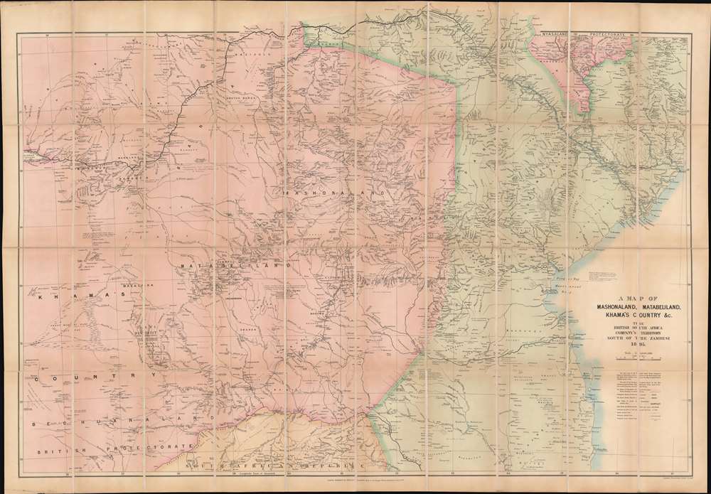
A Map of Mashonaland, Matabeliland, Khama's Country, etc. The British South Africa Company's Territory South of the Zambesi.
1895 (dated) 37 x 53.5 in (93.98 x 135.89 cm) 1 : 1000000
1895 (dated) 37 x 53.5 in (93.98 x 135.89 cm) 1 : 1000000
Description
An imperial and colonial map at its finest, this is an 1895 Edward Stanford map of southeastern Africa lauds the land 'acquisitions' of the British South Africa Company and speculates on the mineral wealth present in the region. Published the year Rhodesia was founded, the map depicts the region from Bechuanaland (modern-day Botswana) to Portuguese Mozambique and from the Zambezi River to the South African Republic. Black block letters label goldfields, and small black bars mark gold reefs and mines. Pink highlights the lands, or 'sphere of operations' of the British South Africa Company, green denotes Portuguese Mozambique, which the British South Africa Company believed could be conquered, and orange the South African Republic. Like many maps of Africa in the late 19th century this map served the dual purpose of assisting in exploitation and infrastructure devilment, and of supporting evidence for 'Effective Occupation.'
The British South Africa Company
The British South Africa Company (BSAC), a colonial mining company with a Royal Charter. Chartered in 1889, the BSAC was formed by combining Cecil Rhodes' Central Search Association with the London-based Exploring Company Ltd. Founded to mine the mineral wealth of Mashonaland, the former competitors joined forces to receive a Royal Charter. The BSAC initially hoped to create a zone of British economic influence from 'Cairo to the Cape.' But Mashonaland's mineral riches proved less grand than expected, and the BSAC could barely afford the upkeep costs on the railways and other infrastructure projects. Rhodesia was founded in 1895 and administered by the BSAC until 1924. The BSAC largely ignored Southern Rhodesia's elected legislative council and no representative government, even for the settler community, existed in Northern Rhodesia until after the BSAC administration ended in 1924.Effective Occupation
The 1884-85 Berlin Conference adopted the Doctrine of Effective Occupation as a baseline for establishing and maintaining colonial claims. According to this doctrine, colonial powers needed to prove 'effective occupation.' This means they needed to establish the existence of treaties with local powers, show that their flags were being flown, or have active forts in the region. The doctrine led to increased European military and economic activity in Africa as individual powers sought to bolster their 'effective occupation' claims. While this, in part, led to the advancement of infrastructure in Africa, including the construction of modern facilities such as hospitals and railroads, it also led to more intensive direct ownership of colonial lands by Europeans and the exploitation of indigenous peoples.Publication History and Census
This map was created and published by Edward Stanford in 1895. Two examples are cataloged in OCLC and are part of the institutional collections at Yale and the Bibliothèque nationale de France.Cartographer
Edward Stanford (May 27, 1827 - November 3, 1904) was one of the most prolific map publishing firms of the late 19th century. The company began as a partnership in 1848 between the 21 year old Edward Stanford and the established map dealer Trelawney Saunders. By 1853 the partnership had dissolved and Edward Stanford took full control of the business. A subsequent series of expansions and exciting new map issues finally led to the production of Stanford's masterwork, "Stanford's Library Map of London". This map is still available and remains somewhat accurate. At the time of publishing it was hailed by the Royal Geographical Society as "the most perfect map of London that has ever been issued". In 1882 Edward Stanford Sr. passed the firm on to his son, Edward Stanford Jr. who continued in his father's proud tradition. Today the Stanford firm still publishes maps and remains one of the most important and prolific cartographic publishers in the world. More by this mapmaker...
Condition
Very good. Dissected and mounted on original linen, which is stable. Folds into original binder.
References
OCLC 57711832.