1930 Brickhouse Studios Pictorial Map of Massachusetts
Massachusetts-brickhouse-1930$500.00

Title
Massachusetts.
1930 (undated) 19.5 x 24.25 in (49.53 x 61.595 cm) 1 : 440000
1930 (undated) 19.5 x 24.25 in (49.53 x 61.595 cm) 1 : 440000
Description
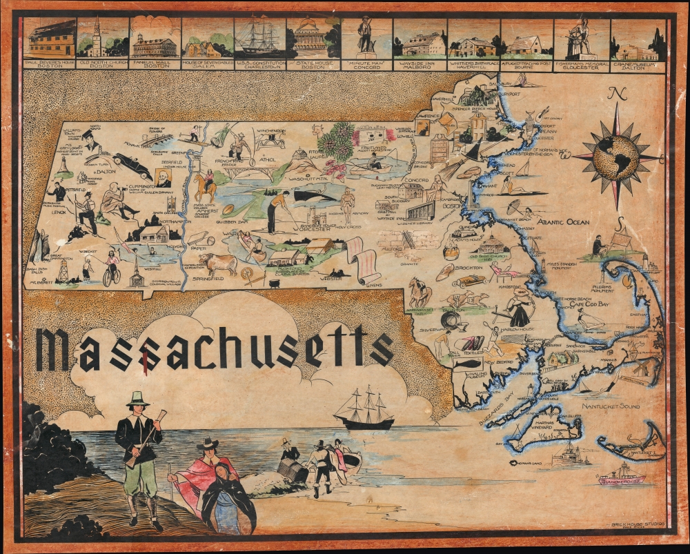
A charming celebration of Massachusetts' history, this highly scarce pictorial map was produced by Brickhouse Studios c. 1930. It is replete with references to the colonial and revolutionary era, educational institutions, industries, and Massachusetts' nautical heritage (fishing, whaling, lighthouses).
An elaborate compass rose adds flourish to the map. The boat at bottom-right named Handkerchief is a curious inclusion, but the ship was likely named after the Handkerchief Shoal between Nantucket and Cape Cod. Another interesting feature of the map is the prominence of the Southwick 'jog,' a jutting piece of southwestern Massachusetts resulting from a late 18th century territorial dispute with Connecticut.
A Closer Look
Coverage includes the entire commonwealth, from the Berkshires in the west to Cape Cod, Nantucket, and Martha's Vineyard in the east. Waterways, cities, towns, and mountains are indicated, but the highlight of the work is the illustrations, which reflect the history, economy, culture, and leisure activities of different localities. Additional illustrations are included along the top border, portraying sites in and around Boston especially, while a larger one at bottom-left depicts a group of Pilgrims landing, presumably at Plymouth Rock.An elaborate compass rose adds flourish to the map. The boat at bottom-right named Handkerchief is a curious inclusion, but the ship was likely named after the Handkerchief Shoal between Nantucket and Cape Cod. Another interesting feature of the map is the prominence of the Southwick 'jog,' a jutting piece of southwestern Massachusetts resulting from a late 18th century territorial dispute with Connecticut.
Publication History and Census
This map was produced by York, Maine-based Brickhouse Studios around the year 1930. This appears to be the only work ever produced by the studio. We are only aware of one other example of this map, which is in private hands.Condition
Average. Varnished, some buckling, and reinforced areas on verso. Some scuffing and loss on surface.