1856 Schoolboy or Schoolgirl Manuscript Map of Massachusetts
MassachusettsManuscript-unknown-1856$1,200.00

Title
Massachusetts 1856.
1856 (dated) 8.75 x 11.75 in (22.225 x 29.845 cm) 1 : 1090000
1856 (dated) 8.75 x 11.75 in (22.225 x 29.845 cm) 1 : 1090000
Description
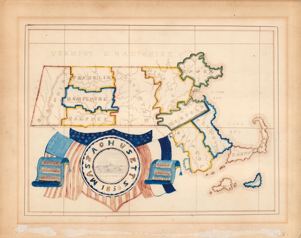
A visually pleasing c. 1856 manuscript schoolgirl map of Massachusetts divided into its counties. This work represents a fine example of the 19th century schoolgirl map genre.
The goals of these exercises were more far-reaching than teaching geography. Girls learned penmanship, each map often using three or more lettering styles. Mapmaking sharpened the retention and recall of factual information. Students were encouraged to take pains in their draftsmanship, and often achieved beautiful flourishes of artistic expression. But most peculiar to the American iterations of educational mapping was the goal of instilling a sense of civic pride and responsibility. Indeed, the key desired result of the education of girls in the post-Revolutionary-War United States was to prepare for the education of the next generation of American citizens, a patriotic duty which would primarily fall on the shoulders of these young women.
For a good overview, see Betty Mason's '19th Century Schoolgirls Were Incredibly Good at Drawing Maps.' Published July 27, 2016 by National Geographic.
A Closer Look
The counties of Massachusetts are outlined in bold color, including insular Dukes and Nantucket Counties, and a relatively understated Suffolk County at right. Portions of neighboring states (Vermont, New Hampshire, New York, and, not labelled, Connecticut and Rhode Island) also are included. Rivers are illustrated throughout, as are the Berkshires at left. A patriotic title cartouche appears at bottom-left, with banners listing the names of the commonwealth's counties and a view of Boston at center.Schoolboy / Schoolgirl Maps
While the use of mapmaking in teaching is first seen in Europe, mainly England, the Schoolgirl Map became a peculiarly American pedagogical tool in the first part of the 19th Century, a period wherein the standards and purposes in women's education were changing. While boys were frequently taught the practical execution of surveys and charts, the production of attractive and informative maps appear to have been primarily the domain of young women. Such maps can be found of the World, the United States, or more specific maps of states. These were usually based on generally available reference maps, such as those found in the atlases of Carey and Lea, Finley, and Mitchell.The goals of these exercises were more far-reaching than teaching geography. Girls learned penmanship, each map often using three or more lettering styles. Mapmaking sharpened the retention and recall of factual information. Students were encouraged to take pains in their draftsmanship, and often achieved beautiful flourishes of artistic expression. But most peculiar to the American iterations of educational mapping was the goal of instilling a sense of civic pride and responsibility. Indeed, the key desired result of the education of girls in the post-Revolutionary-War United States was to prepare for the education of the next generation of American citizens, a patriotic duty which would primarily fall on the shoulders of these young women.
For a good overview, see Betty Mason's '19th Century Schoolgirls Were Incredibly Good at Drawing Maps.' Published July 27, 2016 by National Geographic.
Publication History and Census
This map was most likely produced by a schoolchild, making it part of the schoolboy/schoolgirl genre of 19th century American manuscript maps. These unique productions have become increasingly valuable and collectible in recent decades.Condition
Fair. Uneven toning in the margin. Adhesive or matting residue in the bottom margin.