
1917 Justus Perthes Topographic Wall Map of the Matterhorn, Italian-Swiss Alps

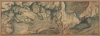

Haack Bild und Karte., No. 3. Monte Rosa - Matterhorn...
The Mighty Matterhorn in splendid topographic detail.
- Digital Map Information
- Suitable for large format printing
- File Size: 154.3 MB
- File Type: ZIP / TIFF
- ICC color profile embedded
- Delivered instantly via download link
The Mighty Matterhorn in splendid topographic detail.
This is a massive (28 x 77 in.) c. 1917 Justus Perthes wall map of a portion of the Alps along the Italian-Swiss border, including the famous Matterhorn. Published at the height of the early 20th-century alpine mountaineering boom, it provides a meticulous topographical overview of the Monte Rosa-Matterhorn region, one of the most challenging and storied areas for mountaineering in the world.A Closer Look
Oriented with south at top, this stunning topographic map covers a portion of the Alps along the Italian-Swiss border between Monte Rosa in the east and the Matterhorn in the west. The scale (1:12,500) and color gradations allow for the display of tremendous detail, the culmination of decades of improvements in topographical mapping for alpine hikers and mountaineers. Aside from peaks and ridges with their elevations, contour lines are traced throughout. Waterways, glaciers, buildings, and other features are recorded.The Mighty Matterhorn
Standing as an iconic, four-sided pyramid on the border between Switzerland and Italy, the Matterhorn (4,478 meters) was long considered the 'last great problem' of the Alps. For much of the 19th century, while other major peaks were being conquered, the Matterhorn's sheer rock faces and crumbling ridges inspired such dread that local legends claimed the summit was a fortress for spirits and physically inaccessible to man. This aura of invincibility sparked a legendary rivalry during the Golden Age of Alpinism, primarily between the British artist Edward Whymper (1840 - 1911) and the Italian guide Jean-Antoine Carrel (1829 - 1891). While Carrel was driven by patriotic fervor to claim the peak for Italy via the 'Lion Ridge', Whymper spent years obsessed with the mountain, surviving 7 failed attempts and narrow escapes.The struggle for the summit reached its climax on July 14, 1865, when Whymper's party of 7 successfully reached the top, beating Carrel's Italian team by a mere 200 meters. However, the triumph was immediately overshadowed by a disaster that would define the mountain's history. During the descent, a young climber named Douglas Hadow slipped and knocked over the lead guide, Michel Croz, dragging two other men with them. The rope snapped between the falling climbers and the survivors, and four men plummeted to their deaths on the glacier below. This tragedy sent shockwaves across Europe - sparking an inquiry and even causing Queen Victoria to consider banning mountaineering - but it ultimately transformed the quiet village of Zermatt into a world-famous tourist destination. The event is now recognized as the definitive end of the Golden Age of Alpinism, marking the transition from the era of exploration to the technical, high-stakes sport of modern climbing.
Publication History and Census
This map was part of a series of five maps (Geographische Längsbilder und Rundblicke mit Kartenergänzungen) prepared by Michael Zeno Diemer, Ernst Enzensperger,, and Hermann Haack, and published by Justus Perthes. The map's tremendous size, and the A. J. Nystrom and Company sticker at bottom, suggest intended use in a classroom rather than in the field. Despite the lack of a date on the map, it is generally dated to between 1915 and 1917. Due to uncertainties over its title, the map is cataloged three times in the OCLC and appears in the collections of ten institutions.Cartographers
Michael Zeno Diemer (February 8, 1867 - February 28, 1939) was a German painter who produced a wide range of works, and was particularly known for his panoramic battle scenes. He was born in Munich and in 1884 enrolled at the Academy of Fine Arts there, where he studied with Gabriel Hackl and Alexander von Liezen-Mayer. He gained acclaim early in his career for a huge panoramic painting of the 1809 Battles of Bergisel. Later, he moved towards watercolor paintings, many of which were reproduced as popular postcards. Further Details...
Hermann Otto Haack (October 29, 1872 - February 22, 1966) was a German geographer and cartographer. He was born in Gotha in Thuringia and educated in Halle. He then studied at the Georg-August-Universität Göttingen with geographer Hermann Wagner (1840 - 1929) and then transferred to Friedrich Wilhelm University, where he was an assistant to 'Baron' Ferdinand von Richthofen (1833 - 1905). In 1897, he began to work for Justus Perthes in Gotha, producing educational wall maps, perfecting the standard color scheme used on physical maps developed by Emil von Sydow. Haack also worked to revise Stielers Handatlas, a foundational German geographical text. He founded both the Verband Deutscher Schulgeographen (Association of German School Geographers) and its magazine Geographischer Anzeiger. After the Second World War, Haack was chosen by Soviet occupation authorities to edit Petermanns Geographische Mitteilungen and revive Justus Perthes, which was nationalized and in 1955 renamed VEB Hermann Haack Geographisch-Kartographische Anstalt Gotha. The company was the sole publisher of school atlases and wall maps in the DDR (East Germany) until its collapse in 1989. Further Details...
Ernst Enzensperger (May 31, 1877 - March 9, 1975) was a German educator and mountaineer. His older brother was the meteorologist Josef Enzensperger (1873 - 1903). Ernst also pursued a scientific track in his studies, first at Ludwig Maximilian University and then at the Technische Universität in Munich. When Josef died in a mountaineering accident, Ernst dedicated himself to making the activity safer and more accessible for young people. In 1913, he founded the 'Munich Local Committee for Youth Alpine Hiking' within the German and Austrian Alpine Club (Deutscher und Österreichischer Alpenverein) and became a leading figure in establishing youth hostels in alpine regions for young mountaineers. When the Nazis came to power, Enzensperger and other leaders in the youth mountaineering movement were hounded out of their positions. After the Second World War, Enzensperger was hired by the Bavarian state government to continue his work with youth hostels and he returned to his position as chairman of the Bavarian State Association for Youth Hiking and Youth Hostels. He wrote several books about hiking, both fictional accounts and practical guides dealing with topics such as map reading. Further Details...
Johan Georg Justus Perthes (September 11, 1749 - May 2, 1816) was one of the most important German cartographic engravers of the 19th century. He was born in the Thuringian town of Rudolstadt, the son of a court physician. In 1778, he began working as a bookseller in Gotha. Perthes began his publishing empire shortly thereafter with the 1784 issue of the famed survey of European nobility known as the Almanac de Gotha. In the next year, 1785, he founded the cartographic firm of Justus Perthes Geographische Anstalt Gotha. His son Wilhelm Perthes (1793 - 1853) joined the firm in 1814. Wilhelm had prior publishing experience at the firm of Justus Perthes' nephew, Friedrich Christoph Perthes, who ran a publishing house in Hamburg. After Justus Perthes died in 1816, Wilhelm took charge and laid the groundwork for the firm to become a cartographic publishing titan. From 1817 to 1890. the Perthes firm issued thousands of maps and more than 20 different atlases. Along with the visionary editors Hermann Berghaus (1797 - 1884), Adolph Stieler (1775 - 1836), and Karl Spruner (1803 - 1892), the Perthes firm pioneered the Hand Atlas. When Wilhelm retired, management of the firm passed to his son, Bernhardt Wilhelm Perthes (1821 – 1857). Bernhardt brought on the cartographic geniuses August Heinrich Peterman (1822 - 1878) and Bruno Hassenstein (1839 - 1902). The firm was subsequently passed to a fourth generation in the form of Berhanrd Perthes (1858 – 1919), Bernhard Wilhelm's son. The firm continued in the family until 1953 when, being in East Germany, it was nationalized and run as a state-owned enterprise as VEB Hermann Haack Geographisch-Kartographische Anstalt Gotha. The Justus family, led by Joachim Justus Perthes and his son Wolf-Jürgen Perthes, relocated to Darmstadt where they founded the Justus Perthes Geographische Verlagsanstalt Darmstadt. Further Details...
Condition
Good. Massive size has lead to some cracking. Laid on original linen. Good as is, but would be significantly elevated by rebaking on fresh lining.
References
OCLC 35643500, 1075332451.