
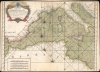
1764 Roux Maritime Map or Chart of the Western Mediterranean Sea


This item has been sold.
Carte de la Méditerranée dediée à Mgr le duc de Choiseul...
Unrecorded, Likely Pirated Chart of the Mediterranean.
Choose a Collection:
- Digital Map Information
- Suitable for large format printing
- Full resolution TIFF file
- ICC color profile embedded
- Delivered instantly via download link
This Item
Enquire
Unrecorded, Likely Pirated Chart of the Mediterranean.
This is a rare and likely pirated nautical chart or map of the western Mediterranean Sea, based on Joseph Roux's 1764 groundbreaking 'Carte de la Mer Méditerranée en douze feuilles'. Roux's work was highly sought after and considered the gold standard for navigating the Mediterranean into the early 19th century.A Closer Look
The chart covers the western part of the Mediterranean Sea, from the Strait of Gibraltar to the Adriatic Sea, covering the coasts of both Europe and Africa. Ports, islands, and coastal features like capes and bays are labeled throughout, while multiple compass roses and rhumb lines provide essential information for setting courses. Hazards, shoals, islets, and other important navigational information are also included. Four scales are provided at the bottom left.The Influence of Roux's Mediterranean Charts
Joseph Roux's hydrographic work during the mid-18th century fundamentally reshaped Mediterranean navigation. Working as the 'Hydrographe du Roy' from his family's prominent hydrographic and maritime shop in Marseille, Roux published his magnum opus in 1764, the 'Carte de la Mer Méditerranée en douze feuilles'. This detailed 12-sheet chart mapped the basin's complex coastlines with unprecedented precision, providing vital details on shoreline depths, ports, sandbars, and anchorage points. To complement his massive wall-sized map, Roux also published a highly popular, pocket-sized companion handbook, the Recueil des principaux plans des ports et rades de la mer Méditerranée. Extracted directly from the 12-sheet masterpiece, this portable atlas underwent numerous editions and remained the gold standard for merchants, privateers, and naval officers navigating the Mediterranean corridors well into the 19th century. Roux's work was later incorporated into the grand official naval compilations of Jacques-Nicolas Bellin (particularly his Atlas Maritime), the chief cartographer of the French Navy, and became the standardized geographical baseline for navigating Mediterranean waters for decades, which led to widespread pirating of Roux's charts. The strategic and scientific value of Roux's chart was so high that even French adversaries relied on it; most famously, Admiral Horatio Nelson kept a copy of Roux's 12-sheet map (now held at the National Maritime Museum in Greenwich) aboard his flagship, HMS Victory, during the Napoleonic Wars (1803 - 1815).Publication History and Census
The present chart is attributed to Joseph Roux, having been engraved by 'Laurent fils' and dated 1764. It is undoubtedly derived from his 'Carte de la Mer Méditerranée en douze feuilles' but combines elements from multiple sheets (see Rumsey 2936). It also does not correspond to the presentation of Roux's charts that appeared in Bellin's Atlas Maritime or in Roux and Bellin's other works. Indeed, we have been unable to locate any other examples of a map with this presentation and title (Carte de la Méditerranée versus Carte de la Mer Méditerranée…) in institutional collections or market history. It appears to have been a separate issue, very possibly unauthorized (i.e., pirated), meant to meet the demand of mariners for the latest and greatest navigational information.Condition
Average. Soiling. Trimmed into top border and bottom border mostly absent. Closed margin tears professionally repaired on verso. Printer's crease on left side.