1943 Minneapolis Morning Tribune Map of Europe and the Mediterranean
MediterraneanCitadel-vanswearingen-1943$200.00

Title
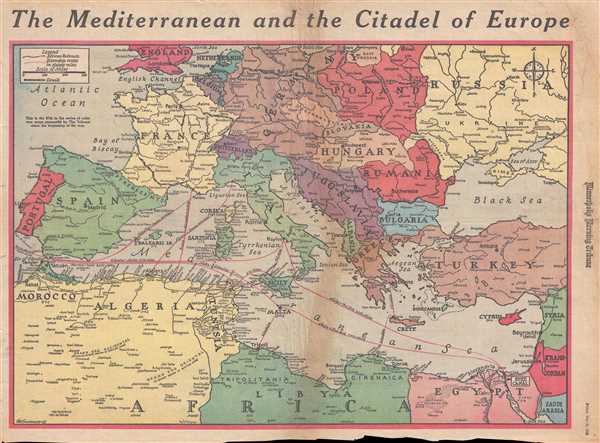
The Mediterranean and the Citadel of Europe.
1943 (dated) 15.5 x 21.75 in (39.37 x 55.245 cm) 1 : 8448000
1943 (dated) 15.5 x 21.75 in (39.37 x 55.245 cm) 1 : 8448000
Description
This is a Friday, May 21, 1943 Van Swearingen and Minneapolis Morning Tribune map of Europe and the Mediterranean a week after the surrender of Italian and German forces in North Africa on May 13, 1943. The map depicts the region from England, the North Sea, and Germany to North Africa and from the Atlantic Ocean, Portugal, Spain, and Morocco to the Black Sea, Turkey, Syria and Transjordan. As this map was published eight days after the surrender of Axis forces in North Africa, it is presenting the current situation of the war against Nazi Germany and Fascist Italy to the Tribune's readers. Since combat in North Africa had ended, the world's focus was now turned toward where the Allies would invade 'the Citadel of Europe'. Here, Van Swearingen takes the approach that the Allies would utilize territory gained in North Africa to launch their assault on Europe and gives distances from many Allied occupied cities and islands to possible invasion sites across southern Europe. Although unknown at the time, the Allies chose Sicily as their next objective, and launched an amphibious and airborne invasion on July 10, 1943, seven weeks after this map was printed.
A well-made map, all the countries illustrated are labeled, along with myriad cities and towns throughout Europe, the Middle East, and North Africa. These include major cities, such as Rabat, Casablanca, Algiers, Tunis, Tripoli, and Tobruk in North Africa (all of which played a role in the North African campaign), Jerusalem, Tel Aviv, Haifa, and Beirut in the Middle East, and all of the major capitals of Europe. The line dividing Poland between Germany and Russia established by the Molotov-Ribbentrop Pact of 1939 is also illustrated, although the current battle line between the Germans and the Russian is not. Rail lines in North Africa are illustrated, along with canals in Europe.
This map was drawn by Van Swearingen and published as the 97th map in the series of color war maps published by the Minneapolis Tribune on Friday, May 21, 1943.
Cartographer
The Minneapolis Tribune (1867 - present) was founded by Colonel William S. King, William D. Washburn, and Dorilus Morrison and the first issue was published on May 25, 1867. In 1941, the Cowles family of Des Moines, Iowa bought the Tribune and merged it with their other holdings in Minneapolis, giving the Cowles family ownership of all the city's major newspapers. The Tribune became the city's morning newspaper, and the Star-Journal was the evening newspaper. The two published a joint Sunday edition. The newspaper is still published today, under the name Star Tribune. More by this mapmaker...
Condition
Good. Newsprint. Even overall toning. Closed tears along top, bottom, and left margins. Soiling along top and right margins. Soiling and wear along original centerfold. Text on verso.