This item has been sold, but you can get on the Waitlist to be notified if another example becomes available, or purchase a digital scan.
1822 William Heather and John Norie Nautical Chart of the Eastern Mediterranean
MediterraneanSeaEast-heather-1822$500.00

Title
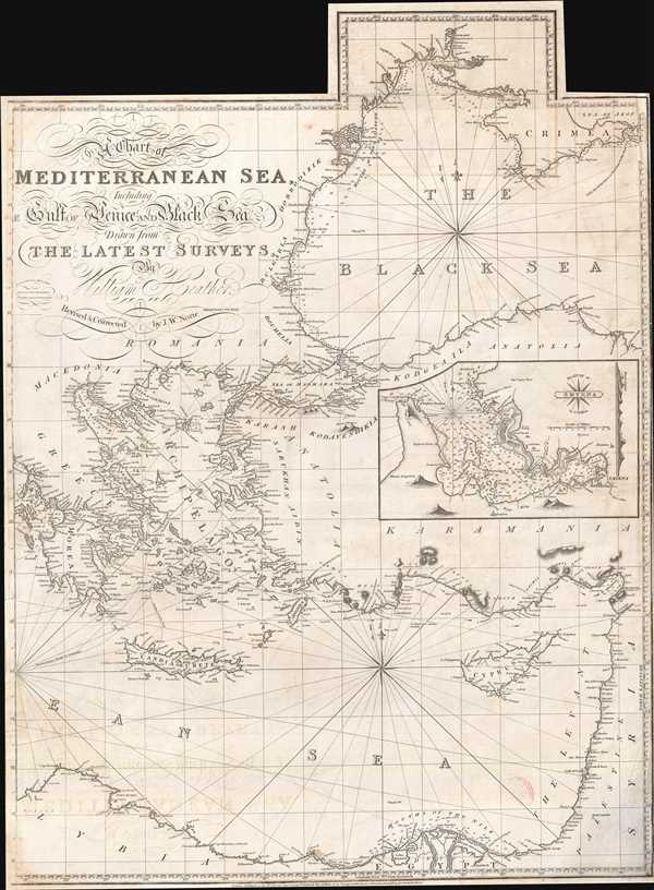
A Chart of the Mediterranean Sea, Including the Gulf of Venice and Black Sea.
1822 (dated) 35 x 25.5 in (88.9 x 64.77 cm) 1 : 2300000
1822 (dated) 35 x 25.5 in (88.9 x 64.77 cm) 1 : 2300000
Description
A dramatic 1822 nautical chart of the eastern part of the Mediterranean Sea by William Heather and John Norie. This map was first issued by William Heather's Navigation Warehouse and Naval Academy in 1812. The original map covered the entire Mediterranean on three sheets, of which this is the easternmost panel. The panel's were intended to be joined, or as here used as stand-alone charts. The present example covers from the Ionian Islands to modern day Israel and from the Crimea to the Nile Delta, encapsulating all of modern-day Greece, the western Black Sea, Cyprus, much of modern day Turkey, the Balkans, Israel and Lebanon, and northern Egypt. A detachable flap extends coverage of the Black Sea northwards as far as Odessa. An inset map details the harbor of Smyrna, or modern-day Izmir, Turkey.
Blueback Charts
Blueback nautical charts began appearing in London in the late 18th century. Bluebacks, as they came to be called, were privately published large format nautical charts known for their distinctive blue paper backing. The backing, a commonly available blue manila paper traditionally used by publishers to warp unbound pamphlets, was adopted as a practical way to reinforce the low-quality paper used by private chart publishers in an effort to cut costs. The earliest known blueback charts include a 1760 chart issued by Mount and Page, and a 1787 chart issued by Robert Sayer. The tradition took off in the early 19th century, when British publishers like John Hamilton Moore, Robert Blachford, James Imray, William Heather, John William Norie, Charles Wilson, David Steel, R. H. Laurie, and John Hobbs, among others, rose to dominate the chart trade. Bluebacks became so popular that the convention was embraced by chartmakers outside of England, including Americans Edmund March Blunt and George Eldridge, as well as Scandinavian, French, German, Russian, and Spanish chartmakers. Blueback charts remained popular until the late 19th century, when government subsidized organizations like the British Admiralty Hydrographic Office and the United States Coast Survey, began issuing their own superior charts on high quality paper that did not require reinforcement.Publication History and Census
Heather's original map was updated in the present example by his student John Norie, to reflect the most current information as of 1822.CartographerS
William Heather (1793 – 1812) was a British nautical chart engraver and publisher active in the late 18th and early 19th centuries. Heather was born in Lambeth but shortly after relocated with his family to the parish of Christ Church, Southwark. He was apprenticed to George Michell, a London stationer. Heather reached his maturity and became a member of the Stationers Company in 1789. His earliest known cartographic work appeared in conjunction with the offices of John Hamilton Moore, with whom he was employed. Around 1793 Heather started his own competing nautical chart business at 157 Ledenhall Street, London. This office remained the home of his firm for an astounding 85 years. Heather soon took on the Scotsman John William Norie as an apprentice Norie eventually inherited Heather's business and map plates, beginning his own long career as a maker of English blueback charts. More by this mapmaker...
John William Norie (June 3, 1772 - December 24, 1843) was a British teacher of navigation, hydrographer, chart maker, and publisher of maritime manuals active in London, England in the late 18th and early 19th centuries. Norie was born in Wapping, London, an area long associated with the maritime sciences. Norie's career as a chart maker commenced under the tutelage of William Heather, a prominent purveyor and publisher of nautical charts, pilot books, and navigational tools who took over the firm of Mount and Page in 1765. Heather and Norie were likely acquainted through John Hamilton Moore, another important chart maker with whom both seem to have been associated early in their careers. Heather hired Norie to teach basic navigation at his shop at 157 Leadenhall Street. Under Heather Norie also distinguished himself as a draftsman, completing many of the early charts associated with the Heather firm. When Heather died in 1812 John Norie partnered with George Wilson, a moneyed 'man about town' with little experience in the maritime trades, to acquire the map and chart business at 9500 British Pounds. It proved a good deal for Norie, who retained all copyright privileges and drew 1/4 quarter share of business profits, as well an impressive quarterly salary and, for doing all of the work, 1/3rd of Wilson's share. The firm, referred to as the 'Naval Warehouse' quickly acquired a reputation for quality navigational materials and became a favorite of merchant seamen. It was even referenced in Charles Dickens' classic novel Dombey and Son. In 1819, Norie and Wilson acquired the failing chart business of David Steel, which significantly increased the size, though not quality, of their chart catalogue. With the rise of the British Admiralty and its own maritime chart productions, the business of "Chart Purveyor" in London dramatically changed. Admiralty charts and pilot books, designed for military use, were offered through established intermediaries, like Norie, at bargain prices. Most chart makers of the period found it profitable to use the highly technical Admiralty charts to update their own more decorative vernacular charts. For a brief time this practice proved exceptionally profitable but eventually began to draw criticism. Nonetheless, Norie retired to Edinburgh in 1840 and died a wealthy man in 1843. In 1840 the business passed to a nephew of George Wilson, Charles Wilson, who renamed the firm "Norie & Wilson". William Heather Norie, J. W. Norie's own son, produced few charts, instead pursuing a career in the legal field. Norie & Wilson merged with James Imray's prosperous chart business in 1899, becoming Imray, Laurie, Norie & Wilson, a profitable concern that remains active in the maritime charting industry. Learn More...
Condition
Good. Minor loss and restoration, right margin. Old library stamp lower right quadrant. Verso reinforcement here and there.
References
OCLC 43589121.