1847 Brown and Parsons Map of Maine, New Hampshire, and Vermont
MENHVT-brownparsons-1847$1,250.00


Title
Map of Maine New Hampshire and Vermont, From the most authentic Sources.
1847 (dated) 14.5 x 19.5 in (36.83 x 49.53 cm) 1 : 1013760
1847 (dated) 14.5 x 19.5 in (36.83 x 49.53 cm) 1 : 1013760
Description
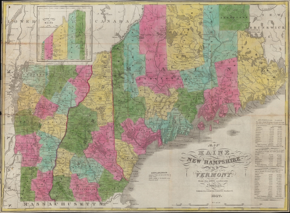
This is an 1847 pocket map of Maine, New Hampshire, and Vermont published by Brown and Parsons. Among other features, it demonstrates the demographic, territorial, and infrastructural development of the states since the founding of the United States.
An inset map in the upper left illustrates northern Maine. The vastly larger size of Maine compared to its smaller neighbors is obscured by the reduced scale of the inset, but as the statistical table at bottom-right makes clear, the area of the state nearly doubled that of Vermont and New Hampshire combined.
The table lists the population and area of the states, including the 1810 and 1820 statistics. Underneath, census data for 1790 and 1800 is included for comparison (1790 and 1810 in the case of New Hampshire). These figures demonstrate the rapid growth of northern New England in the decades after independence - New Hampshire's population nearly doubled between 1790 and 1820, while Vermont's more than doubled and Maine's more than tripled.
In any edition, the map is scarce to the market.
A Closer Look
Cities and towns throughout are identified, along with the ever-growing road network. The region's best-known lakes, including Winnipesaukee, Moosehead, and Champlain, are depicted, as well as many rivers and mountains. Beautiful original color differentiates counties. Updates reflect changes over earlier editions (see below); for example, Piscataquis County in Maine has been included here as it was founded in 1838.An inset map in the upper left illustrates northern Maine. The vastly larger size of Maine compared to its smaller neighbors is obscured by the reduced scale of the inset, but as the statistical table at bottom-right makes clear, the area of the state nearly doubled that of Vermont and New Hampshire combined.
The table lists the population and area of the states, including the 1810 and 1820 statistics. Underneath, census data for 1790 and 1800 is included for comparison (1790 and 1810 in the case of New Hampshire). These figures demonstrate the rapid growth of northern New England in the decades after independence - New Hampshire's population nearly doubled between 1790 and 1820, while Vermont's more than doubled and Maine's more than tripled.
Publication History and Census
This map is based on an 1834 map by Hiram F. Sumner, which itself was based on an 1826 pocket map by Anthony Finley. Sumner's business was later purchased by Flavius Brown, who in 1837 became business partners with Edward W. Parsons, leading to this map in 1847. The OCLC notes three other editions of this map from 1841, 1845, and 1849 (undated but presumed), held by Stanford University, the American Antiquarian Society, the University of Houston, the University of Wisconsin - Milwaukee, the Connecticut State Library, Brown University, and the University of Southern Maine. The David Rumsey Map Collection includes examples dated 1838 and 1847.In any edition, the map is scarce to the market.
CartographerS
Flavius A. Brown (August 31, 1806 - February 13, 1880) was an educator, politician, and publisher based in Hartford, Connecticut. Born in Hebron, Connecticut, Brown became renowned at a young age for his penmanship and by age 16 had become a teacher. After helping to construct a new schoolhouse in Hartford, which came to bear his name, Brown served as the chairman of the city's First School District for many years afterwards. He took on other roles in the community, including as secretary of the Hartford County Agricultural Society, and in business, serving as the director of several banks and insurance companies. He was elected Treasurer of Hartford in 1857. His career in publishing began with a business partnership with buying out the H.F. Sumner and Company bookstore in 1834, renamed Packard and Brown, and in 1837 renamed again to Brown and Parsons (Edward W. Parsons). Parsons retired in 1852 and Brown took on one W. Gross as a partner until he stepped back to focus on other pursuits from 1858. Still, the name Brown and Gross continued to be used and it remained a prominent publisher into the late 19th century. More by this mapmaker...
Hiram Frederick Sumner (February 14, 1800 - March 3, 1874) was an American publisher and bookseller. Born in Hebron, Connecticut, Sumner founded H.F. Sumner and Company in 1830. Flavius A. Brown (a former Sumner employee) and Caleb M. Packard bought out the H.F. Sumner and Company bookstore at 20 State Street in Hartford, Connecticut in 1834, and operated it as Packard and Brown for three years. Packard retired in 1837 and E.W. Parsons joined the firm, which was renamed Brown and Parsons. Brown and Parsons remained at the State Street location until 1844. Very little else is known about Sumner's professional life after the sale of H.F. Sumner and Company. Sumner married Caroline G. Conant (1811 - 1883) on August 22, 1830, with whom he had three children. Learn More...
Condition
Good. Wear along original fold lines. Verso repairs to fold separations and at fold intersections. Small areas of infill at a few fold intersections. Closed tear extending 1.5 inches through printed area in Chittenden County, New Hampshire repaired on verso. Reinforced where once attached to original binder.
References
Rumsey 2336.002 (1838 edition), 4395.002 (1847 edition); OCLC 953568631, 905078463, 794856182.