This item has been sold, but you can get on the Waitlist to be notified if another example becomes available, or purchase a digital scan.
1786 Tofino Nautical Chart or Map of Menorca or Minorca, Spain
Menorca-tofnio-1786$1,250.00

Title
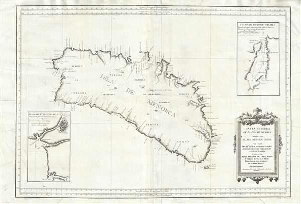
Carta Esférica de las Isla de Menorca; Presentada al Rey Nuestro Señor.
1786 (dated) 35 x 24 in (88.9 x 60.96 cm) 1 : 81300
1786 (dated) 35 x 24 in (88.9 x 60.96 cm) 1 : 81300
Description
An extremely rare large scale 1786 Spanish nautical chart detailing the Balearic Island of Menorca (Minorca) by the famed hydrographers Vincente Tofiño de San Miguel and Antonio Valdés y Fernández Bazán. The map covers the island in full with light shoreline detail and soundings along the coasts. An inset map the lower left details the port city of Ciutadella de Menorca. The walled fortress city and streets are evident. Soundings continue up the river. A second inset appears in the upper right and details the northern port of Fornells. The map is beautifully engraved with villages represented by tiny finely etched illustrations. A rococo title cartouche appears in the lower right quadrant.
At the command of Valdés, Tofiño surveyed the Balearic Islands between 1783 and 1788. The results of their work appear to have been issued first independently then bound into various composite nautical atlases from about 1788. The present map was engraved by J. Joacqin Fabregat.
At the command of Valdés, Tofiño surveyed the Balearic Islands between 1783 and 1788. The results of their work appear to have been issued first independently then bound into various composite nautical atlases from about 1788. The present map was engraved by J. Joacqin Fabregat.
CartographerS
Vincente Tofiño de San Miguel (September 6, 1732 - 1795) was a Spanish naval officer and hydrographer active in the second half of the 18th century. Tofiño was born in Cadiz, Spain. His father, a career army officer, died in the 1746 Battle of Placentia, leaving Vincente an orphan from age 14. He moved to Extremadura where his uncle, a priest, raised him. In 1750, following in his father's footsteps, he joined the army. Having discovered a proficiency in mathematics, Tofiño was assigned to an artillery unit. In 1755, moving from the army to the navy, where his skills were better suited, he became a professor of mathematics at the Academia de Guardia Marinas de Cádiz. He would remain in the navy for the subsequent 30 years, ultimately attaining the rank of Rear Admiral. Between 1783 and 1788, as a navy officer, astronomer, and hydrographer, he was deployed to survey the Mediterranean ports of Spain, the Balearic Islands, and the Barbary Coast. He trained the explorers Dionisio Alcalá Galiano and Cayetano Valdés y Flores Bazán, who named Tofino Inlet, in Vancouver, after him. Tofiño was elected correspondent of the Spanish Academy of History and of the French and Portuguese Academies of Science. He died in Cadiz in 1795. More by this mapmaker...
Antonio Valdés y Fernández Bazán (1744 – April 4, 1816) was a Spanish naval officer active in the latter part of the 18th century. He was born In Burgos, Spain, and entered the navy at age 13. He distinguished himself in the defense of Morro Castle and San Salvador de la Punta Fortress during the Battle of Havana (1762). He also fought against the Barbary Coast pirates in 1767. In 1781, he became director of the Royal Artillery Factory of La Cavada, and reorganized it to that extent that he was promoted to become inspector general of the Spanish Navy. In 1783, at the age of 38, he became Navy Minister and continued the modernization of the Spanish Navy. He became a knight in the Order of the Golden Fleece in 1797. His nephew, the explorer Cayetano Valdés y Flores, named Valdez, Alaska and Valdez, Florida, after him. Learn More...
Source
Tofiño de San Miguel, V., Derrotero dea la Costas de España en el Mediterraneo, y su correspondiente de Africa… (Madrid) 1787.
Condition
Very good. Minor wear and some minor creasing.
References
OCLC 733638512. Biblioteca Nacional de España, GMG/122 MAPA 11.