This item has been sold, but you can get on the Waitlist to be notified if another example becomes available, or purchase a digital scan.
1897 Merchants Association of New York Certificate and New York City View
MerchantsAssociationCert2-colton-1897$1,750.00

Title
The Merchants' Association of New York.
1897 (dated) 16 x 23 in (40.64 x 58.42 cm)
1897 (dated) 16 x 23 in (40.64 x 58.42 cm)
Description
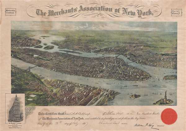
An extraordinary unique find, this is an original 1897 membership certificate for the Merchants' Association of New York. The certificate was issued for one A. e. Sinauton (sp?), a class B non-resident member of the association, number 166. The Merchants' Association of New York was founded in 1897 to further and develop commerce in and around New York City. The association also engaged in political lobbying, charitable works, and encouraged ethical business practices among its members. The Merchant's Association had two classes of membership, Class A, issued to full time business active in New York City, and Class B, issued to non-resident businesses active outside of New York City. The certificate bears the signatures of Charles J. Root, the organization's secretary and William F. King, its first president. The associations red-orange corporate seal is set in the lower right quadrant.
The centerpiece of the certificate is a magnificent areal or birds-eye view of New York City by G. W. and C. B. Colton. Presented in chromolithograph color this view reveals Manhattan, Brooklyn, and Queens as seen from high above Jersey City and Hoboken, which themselves appear in the lower left quadrant. The area covered runs from the Bronx to the Statue of Liberty and from Hoboken to Brooklyn and Governor’s Island.
The map is presented as if looking west from high above Hoboken and Jersey City – an unusual take on the city which deviates considerably from the more common south-north Manhattan views by earlier publishers such as Currier and Ives, and others. This might be explained by the development of Upper Manhattan, most notably the Upper West Side and Central Park, late in second half of the 19th century. The artist would have wanted to represent these newly affluent areas so that his view would appeal to the widest possible audience.
Several bridges are noted including the Brooklyn Bridge (completed in 1883), the Williamsburg Bridge (opened in 1903 but under construction as this view was being drawn), the Queensboro Bridge (proposed but, as this map was being drawn, as not as yet under construction), and a curious bridge that never materialized crossing the Hudson to Hoboken at 59th Street. Central Park is clearly visible, as are the Statue of Liberty in the lower right quadrant, St. John the Divine in the upper left, and Brooklyn’s Prospect Park in the upper right. New York’s signature grid system is clearly represented as are many individual buildings, many of which still stand today. The rivers, and harbor are teaming with life as countless ships of all shapes and sizes visit the many wharves on both size of the River. Smoke escapes many chimneys throughout, though especially in lower Manhattan and Jersey City, giving evidence to New York City’s bustling late 19th century industry.
Original Merchant's Association of New York Certificates are extremely rare, the present offering being one (and vastly the superior) of only two known examples. The other is held in the collections of the Star of the Republic Museum in Washington-on-the-Brazos, Texas. While we can assume that these certificates were issued in volume, their extreme rarity is accounted for by the fact that the Merchants' Association aggressively recalled all of its original certificates in June of 1913 in exchange for a new, redesigned certificate. Most examples of the Merchants' Association's original founding certificates were thus destroyed.
It is noteworthy that Geographicus is also currently offering the only known example of the original Colton proof on which this reduced view is based. See Geographicus item: NewYorkCityView-colton-1897.
Cartographer
Joseph Hutchins Colton (July 5, 1800 - July 29, 1893), often publishing as J. H. Colton, was an important American map and atlas publisher active from 1833 to 1897. Colton's firm arose from humble beginnings when he moved to New York in 1831 and befriended the established engraver, Samuel Stiles. He worked under Stiles as the 'Co.' in Stiles and Co. from 1833 to 1836. Colton quickly recognized an emerging market in railroad maps and immigrant guides. Not a cartographer or engraver himself, Colton's initial business practice mostly involved purchasing the copyrights of other cartographers, most notably David H. Burr, and reissuing them with updated engraving and border work. His first maps, produced in 1833, were based on earlier Burr maps and depicted New York State and New York City. Between 1833 and 1855, Colton proceeded to publish a large corpus of guidebooks and railroad maps, which proved popular. In the early 1850s, Colton brought his two sons, George Woolworth Colton (1827 - 1901) and Charles B. Colton (1832 - 1916), into the map business. G. W. Colton, trained as a cartographer and engraver, was particularly inspired by the idea of creating a large and detailed world atlas to compete with established European firms for the U.S. market. In 1855, G.W. Colton issued volume one of the impressive two-volume Colton's Atlas of the World. Volume two followed a year later. Possibly because of the expense of purchasing a two-volume atlas set, the sales of the Atlas of the World did not meet Colton's expectations, and so, in 1856, the firm also issued the atlas as a single volume. The maps contained in this superb work were all original engravings, and most bear an 1855 copyright. All of the maps were surrounded by an attractive spiral motif border that would become a hallmark of Colton's atlas maps well into the 1880s. In 1857, the slightly smaller Colton's General Atlas replaced the Atlas of the World. Most early editions of the General Atlas published from 1857 to 1859 do not have the trademark Colton spiral border, which was removed to allow the maps to fit into a smaller format volume. Their customers must have missed the border because it was reinstated in 1860 and remained in all subsequent publications of the atlas. There were also darker times ahead; in 1858, Colton was commissioned at a sum of 25,000 USD by the government of Bolivia to produce and deliver 10,000 copies of a large format map of that country. Although Colton completed the contract in good faith, delivering the maps at his own expense, he was never paid by Bolivia, which was at the time in the midst of a series of national revolutions. Colton would spend the remainder of his days fighting with the Bolivian and Peruvian governments over this payment, and in the end, after a congressional intervention, he received as much as 100,000 USD in compensation. Nonetheless, at the time, it was a disastrous blow. J. H. Colton and Company is listed as one of New York's failed companies in the postal record of 1859. This led Colton into the arms of Alvin Jewett Johnson and Ross C. Browning. The 1859 edition of Colton's General Atlas lists Johnson and Browning as the 'Successor's to J. H. Colton' suggesting an outright buyout, but given that both companies continued to publish separately, the reality is likely more complex. Whatever the case may have been, this arrangement gave Johnson and Browning access to many of Colton's map plates and gave birth to Johnson's New Illustrated (Steel Plate) Family Atlas. The Johnson's Atlas was published parallel to Colton's atlases well into the 1880s. The Colton firm itself subsequently published several other atlases including an Atlas of America, the Illustrated Cabinet Atlas, the Octavo Atlas of the Union, and Colton's Quarto Atlas of the World. They also published a large corpus of wall maps, pocket maps, and guides. The last known publications of the Colton firm date to 1897 and include a map and a view, both issued in association with the Merchant's Association of New York. Alice M. Colton married August R. Ohman (May 3, 1859 - April 22, 1934) on January 5, 1897. In 1898, Ohman joined the Colton firm, which continued to publish as Colton, Ohman & Co. until 1901. More by this mapmaker...
Condition
Very good. Light toning. Light soiling. Blank on verso.
References
Star of the Republic Museum, LOCAL-CONT-NO: 1969-239.28. Greater New York: Bulletin of the Merchants' Association of New York', Volume 2, June 9, 1913, page 12. New England Stationer and Printer, Volume 11, page 4.