This item has been sold, but you can get on the Waitlist to be notified if another example becomes available, or purchase a digital scan.
1889 French Nautical Chart or Map of the Red Sea
MerRouge-elwonmoresby-1889$225.00

Title
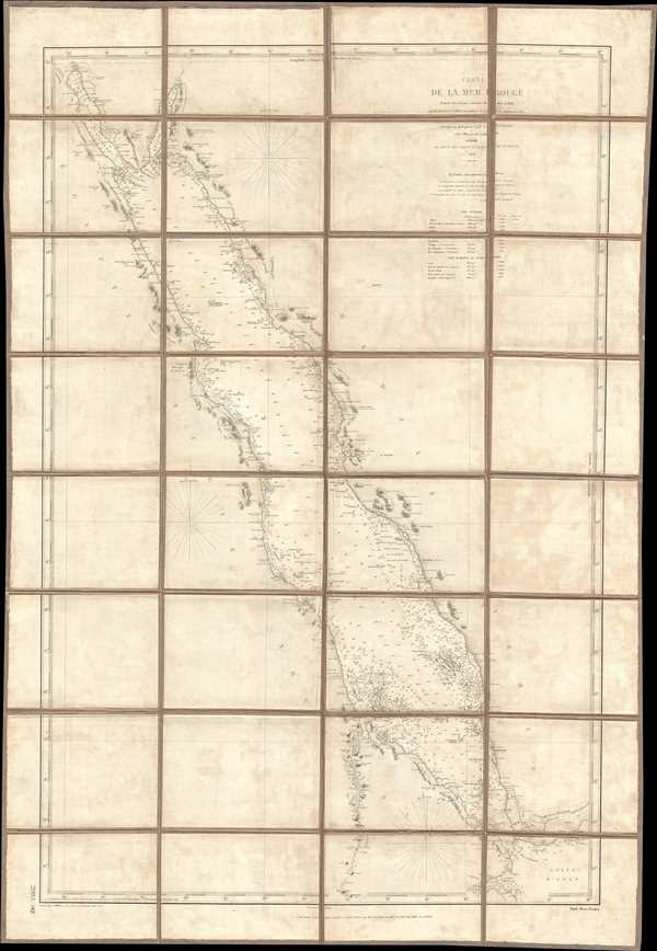
Carte de la Mer Rouge d'après les travaux exécuté de 1830 à 1834 par M.M. Elwon et Moresby, Officier de la Marine Anglaise des Indes, Corrigés en 1858 par le Capne. W.J.S. Pullen et les Officiers du Cyclops.
1889 (dated) 41 x 28.25 in (104.14 x 71.755 cm) 1 : 2540000
1889 (dated) 41 x 28.25 in (104.14 x 71.755 cm) 1 : 2540000
Description
This is an 1889 French edition of a navigational chart or map of the Red Sea produced from surveys executed by Commander Thomas Elwon and Lieutenant Robert Moresby between 1830 and 1834. Elwon and Moresby were members of the English Indian Navy, formerly known as the Bombay Marine, the navy of the British East India Company. The chart depicts the Red Sea from Suez to the Gulf of Aden and from Egypt, Sudan (Nubie), and Eritrea and Djibouti (Abyssinie) to Saudi Arabia (Hedjaz) and Yemen. Highly detailed, myriad depth soundings are indicated and given in meters. Numerous islands, reefs, and shoals are depicted, including Daedalus Shoal. Cities are labeled, including Mecca (La Mecque), Medina (Medine), Suez, Aden, and several smaller cities and towns. Mountains are presented along both coast lines, some of which are labeled and others include elevations
The survey of the Red Sea undertaken by Elwon and Moresby happened because of an increased desire to improve communications between Britain and India. The Suez Canal, which links the Mediterranean Sea and the Red Sea, would not be completed until 1869. In the 1830s, an Overland Route was used. Elwon and Moresby spent four years meticulously executing their survey, although the hazards of the Red Sea took their toll on their ships. On several occasions, either Elwon's or Moresby's ship had to return to India to be refitted due to damage, delaying work for months at a time. Ultimately, Elwon and Moresby finished their work.
This map was engraved by J. Millian and published in 1889 at the Dépot des Cartes et Plans de la Marine in Paris.
Condition
Very good. Dissected and mounted on linen in 32 panels. Original linen in good condition.
References
OCLC 965448932.