1915 British War Office of Iran and Iraq
Mesopotamia-waroffice-1915$3,500.00


Title
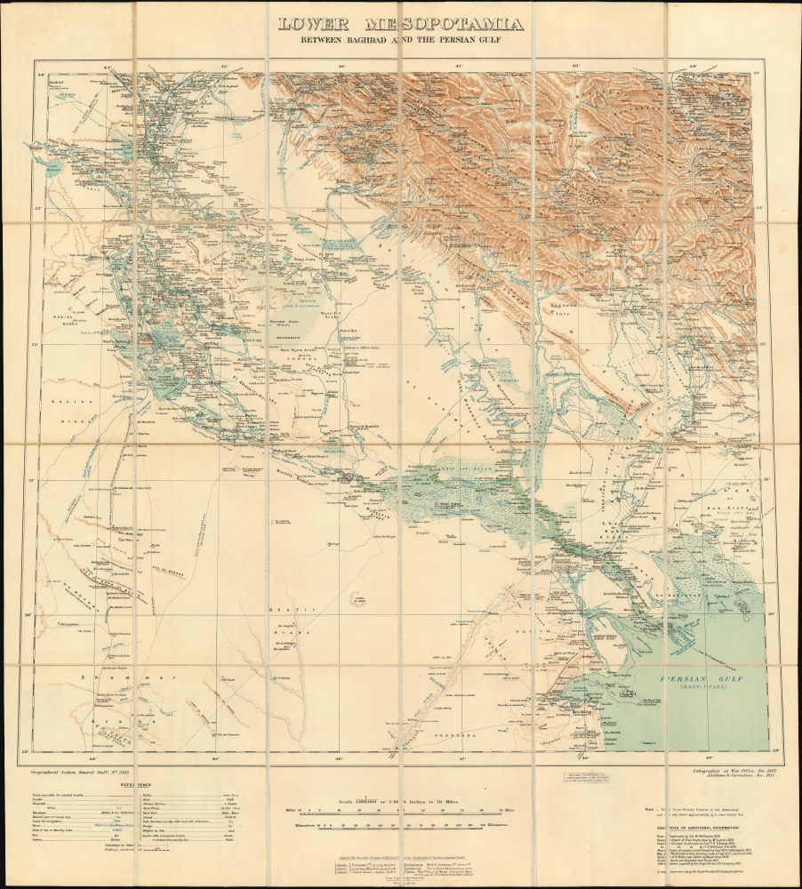
Lower Mesopotamia Between Baghdad and the Persian Gulf.
1915 (dated) 28 x 26 in (71.12 x 66.04 cm) 1 : 1000000
1915 (dated) 28 x 26 in (71.12 x 66.04 cm) 1 : 1000000
Description
This is a 1915 updated edition of the British War Office map of Lower Mesopotamia, the authoritative map of Central and Southern Iraq, Kuwait and Khuzestan (Iran) employed by both sides in the First World War. First surveyed and printed in 1907, it was the first accurate general map of the region.
Gerard and Charles became granduncles of English actress Helena Bonham Carter.
A Closer Look
The map details the Euphrates and Tigris watershed, predominantly central and southern Iraq from Baghdad to Basra and the Persian Gulf, including most of Kuwait and the Khuzestan Province in southwestern Persia. This was mostly Ottoman territory at the beginning of the World War I (1914 - 1918), with Kuwait as a British protectorate. Southern Persia was a British zone of influence - based on the interests of the Anglo-Persian Oil Company.Oft Updated and Pirated
The map was be updated by the British War Office in June 1911, December 1915 (this example,) 1916, and 1919. So excellent was this cartography that it was pirated twice by the German military: first in 1915 based on the British 1911 edition, and then in 1917 based on the British 1916 edition. It would not be the first time that combatants would go to war armed with the same maps, but it is nevertheless a remarkable instance of the phenomenon.Preparing for War
The 1911 and 1915 editions are cartographically near identical, except that the 1915 has been updated with measurements for the heights of the banks along the Tigris and the Shatt-al-Arab: earlier versions have the measurements in meters, but here they have been recalibrated in feet. Since the British campaign in Mesopotamia was based on a foothold in Basra, and was aimed at the capture of Baghdad, the route presented by these two waterways was significant both for the movement of troops and for resupply, and knowledge of the height of the banks at different points was crucial.The German Edition
At some point in 1915, the Cartographic Service of the General Staff of the German Army in Berlin produced a pirated edition of the 1911 edition of this map, and it - like the British edition it copied - would have been the best general map available to officers engaged in the theatre. Although the actual troops facing Britain during the campaign were Ottoman, the Germans actively guided and armed the Turkish side, and indeed the army defending Baghdad at the end of 1915 was commanded by the Prussian Colmar Von der Goltz, who commanded the successful Ottoman-German defense at the Battle of Battle of Ctesiphon (November 22-25, 1915), and who would besiege and ultimately capture the British army at the Siege of Kut-al-Amara (December 7, 1915 April 29, 1916).Time To Improve The Map
It is in the context of this discouraging (for the British) turn of events that the present, December 1915 edition of the map was prepared. Throughout the defeat at Ctesiphon and the Siege of Kut, the main British difficulty was resupply. Scrutiny of the map will show that between Basra and Kut there were no rail lines or suitable rads; the terrain by land is characterized by marshland prone to flooding. Thus, this map's resurvey and more granular measurement of the rivers and their banks - the only promising route for keeping the British army at Kut in communication. (It wasn't enough.)Captain G. Bonham Carter
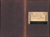
This example of the map was bound and sold by Stanfords' (and resold by Hugh Rees in London). The label on the covers bears the owners' name, unit, and date: 'Captain G. (Gerard) Bonham Carter 3rd Bn. Royal West-Kent Regt., May 1916.' The third battalion of the Royal West Kent regiment was a Garrison unit, stationed in the home counties during the war. Bonham Carter's brother Charles (later General Sir Charles), however, had been in the 2nd Battalion of the same unit, and they were deployed in Mesopotamia from 1915 until the end of the war and would have been active in the campaigns there. In fact, two companies of the 2nd Battalion were among those captured at the siege of Kut. While it does not appear that Sir Charles was among those captured, Gerard would have had a familial connection to reinforce his solidarity with the 2nd Battalion of his own unit (which he would himself be likely to be assigned to, should he have been posted overseas.)Gerard and Charles became granduncles of English actress Helena Bonham Carter.
Publication History and Census
The 1919 edition of the map is well represented in OCLC, followed by the 1911. We do not see an example of the 1907 in institutional collections, and only one example of this 1915 revision is catalogued, residing at the University of California at Berkeley.CartographerS
The British War Office (1857 - 1964) was a department of the British Government responsible for the administration of the Royal Army until 1964, when its functions were transferred to the Ministry of Defense. The War Office was to the Royal Army what the Admiralty was to the Royal Navy, and later, the Air Ministry. Within the War Office, the General Staff Topographical Section was responsible for thousands of maps issued for British intelligence and military use. The Topographical Section was renamed Geographical Section in April 1907. Many, once their military use passed, were offered through licensed agents to the general public. The sole London agent for War Office material was Edward Stanford. More by this mapmaker...
The British War Office (1857 - 1964) was a department of the British Government responsible for the administration of the Royal Army until 1964, when its functions were transferred to the Ministry of Defense. The War Office was to the Royal Army what the Admiralty was to the Royal Navy, and later, the Air Ministry. Within the War Office, the General Staff Topographical Section was responsible for thousands of maps issued for British intelligence and military use. The Topographical Section was renamed Geographical Section in April 1907. Many, once their military use passed, were offered through licensed agents to the general public. The sole London agent for War Office material was Edward Stanford. Learn More...
Condition
Excellent. Dissected and mounted on linen as issued; original boards removed but present.
References
OCLC 227505504.