1954 Jacques Branger Pictorial Map of Asia (Messageries Maritimes)
MessageriesMaritimes-branger-1954$350.00

Title
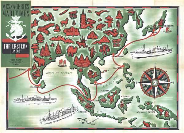
Messageries Maritimes Far Eastern Liners
1954 (undated) 21.5 x 28.5 in (54.61 x 72.39 cm) 1 : 13500000
1954 (undated) 21.5 x 28.5 in (54.61 x 72.39 cm) 1 : 13500000
Description
This is a 1954 Jacques Branger pictorial map advertising Messageries Maritimes' route through East Asia. The map depicts Asia from India to Japan and New Guinea and from Mongolia and Korea to extreme northern Australia. This map highlights the three newly-christened ships which serve the Indo-Chinese and Far East market, the Cambodge (French for Cambodia), the Laos, and the Viet-Nam. The month long voyages began at Marseille, and then called at Port Said and Aden (which are not on the map), then at Bombay, Colombo, Singapore, Saigon, Hong Kong, Kobe (only on the eastbound voyage), and Yokohama. Numerous vignettes decorate the map, including Angkor Wat, a woman in traditional Thai dress, a Chinese dragon, an elephant and a snake charmer in India, and a kangaroo in Australia. Depictions of the Cambodge, Laos, and Viet-Nam are also present.
This map was designed by Jacques Branger and published by Messageries Maritimes in 1954.
This map was designed by Jacques Branger and published by Messageries Maritimes in 1954.
CartographerS
Jacques Branger (fl. c. 1932 - 1954) was a French artist and illustrator known for designing advertising campaigns. He designed campaigns for Campari liquor, F. Millot perfume, and Heyraud shoes.He also designed a deck of playing cards for the Miro Company. More by this mapmaker...
Server Error
404
Page Not Found
This page either doesn't exist, or it moved somewhere else.
That's what you can do
Condition
Very good. Wear along original fold lines. Minor fold separations professionally repaired on verso. Text and photographs on verso.