This item has been sold, but you can get on the Waitlist to be notified if another example becomes available, or purchase a digital scan.
1798 Cassini Map of Florida, Louisiana, Cuba, and Central America
MessicoFlorida-cassini-1798$750.00

Title
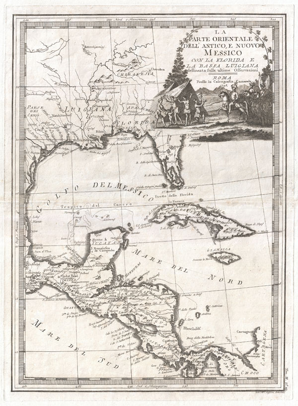
La parte orientale dell'antico e nuovo Messico con la Florida e la Bassa Luigiana dellineata sulle ultime osservazioni.
1798 (dated) 20.5 x 14.5 in (52.07 x 36.83 cm)
1798 (dated) 20.5 x 14.5 in (52.07 x 36.83 cm)
Description
This is a stunningly rendered 1798 map of Florida, the Gulf of Mexico, Louisiana, and Central America by the Italian cartographer Giovanni Maria Cassini. While visually alluring, this map is cartographically primitive. Florida is here represented as an archipelago. Cassini also fails to attach the Mississippi River to the Missouri. He does however make some effort at naming a number of American Indian tribes in the Mississippi Valley and Texas, including the Cherokee (Cherakesia), Chacumal, the Apalache, and the Cenis.
In the upper right quadrant there is an attractive decorative cartouche depicting a Spanish conquistador army entering an American Indian village. The naked villagers, including children, are clearly distraught and fearful, imploring either the conquistadores, god, or both for mercy. Interpreting this cartouche one can easily read Cassini's harsh criticism of Spain's brutal colonial policy in the Americas.
This map was published in Cassini's 1798 Nuovo Atlante Geografico Universale. This atlas was one of the last great decorative cartographic compilations of the 18th century and is exceptionally rare. Maps from this atlas with their modern cartouche work, distinctive engraving, rich dark impressions, and attractive border work are among the most desirable cartographic works of the period.
Cartographer
Giovanni Maria Cassini (1745 - 1824) was a Rome based Italian mathematician, globe maker, geographer, engraver, and cartographer active in the later part of the 18th and early 19th century. He was a disciple of Giovanni Battista Piranesi. He invented new form of projection used for an atlas of the kingdom of Naples issued by Giovanni Antonio Rizzi Zannoni. Cassini is best known as a globe maker and is considered the last of the great 18th century globe makers. His maps are distinctive for their fine engraving, dark strong impressions, and elaborate distinctive cartouche work. Unlike many map and atlas publishers of the period, Cassini did all of his own engraving work - this impregnating each map with his unmistakable style. Though he produced a significant corpus of well-regarded work, little is known of Cassini's personal life. G. M. Cassini is often mistakenly associated with the well-known French cartographic family of the same name, however, they are not related. More by this mapmaker...
Source
Cassini, G. M., Nuovo atlante geografico universale delineate suelle ultime osservazioni, Rome, 1798 edition.
Condition
Very good. Original centerfold. Original platemark visible. Blank on verso. Else very clean.
References
Library of Congress, Map Division, G3292.L3 1798 .C32. Lowery, The Lowery Collection. A Descriptive List of Maps of the Spanish Possessions, 719c. Phillips (Atlases) 719c.