
Cassini, Giovanni Maria

Giovanni Maria Cassini (1745 - 1824) was a Rome based Italian mathematician, globe maker, geographer, engraver, and cartographer active in the later part of the 18th and early 19th century. He was a disciple of Giovanni Battista Piranesi. He invented new form of projection used for an atlas of the kingdom of Naples issued by Giovanni Antonio Rizzi Zannoni. Cassini is best known as a globe maker and is considered the last of the great 18th century globe makers. His maps are distinctive for their fine engraving, dark strong impressions, and elaborate distinctive cartouche work. Unlike many map and atlas publishers of the period, Cassini did all of his own engraving work - this impregnating each map with his unmistakable style. Though he produced a significant corpus of well-regarded work, little is known of Cassini's personal life. G. M. Cassini is often mistakenly associated with the well-known French cartographic family of the same name, however, they are not related.
Detailed mapping of American Indian lands between the Mississippi River and the Appalachian Mountains following the American Revolutionary War.
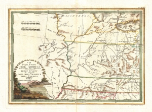
Gli Stati uniti dell' America delineati sulle ultime Osservazioni. Terzo foglio che comprende parte della Virginia.
$1,000.00
Acquire
- Digital Map Information
- Suitable for large format printing
- DPI: 300
- File Size: 9.22 MB
- File Type: ZIP / TIFF
- ICC color profile embedded
- Delivered instantly via download link
A very nice example of Cassini's stunning 1797 map of the eastern Mississippi watershed. The map covers from Lake Michigan to the modern day southern Tennessee border and from central Illinois to the Monongahela River. The focus of the map are the western claims, ... (more details)
Striking map of the Eastern Seaboard.
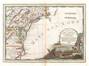
Gli Stati Uniti dell' America delineati sulle ultime Osservazioni, Quarto foglio che comprende parte della Nuova Inghilterra, la Nuova York, il Nuovo Yersey, la Pensilvania, il Delaware, il Maryland, e porzioni della Virginia, e della Carolina.
$950.00
Acquire
- Digital Map Information
- Suitable for large format printing
- DPI: 600
- File Size: 13.76 MB
- File Type: ZIP / TIFF
- ICC color profile embedded
- Delivered instantly via download link
An example of Giovanni Cassini's stunning 1797 map of the Eastern seaboard of the United States. Coverage embraces Massachusetts to Cape Lookout and inland as far as Lake Erie and western Maryland. Some of the banks and shoals of Cape Cod and Nantucket are noted. (more details)