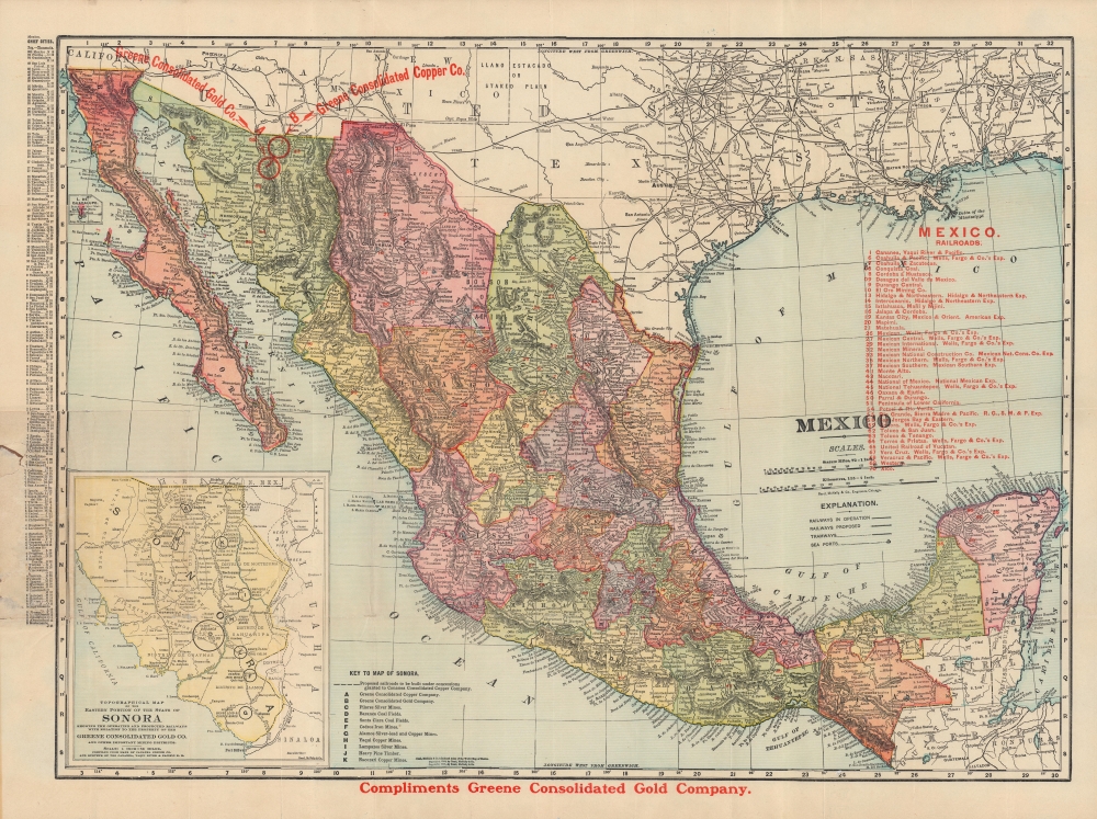
1904 Rand McNally Map of Mexico showing the Sonora Copper Mines
Mexico-randmcnally-1904$400.00

Title
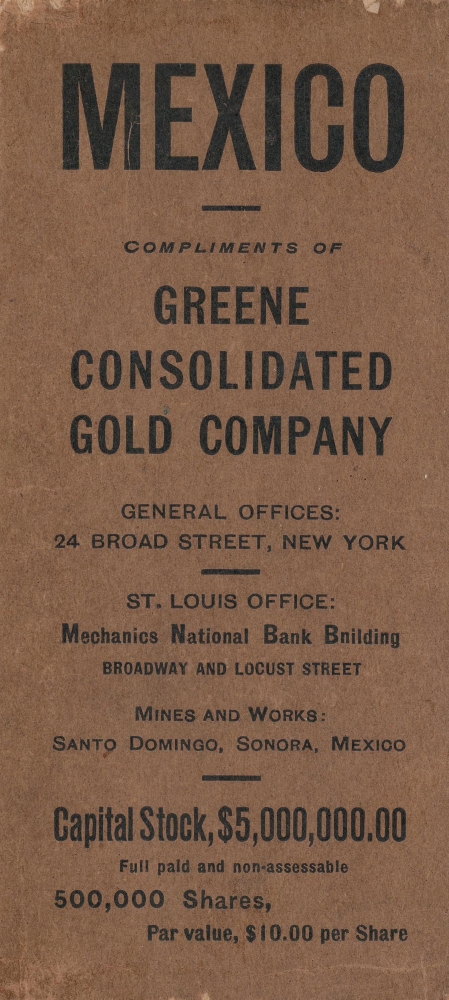
Mexico, compliments of Greene Consolidated Gold Company.
1904 (dated) 19 x 26 in (48.26 x 66.04 cm) 1 : 4561920
1904 (dated) 19 x 26 in (48.26 x 66.04 cm) 1 : 4561920
Description
A historically-significant 1904 Rand McNally map of Mexico issued by the Greene Consolidated Gold Company, one of several ventures owned by William Cornell Greene, an American businessman who operated a massive copper mine at Cananea, Sonora. The map was meant to entice American investors to fund Greene's sprawling empire, one destined to rapidly collapse only two years later.
To facilitate these efforts, the Mexican government systematically expelled rebellious indigenous populations to Henequen plantations in the distant Yucatán. Outside laborers, including from as far away as China, were brought in to work the mines, though rough conditions and low pay led to labor unrest. In 1906, a large-scale strike at Greene's mine was violently suppressed by a contingent Arizona Rangers and American volunteers. The incident scared off investors and ruined Greene, who was forced to sell his assets to business partners; afterwards, he retreated into obscurity at his home in Cananea. It was also a debacle for the Díaz government and in retrospect has been considered a precursor to the Mexican Revolution.
A Closer Look
The entirety of Mexico is depicted with states shaded for distinction. Red text overlays highlight railways and Greene's mines. An inset map of Sonora at bottom-left further emphasize Greene's mines and related ventures. Mountains, rivers, and other geographic features are clearly indicated, along with cities, railroads, and ports. An alphanumeric grid surrounds the map, corresponding to an index of cities and their populations at left.Mining, Resistance, and Revolution
At this time, Sonora had seen nearly two decades of resistance by Yaqui and other indigenous peoples against intrusion by central authorities and economic interests, especially agriculture and mining. The U.S.-aligned Porfirio Díaz government was eager to exploit the region's natural resources and readily worked with exploitive U.S. business interests. The Greene Consolidated Cooper and Gold Companies referenced here were owned by William Cornell Greene, a surveyor and prospector who in 1899 discovered vast copper reserves at Cananea, Sonora, near the Arizona border. Parlaying his gains in copper, Greene rapidly founded several other ventures, including the gold mining company as well as a railroad and numerous cattle ranches on both sides of the U.S.-Mexico border. These endeavors made him incredibly wealthy and allowed him to effectively run large portions of Sonora as a personal fiefdom.To facilitate these efforts, the Mexican government systematically expelled rebellious indigenous populations to Henequen plantations in the distant Yucatán. Outside laborers, including from as far away as China, were brought in to work the mines, though rough conditions and low pay led to labor unrest. In 1906, a large-scale strike at Greene's mine was violently suppressed by a contingent Arizona Rangers and American volunteers. The incident scared off investors and ruined Greene, who was forced to sell his assets to business partners; afterwards, he retreated into obscurity at his home in Cananea. It was also a debacle for the Díaz government and in retrospect has been considered a precursor to the Mexican Revolution.
Publication History and Census
This map was drawn and published by Rand McNally and issued by the Greene Consolidated Gold Company in 1904. It is listed among the holdings of roughly twenty institutions in OCLC and is scarce to the market.Cartographer
Rand, McNally and Co. (fl. 1856 - present) is an American publisher of maps, atlases and globes. The company was founded in 1856 when William H. Rand, a native of Quincy, Massachusetts, opened a print shop in Chicago. Rand hired the recent Irish immigrant Andrew McNally to assist in the shop giving him a wage of 9 USD per week. The duo landed several important contracts, including the Tribune's (later renamed the Chicago Tribune) printing operation. In 1872, Rand McNally produced its first map, a railroad guide, using a new cost effective printing technique known as wax process engraving. As Chicago developed as a railway hub, the Rand firm, now incorporated as Rand McNally, began producing a wide array of railroad maps and guides. Over time, the firm expanded into atlases, globes, educational material, and general literature. By embracing the wax engraving process, Rand McNally was able to dominate the map and atlas market, pushing more traditional American lithographic publishers like Colton, Johnson, and Mitchell out of business. Eventually Rand McNally opened an annex office in New York City headed by Caleb S. Hammond, whose name is today synonymous with maps and atlases, and who later started his own map company, C. S. Hammond & Co. Both firms remain in business. More by this mapmaker...
Condition
Fair. Original binder attached. Damage to lower third of index. Professional repairs along fold separation and fold intersections on verso. Area of infill at border between Chihuahua and Texas.
References
OCLC 857243099.