This item has been sold, but you can get on the Waitlist to be notified if another example becomes available, or purchase a digital scan.
1851 Tallis Map of Mexico, Texas (Republic) and California (Gold Region)
MexicoCaliforniaTexas-tallis-1851$275.00

Title
Mexico, California and Texas.
1851 (undated) 10 x 13.5 in (25.4 x 34.29 cm) 1 : 9216000
1851 (undated) 10 x 13.5 in (25.4 x 34.29 cm) 1 : 9216000
Description
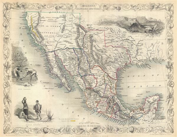
This is John Tallis's and J.H. Rapkin's highly desirable 1851 Map of Mexico, Texas and Upper California shortly after the Mexican American War and in the early days of the California Gold Rush. Texas is depicted at its fullest extent including both Santa Fe and the Green Mountains. Upper California offers numerous interesting elements, most specifically a colored and labeled Gold Region extending along the Sacramento River as far south as an oversized Lake Tule and Santa Cruz. The 'Great Caravan Route' followed by covered wagons during the Westward Expansion is also noted as it snakes its way across northern Texans and southern California to Los Angeles. The various Intendencia of Mexico are highlighted in outline color. The map also offers several beautiful vignettes by H. Warren and J. Rogers. These attempt to illustrate Mexican life, including Mayan ruins at Uxmal (Yucatan), gold panning in California, and 'Mexican Peasantry.'
This map appeared simultaneously in several publications including Tallis' Illustrated Atlas and Hinton's History and Topography of the United States of America. Cartographically there are no significant differences between the versions, however, the imprint on the Illustrated Atlas map reads 'John Tallis and Company, London and New York; while the History and Topography example reads 'John Tallis, London, Edinburgh & Dublin.' Those examples published with the History and Topography, as above, also have a centerfold sometimes not present in the Illustrated Atlas edition. Tallis is considered one of the last great decorative map and atlas publishers of the 19th century.
This map appeared simultaneously in several publications including Tallis' Illustrated Atlas and Hinton's History and Topography of the United States of America. Cartographically there are no significant differences between the versions, however, the imprint on the Illustrated Atlas map reads 'John Tallis and Company, London and New York; while the History and Topography example reads 'John Tallis, London, Edinburgh & Dublin.' Those examples published with the History and Topography, as above, also have a centerfold sometimes not present in the Illustrated Atlas edition. Tallis is considered one of the last great decorative map and atlas publishers of the 19th century.
Cartographer
John Tallis and Company (1838 - 1851) published views, maps, and atlases in London from roughly 1838 to 1851. Their principal works, expanding upon the earlier maps of John Cary and Aaron Arrowsmith, include an 1838 collection of London Street Views and the 1849 Illustrated Atlas of the World. The firm’s primary engraver was John Rapkin, whose name and decorative vignettes appear on most Tallis maps. Due to the embellishments typical of Rapkin's work, many regard Tallis maps as the last bastion of English decorative cartography in the 19th century. Although most Tallis maps were originally issued uncolored, it was not uncommon for 19th century libraries to commission colorists to "complete" the atlas. The London Printing and Publishing Company of London and New York bought the rights for many Tallis maps in 1850 and continued issuing his Illustrated Atlas of the World until the mid-1850s. Specific Tallis maps later appeared in innumerable mid to late-19th century publications as illustrations and appendices. More by this mapmaker...
Source
Hinton, J. H., History and Topography of the United States of America, 1852.
Condition
Very good condition. Minor wear on original centerfold. Blank on verso.
References
Phillips, 804-71. Rumsey, 0466.072.