This item has been sold, but you can get on the Waitlist to be notified if another example becomes available, or purchase a digital scan.
1836 Perthes Map of Mexico with Republic of Texas
MexicoCentroAmerica-perthes-1836$475.00

Title
Mexico und Centro-America.
1836 (dated) 13.5 x 16.5 in (34.29 x 41.91 cm) 1 : 13500000
1836 (dated) 13.5 x 16.5 in (34.29 x 41.91 cm) 1 : 13500000
Description
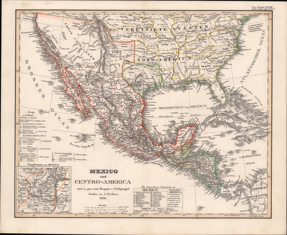
This is Justus Perthes's 1836 map of Mexico and Central America, one of the first maps to depict Texas as a Republic. Although the German Empire never formally recognized the Republic of Texas, by 1836 there was already significant German immigration to Texas.
A Closer Look
The map is appropriately centered on the Republic of Texas, formed just months before this map was engraved. As this map predates the Mexican-American War (1846 - 1848), the borders of Mexico extend north as far as Oregon and Great Salt Lake. San Francisco is identified by the Mexican fort 'El Presidio'. Further coverage extends through Central America to Panama, and includes the United States as far north as the Great Lakes and east to the Atlantic seaboard.Republic of Texas
The Republic of Texas was a short-lived nation established in March of 1836 when it ceded from Mexico. Following the independence of Mexico from Spain in 1821, the American Stephen Fuller Austin led a group of 300 Empresarios to settle Texas, near Austin, where they received a grant from the Mexican government. As more Americans moved to Texas, resentment and strife began to build between the American settlers and Mexican authorities. This and other factors ultimately led to the Texan Revolution in 1835 and the declaration of Texan independence in 1836. Texas remained an independent republic until it joined the United States 10 years later in 1846.Germans in Texas
German immigration to Texas began in the 1830s, before the formal proclamation of the Republic of Texas. Most settled in the so-called German Belt - a stretch of land in south-central Texas extending from Galveston to Hondo. Most early German interest in Texas can be attributed to Friedrich Diercks, known in Texas under his alias Johann Friedrich Ernst. Ernst settled in Texas in 1831. His letters to friends in Germany extolled Texas as a Sicilian-like paradise with endless free land, game, and opportunity. They attained wide readership in northwestern Germany, many being published in newspapers and guidebooks. His enthusiasm inspired a steady stream of German immigration to Texas through the 1830s and into the early 1840s. German noblemen, concerned with overpopulation in rural Germany, created the Adelsverein, also known as the Verein zum Schutze Deutscher Einwanderer or the 'German Emigration Company' to promote relocation to Texas. The company transported more than 7,000 immigrants between 1844 and 1847. By the end of the Mexican-American War there was a large and prosperous German Texan community, but the largest influx of German immigrants followed the failed Spring Revolutions of 1848, when thousands of '48ers' fled en masse to the United States, many settling with friends and family in Texas.Texas Borders
The borders of the Republic of Texas were in dispute from the earliest days of the Texan Revolution. The Republic-claimed borders followed the Treaties of Velasco between the newly created Texas Republic and Mexican leader, Antonio López de Santa Anna. The treaties established an eastern boundary following the 1819 Adams-Onís Treaty between the United States and Spain, which established the Sabine River as the eastern boundary of Spanish Texas and western boundary of the Missouri Territory. The Republic's southern and western boundary with Mexico was more nuanced. Texas claimed the Rio Grande del Norte as its western and southernmost border, while Mexico argued for a boundary much further east at the Nueces River (as here). When Texas was annexed into the United States, the agreement followed the Republic-claimed boundary, thus absorbing Mexican-claimed territory as far west as Santa Fe. This escalated already existing tensions between the United States, the former Republic of Texas, and Mexico, ultimately triggering for the Mexican-American War (1846 -1848).Publication History and Census
This map was first issued in 1828 for the first or 'Zero-B' Justus Perthes edition of Stieler's Hand-Atlas. The present example, dating to 1836, is the first Perthes map to illustrate the Republic of Texas - a polity that was not officially recognized in Germany. While most Perthes atlas maps can hardly be considered rare, we have found very few examples of this ephemeral edition. We note an example at Baylor University and three in German institutional collections. Scarce.Source
Stieler's Hand-Atlas, (Gotha: Perthes) 1836.
Condition
Very good.
References
OCLC 165474302.