1886 Debray Chromolithograph Map of Mexico City
MexicoCity-debray-1886$4,000.00


Title
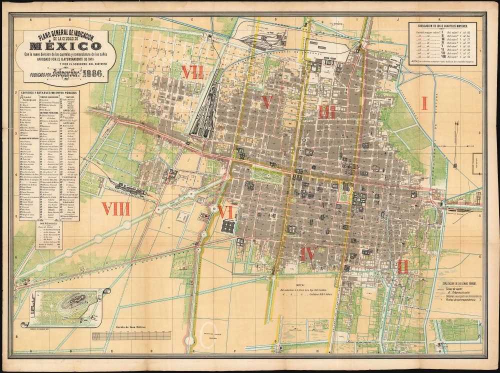
Plano general de indicacion de la Ciudad de Mexico : con la nueva division de los cuarteles y nomenclatura de los calles aprobado por el H. Ayuntamiento de 1885 y por el gobierno del distrito.Publicado por Debray Sucs. 1886.
1886 (dated) 24.5 x 34 in (62.23 x 86.36 cm) 1 : 7800
1886 (dated) 24.5 x 34 in (62.23 x 86.36 cm) 1 : 7800
Description
This is a rare, colorful plan of Mexico City, published in 1886 by the lithographers DeBray Sucesores based on official data from the Mexico City government. It reflects the efforts the early ambitions of the Porfiriato, wherein Porfiro Díaz (1830 - 1915), influenced by Paris' transformation under Haussmann, sought to modernize and embellish Mexico City to equal the great capitals of Europe.
The (unjustifiably obscure) Mexican lithographer Debray appears to have had a long relationship with the city government, dating to the life of the firm's patriarch, Victor Debray. He printed a plan of the city in 1875, updated in 1880, which formed the basis for the present work. This map introduces new administrative divisions of the city and reflects significant development not apparent in the earlier map. It not only indicates the spread of general construction, but also the alterations of monumental aspects of the city, and the drastic expansion of the city's railroads. New public construction is marked in bold black outline and keyed by number to the pamphlet. Later official works, both published by Debray and by Montauriol, use the present work as a foundation.
Overview
The plan is centered on the Alameda Central, and uses color to differentiate built-up areas, green spaces, and areas available for development. The result is a beautiful, balanced work far from the Spartan aesthetic one might expect from an official document. This brightly colored and clearly lettered plan highlights the city's boulevards and parks. An inset map details the Bosque de Chapultepec, highlighting the military school on its grounds.The (unjustifiably obscure) Mexican lithographer Debray appears to have had a long relationship with the city government, dating to the life of the firm's patriarch, Victor Debray. He printed a plan of the city in 1875, updated in 1880, which formed the basis for the present work. This map introduces new administrative divisions of the city and reflects significant development not apparent in the earlier map. It not only indicates the spread of general construction, but also the alterations of monumental aspects of the city, and the drastic expansion of the city's railroads. New public construction is marked in bold black outline and keyed by number to the pamphlet. Later official works, both published by Debray and by Montauriol, use the present work as a foundation.
Modernizing Meixco City
In 1886, Mexico City stood at the crossroads of tradition and modernization, reflecting the ambitions of President Porfirio Díaz's regime during the early years of the Porfiriato. The capital was undergoing significant urban transformation influenced by French models, with wide boulevards, ironwork architecture, gas lighting, and the beginnings of streetcar lines reshaping its colonial layout. Under Diaz, elite cultural life flourished, with theaters, newspapers, and educational institutions expanding, even as political dissent was suppressed. Mexico City in 1886 was thus a symbol of national aspiration - eager to present itself as a modern capital, while still grappling with deep-rooted social and economic divisions.Publication History and Census
This plan was printed to accompany the pamphlet Nueva Subdivision de la Ciudad de Mexico, printed on behalf of the city by Francisco Diaz de Leon in 1886. We see examples held at Princeton University and in the David Rumsey Collection. A significantly smaller version of the plan, published in 1889, is cataloged by the University of Pittsburgh and the University of Texas at Austin. We see nine examples of Nueva Subdivision de la Ciudad de Mexico in OCLC, none of which are noted to contain a map.Source
Mexico City Hall, Nueva Subdivision de la Ciudad de Mexico en Cuarteles y Manzanas y Correspondencia con la Antigua, (Mexico City: Diaz de Leon, Francisco) 1886.
Condition
Very good. One mended split at left, only impacting table. Else excellent with virtually no wear at folds. Text separate, but present in good condition.
References
OCLC 761890634. Rumsey 11439.007.