1828 / 1846 Norie Blueback Chart of the West Coast of Mexico and Central America
MexicoCoast-norie-1846$1,600.00


Title
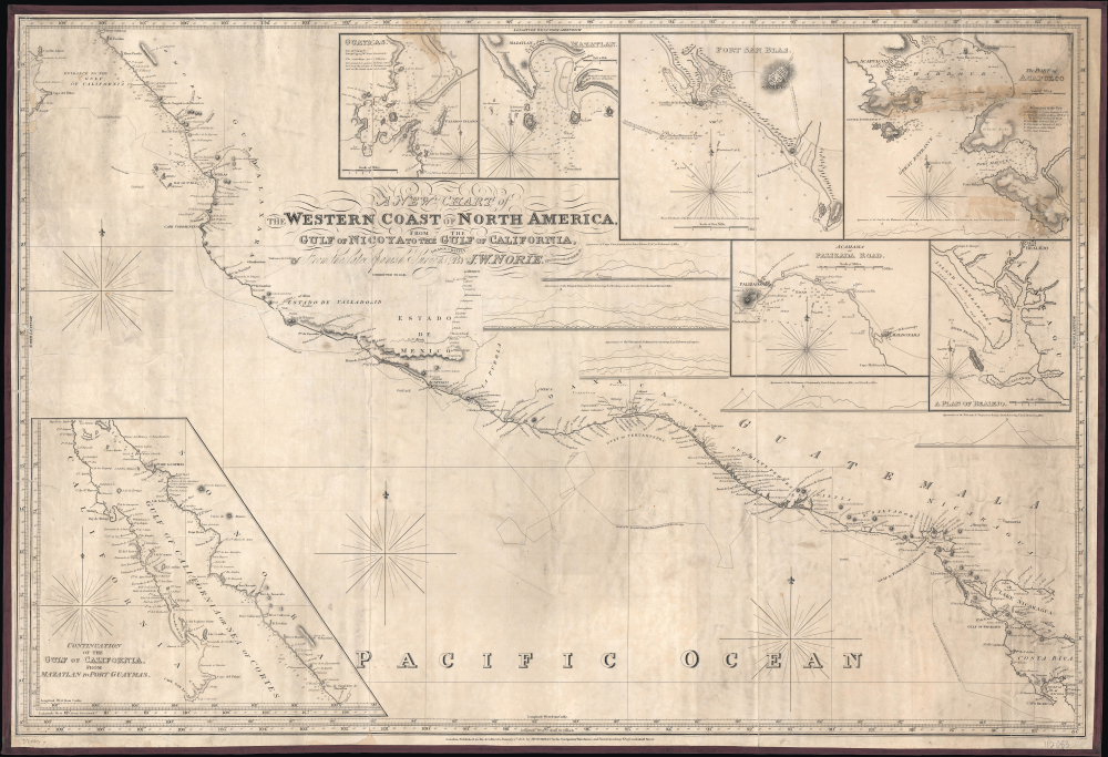
A New Chart of the Western Coast of North America from the Gulf of Nicoya to the Gulf of California, Drawn Chiefly From the late Spanish Surveys.
1846 (dated) 25.75 x 38 in (65.405 x 96.52 cm) 1 : 2750000
1846 (dated) 25.75 x 38 in (65.405 x 96.52 cm) 1 : 2750000
Description
This is J. W. Norie's 1828 large-format nautical chart of the west coast of Mexico and Central America, corrected to 1846. The map was updated and republished to capitalize on increased activity along this strategic coastline during the Mexican-American War (1846 - 1848). Being outside of U.S. waters, naval commanders resorted to existing and updated commercial charts, like this one, to control the coast.
Seven inset maps surround the main map, displaying soundings, hazards, anchorages, shoals, and other detailed navigational information. The inset maps cover Guaymas, Mazatlán, Port San Blas, the Port of Acapulco, Cabo Maldonado, and (El) Realejo. At the bottom-left is a large inset of almost the entire Gulf of California. Five profiles of mountains and volcanoes along the coast appear below the insets at the top-right.
The tradition took off in the early 19th century, when British publishers like John Hamilton Moore, Robert Blachford, James Imray, William Heather, John William Norie, Charles Wilson, David Steel, R. H. Laurie, and John Hobbs, among others, rose to dominate the chart trade. Bluebacks became so popular that the convention was embraced by chartmakers outside of England, including Americans Edmund March Blunt and George Eldridge, as well as Scandinavian, French, German, Russian, and Spanish chartmakers. Blueback charts remained popular until the late 19th century, when government-subsidized organizations, such as the British Admiralty Hydrographic Office and the United States Coast Survey, began issuing their own superior charts on high-quality paper that did not require reinforcement.
A Closer Look
The map covers from the Gulf of California to Cabo Blanco in Costa Rica. Soundings are provided from Cabo Corrientes north to the Gulf of California and periodically at other points. Coastal settlements, landmarks (especially mountains), river estuaries, ports, points, banks, islands, and anchorages are marked throughout. The voyages of late 18th century Spanish and British explorers are tracked, as is the road from Acapulco to Mexico City, still an important route even well after the heyday of the Spanish Galleon Trade (and by this time even after Mexican independence).Seven inset maps surround the main map, displaying soundings, hazards, anchorages, shoals, and other detailed navigational information. The inset maps cover Guaymas, Mazatlán, Port San Blas, the Port of Acapulco, Cabo Maldonado, and (El) Realejo. At the bottom-left is a large inset of almost the entire Gulf of California. Five profiles of mountains and volcanoes along the coast appear below the insets at the top-right.
Historical Context: Mexican-American War
In 1846, western Mexico was indirectly impacted by the outbreak of the Mexican-American War, which began in May of that year following disputes over the annexation of Texas. Although the principal military confrontations occurred in northern and central Mexico, the western states - such as Jalisco, Michoacán, Colima, Sinaloa, and Sonora - played important strategic and logistical roles. The U.S. Navy, under Commodore John D. Sloat and later Robert F. Stockton, began operations along Mexico's Pacific coastline. In July 1846, U.S. forces occupied Monterey, California, then part of Mexican territory. This raised fears of further incursions into Mexico's Pacific ports, such as Mazatlán, San Blas, and Manzanillo. Being outside of U.S. waters, thus not a subject of U.S. coastal mapping programs, naval commanders were forced to rely on commercial charts, as here, for navigation.Blueback Charts
Blueback nautical charts began appearing in London in the late 18th century. Bluebacks, as they came to be called, were privately published large-format nautical charts known for their distinctive blue paper backing. The backing, a commonly available blue manila paper traditionally used by publishers to wrap unbound pamphlets, was adopted as a practical way to reinforce the low-quality paper used by private chart publishers in an effort to cut costs. That being said, not all blueback charts are literally backed with blue paper. The earliest known blueback charts include a 1760 chart issued by Mount and Page and a 1787 chart issued by Robert Sayer.The tradition took off in the early 19th century, when British publishers like John Hamilton Moore, Robert Blachford, James Imray, William Heather, John William Norie, Charles Wilson, David Steel, R. H. Laurie, and John Hobbs, among others, rose to dominate the chart trade. Bluebacks became so popular that the convention was embraced by chartmakers outside of England, including Americans Edmund March Blunt and George Eldridge, as well as Scandinavian, French, German, Russian, and Spanish chartmakers. Blueback charts remained popular until the late 19th century, when government-subsidized organizations, such as the British Admiralty Hydrographic Office and the United States Coast Survey, began issuing their own superior charts on high-quality paper that did not require reinforcement.
Publication History and Census
This chart was prepared by John William Norie in 1828 and is here 'corrected to 1846.' In any state, the chart is quite rare and is only noted in institutional collections at the National Maritime Museum in Greenwich and the Biblioteca Nacional do Brasil.Cartographer
John William Norie (June 3, 1772 - December 24, 1843) was a British teacher of navigation, hydrographer, chart maker, and publisher of maritime manuals active in London, England in the late 18th and early 19th centuries. Norie was born in Wapping, London, an area long associated with the maritime sciences. Norie's career as a chart maker commenced under the tutelage of William Heather, a prominent purveyor and publisher of nautical charts, pilot books, and navigational tools who took over the firm of Mount and Page in 1765. Heather and Norie were likely acquainted through John Hamilton Moore, another important chart maker with whom both seem to have been associated early in their careers. Heather hired Norie to teach basic navigation at his shop at 157 Leadenhall Street. Under Heather Norie also distinguished himself as a draftsman, completing many of the early charts associated with the Heather firm. When Heather died in 1812 John Norie partnered with George Wilson, a moneyed 'man about town' with little experience in the maritime trades, to acquire the map and chart business at 9500 British Pounds. It proved a good deal for Norie, who retained all copyright privileges and drew 1/4 quarter share of business profits, as well an impressive quarterly salary and, for doing all of the work, 1/3rd of Wilson's share. The firm, referred to as the 'Naval Warehouse' quickly acquired a reputation for quality navigational materials and became a favorite of merchant seamen. It was even referenced in Charles Dickens' classic novel Dombey and Son. In 1819, Norie and Wilson acquired the failing chart business of David Steel, which significantly increased the size, though not quality, of their chart catalogue. With the rise of the British Admiralty and its own maritime chart productions, the business of "Chart Purveyor" in London dramatically changed. Admiralty charts and pilot books, designed for military use, were offered through established intermediaries, like Norie, at bargain prices. Most chart makers of the period found it profitable to use the highly technical Admiralty charts to update their own more decorative vernacular charts. For a brief time this practice proved exceptionally profitable but eventually began to draw criticism. Nonetheless, Norie retired to Edinburgh in 1840 and died a wealthy man in 1843. In 1840 the business passed to a nephew of George Wilson, Charles Wilson, who renamed the firm "Norie & Wilson". William Heather Norie, J. W. Norie's own son, produced few charts, instead pursuing a career in the legal field. Norie & Wilson merged with James Imray's prosperous chart business in 1899, becoming Imray, Laurie, Norie & Wilson, a profitable concern that remains active in the maritime charting industry. More by this mapmaker...
Condition
Fair. Full professional restoration. Mounted on blue linen. Closed tear from top to bottom extending through Guaymas inset and title. Area in top right corner reinstated. Soiling. Areas of reinstatement along edges.
References
Royal Museums Greenwich (National Maritime Museum) Object ID: G278:8/1(1). Biblioteca Nacional do Brasil: Cartografia - ARC.024,06,016.