This item has been sold, but you can get on the Waitlist to be notified if another example becomes available, or purchase a digital scan.
1822 Direccion de Hidrografia Nautical Chart or Map of Mexico and Guatemala
MexicoGuatemala-hidrografia-1822$475.00

Title
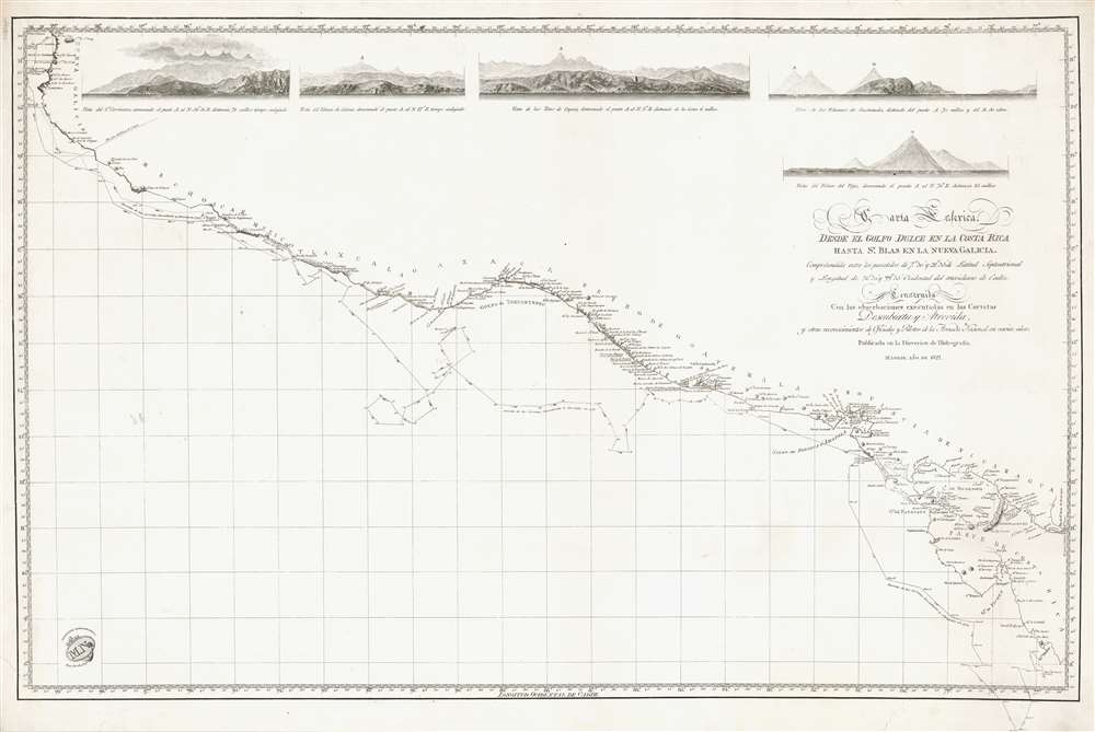
Carta Esferica desde el Golfo Dulce en la Costa Rica hasa Sn. Blas en la Nueva Galicia.
1822 (dated) 24.5 x 36.5 in (62.23 x 92.71 cm) 1 : 2800000
1822 (dated) 24.5 x 36.5 in (62.23 x 92.71 cm) 1 : 2800000
Description
Representing the most advanced data available to the Spanish Admiralty at the time, this 1822 Direccion Hidrografía nautical chart or maritime map details the Pacific coast of Central America from southern Mexico and Guatemala to Costa Rica. The chart traces the movements of the 1789 - 1794 Spanish government sponsored Malaspina Expedition, a scientific expedition akin to those of Captain Cook, and labels the expedition's two ships the Descubierta and the Altrevida. Guatemalan volcanoes, Lake Nicaragua, and Acapulco are among the many coastal features. Five coastal views are included along the top border and illustrate the Volcán de Colima in Mexico, the Volcán de Vieja in Costa Rica, and the volcanoes of Guatemala.
The Malaspina Expedition
The Malaspina Expedition was a 5-year naval odyssey of exploration led by Alessandro Malaspina and José de Bustamante y Guerra. With a crew that included cartographers, naturalists, scientists, and skilled draftsmen, the expedition left Cádiz on July 20, 1789. Inspired by the achievements of Cook and Laperousse, the expedition's goal was to compile the first concrete scientific description of Spain's American colonies. The convoy crossed the Atlantic Ocean, stopped at the Rio de la Plata, and then sailed around Cape Horn into the Pacific Ocean. They spent the next three and a half years in the Pacific, crossed it twice, and visited the newly established British colony of Port Jackson (Sydney) in New South Wales, Australia. Along the way, cartographers fixed the measurements of America's west coast with a level of precision never before achieved. Considered a major success, the expedition collected ethnographic treasures, measured the heights of mountains, explored glaciers, mapped shorelines, collected natural specimens, and were the first major long-distance sea voyage that didn't experience an outbreak of scurvy.Publication History and Census
This map was created and published by the Direccion Hidrografía in 1822. The OCLC catalogues only one example, which is part of the collection at the Biblioteca Nacional in Madrid. We have also found references to a possible example at the Madrid Naval Museum Archive.Cartographer
The Direccion Hidrografía (1787 - 1927), also known as the Deposito Hydrografico and the Direction de Hidrografía, was the Spanish equivalent of the British Admiralty or the U.S. Coast Survey. This organization, founded in 1787, was commissioned to collect and produce accurate nautical charts of all waters frequented by Spanish vessels. In essence, it replaced the Casa de la Contratación de las Indias (House of Trade of the Indies), which closed its doors in 1790. Like most such organizations, the Direccion Hidrografía marked a new age in cartography. Rather than simply collect charts created by navigators, explorers, and merchants, the Direccion Hidrografía worked closely with naval and military personnel to mount cartographic and hydrographic expeditions in pursuit of the most accurate hydrographical, astronomical, and geodetic measurements. The Direccion Hidrografía created a massive library of nautical charts that, though not nearly as common as similar nautical charts by the U.S. Coast Survey and British Admiralty, are highly desirable for the beauty of their manufacture as well as their accuracy and detail. The office was originally located on Calle Ballesta, but relocated to 36 Alcala, both in Madrid. After 1908 the Dirección was subsumed into other governmental agencies. In 1927 the Direccion was absorbed into the Institute and Observatory of San Fernando, located in Cadiz. The library of original maps, charts, and journals was transferred to the Naval Museum of Madrid - where it resides to this day. More by this mapmaker...
Condition
Very good. Even overall toning. Blank on verso.
References
OCLC 431562395.