This item has been sold, but you can get on the Waitlist to be notified if another example becomes available, or purchase a digital scan.
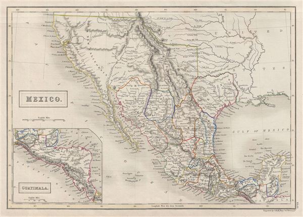
1840 Black Map of Mexico and Texas as a Republic
MexicoTexas-black-1840$175.00

Title
Mexico.
1840 (undated) 11.5 x 16 in (29.21 x 40.64 cm)
1840 (undated) 11.5 x 16 in (29.21 x 40.64 cm)
Description
A fine example of Adam and Charles Black's 1840 map of Mexico and an Independent Texas. The map covers all of modern day Mexico as well as then pre-1846 Mexican territory in Upper California and a rebellious Texas. An inset map on the lower left corner details Guatemala and Belize. Though this map was issued after the 1836 Texas War of Independence, it is shown as part of Mexico – suggesting that Black and england in general thought poorly of rebellious colonies. In 1845, following nearly a decade of semi-independence, Texas joined the United States, becoming its 28th state. This map was engraved by S. Hall for issue as plate 45 in the 1840 edition of Black's General Atlas.
Cartographer
Charles and Adam Black (fl. 1807 - present) were map and book publishers based in Edinburgh. Charles and his uncle, Adam, both of Edinburgh, Scotland, founded their publishing firm in 1807. They published a series of maps and atlases throughout the 19th century. In addition to an array of atlases, the Black firm is known for their editions of the Encyclopedia Britannica (1817 - 1826) and the first publishing of Sir Walter Scott's novels in 1854. In 1889 the A. & C. Black publishing house moved to London where it remains in operation to this day. More by this mapmaker...
Source
Hall, Sydney, Black's General Atlas: A series of Fifty-Four Maps from the Latest and Most Authentic Sources, Engraved on Steel, In the First Style of the Art, (Edinburgh: Adam and Charles Black) 1840.
Black's General Atlas was a popular Scottish atlas of the world issued by the Edinburgh firm of Adam and Charles Black. This atlas was first issued in 1840 with subsequent editions being printed well into the 1890s. While most editions were printed in Edinburgh, an American edition was issued in 1857. Most early editions of his atlas were engraved by S. Hall. Typically this refers to Sidney Hall, who died in 1831, but in this case, since the engraving was initiated well after his death, it was most likely his widow, Selina Hall, who did the engraving. Later editions feature additional maps updated and engraved by William Hughes. Early editions featured outline color only, but later editions embraced a full color approach with pale green, yellow, and blue pastels. All editions are known for their meticulous presentation of the most up-to-date cartographic information. Moreover, this exceptionally long publication run provides a fine cartographic record of the middle to late 19th century - particularly as regards the complex cartographic evolution of the Americas through this period.
Condition
Very good. Blacnk on verso. Original platemark visible.
References
Rumsey 2305.059 (1854 edition). Philips (atlases) 4334.