This item has been sold, but you can get on the Waitlist to be notified if another example becomes available, or purchase a digital scan.
1851 Tallis Map of Mexico, Texas, and California
MexicoTexas2-tallis-1851$262.50

Title
Mexico.
1851 (undated) 10 x 13.5 in (25.4 x 34.29 cm)
1851 (undated) 10 x 13.5 in (25.4 x 34.29 cm)
Description
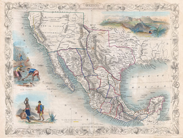
An exceptional example of John Tallis and John Rapkin's highly desirable 1851 Map of Mexico, Texas, and Upper California. Herein Texas is depicted at its fullest extent including both Santa Fe and a northern extension encompassing the Green Mountains. Drawn at the height of the California Gold Rush, this map responds to the international interest in the region by highlighting the gold fields in the Sacramento and San Joaquin valley. The 'Great Caravan Route' used by covered wagons during the westward expansion is also noted. Tallis and Rapkin erroneously combine Great Salt Lake and Utah Lake - a curious and uncommon mistake that is most likely merely and engravers blunder. Upper California is surrounded by a green border, likely meant to communicate its transfer to the United States following the Treaty of Guadeloupe-Hidalgo, though such is not specifically noted anywhere on the map. Similarly, Texas, though clearly separated from Mexico is not clearly part of the United States. These omissions suggest that Tallis was reluctant to significantly update his map plates to reflect the changing political situation in the American Southwest. Offers several beautiful vignettes drawn by H. Warren and J. Rogers depicting the Ruins at Uxmal, Yucatan, panning gold in California, and Mexican Peasantry. Undated, but the defined gold regions allows us to identify this as the 1851 issued of Tallis's valuable map. Drawn by John Rapkin for issue in the 1851 edition of John Tallis' Illustrated Altas.
Cartographer
John Tallis and Company (1838 - 1851) published views, maps, and atlases in London from roughly 1838 to 1851. Their principal works, expanding upon the earlier maps of John Cary and Aaron Arrowsmith, include an 1838 collection of London Street Views and the 1849 Illustrated Atlas of the World. The firm’s primary engraver was John Rapkin, whose name and decorative vignettes appear on most Tallis maps. Due to the embellishments typical of Rapkin's work, many regard Tallis maps as the last bastion of English decorative cartography in the 19th century. Although most Tallis maps were originally issued uncolored, it was not uncommon for 19th century libraries to commission colorists to "complete" the atlas. The London Printing and Publishing Company of London and New York bought the rights for many Tallis maps in 1850 and continued issuing his Illustrated Atlas of the World until the mid-1850s. Specific Tallis maps later appeared in innumerable mid to late-19th century publications as illustrations and appendices. More by this mapmaker...
Source
Tallis, J., The Illustrated Atlas, And Modern History Of The World Geographical, Political, Commercial & Statistical, 1851.
Condition
Very good. Orignal centerfold. Light toning.
References
Phillips (Alases) 804-71. Rumsey, 0466.072. Wheat, C., The Mapping of the Transmississippi West, 1540-1861, 737.