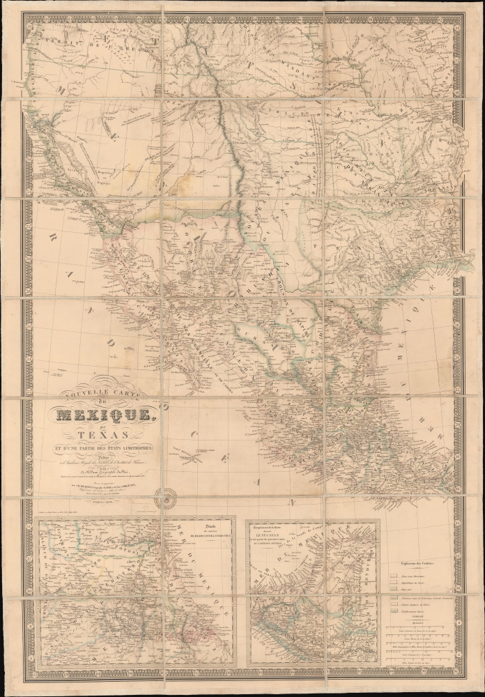
1845 Brue Map of Mexico and the Republic of Texas
MexiqueTexas-brue-1845$7,000.00


Title
Nouvelle Carte du Mexique, du Texas et d'une partie des états limitrophes...
1845 (dated) 27 x 38.75 in (68.58 x 98.425 cm) 1 : 500000
1845 (dated) 27 x 38.75 in (68.58 x 98.425 cm) 1 : 500000
Description
This is the 1845 edition of Adrien-Hubert Brué's seminal map of Mexico and the Republic of Texas - issued at the peak of the Mexican-American War (1846 - 1848). Wheat rightly hails this as a 'most important map.' Its significance is as expansive as its converge, ranging from up-to-date cartography regarding the Republic of Texas (and the French recognition thereof), to some of the first printed mappings of the cartography of Jedediah Smith, to one of the earliest uses of the term 'Arizona' on a printed map.
Insets detail the Yucatan, which then, like Texas, had declared itslef independent and was involved in a general revolt against central Mexican authority (see our block text below). A second inset details east-central Mexico centered on Mexico City. This inset map features extensive manuscript annotation tracing an overland voyage with daily stops from Veracruz to Puebla.
A Closer Look
Coverage embraces the southwestern parts of North America, from the Umpqua River and Oregon Territory south to include the Republic of Texas and Mexico as far as the Isthmus of Tehuantepec. East-west coverage extends from the Pacific Coast to the Mississippi River. It contains the nascent Republic of Texas and what soon would become the U.S. Southwest: California, New Mexico, Arizona, Utah, Nevada, Colorado, Nebraska, etc.Insets detail the Yucatan, which then, like Texas, had declared itslef independent and was involved in a general revolt against central Mexican authority (see our block text below). A second inset details east-central Mexico centered on Mexico City. This inset map features extensive manuscript annotation tracing an overland voyage with daily stops from Veracruz to Puebla.
Republic of Texas
The Republic of Texas, as illustrated here, was a short-lived nation established in March 1836 when it seceded from Mexico. Following the independence of Mexico from Spain, the American Stephen Fuller Austin led a group of 300 Empresarios to settle Texas, near Austin, where they received a grant from the Mexican government. As more Americans and Europeans moved to Texas, resentment and strife began to build between the American settlers and Mexican authorities. This and other factors ultimately led to the Texan Revolution in 1835 and the declaration of Texan independence in 1836. Texas remained an independent republic until it joined the United States ten years later in 1846.Texas Borders
The borders of the Republic of Texas were in dispute from the earliest days of the Texan Revolution. The Republic-claimed borders followed the Treaties of Velasco between the newly created Texas Republic and Mexican leader, Antonio López de Santa Anna. The treaties established an eastern boundary following the 1819 Adams-Onís Treaty between the United States and Spain, establishing the Sabine River as the eastern boundary of Spanish Texas and the western boundary of the Missouri Territory. The Republic's southern and western boundary with Mexico was more nuanced. Texas claimed the Rio Grande del Norte as its western and southernmost border, while Mexico argued for a boundary much further east at the Nueces River. When Texas was annexed into the United States, the agreement followed the Republic-claimed boundary, thus absorbing Mexican-claimed territory as far west as Santa Fe. This escalated already existing tensions between the United States, the former Republic of Texas, and Mexico, ultimately triggering the Mexican-American War (1846 -1848).France Recognizes the Republic of Texas
When Texas seceded from Mexico on April 21, 1836, it immediately sought legitimacy through diplomatic appeals to major world powers - most of which were in Europe. Most European powers were reluctant to recognize the self-proclaimed Republic until it became clear that it could survive and what diplomatic ramifications, if any, formal recognition might yield. Nonetheless, France under King Louis Philippe recognized Texas on September 25, 1839. This act may have been partially trade-inspired and partially motivated by French antipathy towards Mexico following the First French Intervention or Pastry War (1838 - 1839). Recognizing Texas diplomatically allowed France to open official trade channels, particularly for cotton, a vital commodity in Europe and an increasing cause of tension between France and Britain. Moreover, the recognition of Texas accelerated the destabilization of Mexico, increasing the probability that any colonial aspirations the French may have had in seizing California would be successful.Early Texas Railroads
The map reveals the earliest stages of the Texas railroad construction. Here, two lines are illustrated: a track between Washington and Houston, then connecting to the Rio Brazos, and a secondary track connecting Columbia on the Rio Brazos to Galveston Bay.Jedediah Smith Geography
As pointed out by Wheat, this series of maps is among the first printed maps to illustrate Jedediah Smith's seminal geography. The Brue firm interpreted Smith's discoveries not from a map but from an 1828 letter published in Nouvelles Annales des Voyages, entitled Excursion a l'ouest des Monts Rocky, extrait d'une letter de M. Jedidiah Smith … Saint Louis … October 11 1827, leading to some ambiguity and misinterpretations of Smith's discoveries. The first edition of this map, 1834, illustrates Smith's route, while this edition merely utilizes his cartography. According to Wheat,That the tales of Jedediah Smith's journeyings had reached France is shown on this … map by 'Mt. St. Joseph Couvert de Neige au mois de Mai,' in what is now Nevada, where also occur the legends 'Pays desert, aride et sablonneaux, sans gibier et habité par quelques bands d'Indiens,' and 'Pays Peuplé, en quelques endroits d'un grand nombre d'indiens, qui vivent de possons et de grains.' But what best evidences Smith is the dotted line of a river, near a R. Ashley, called R. Adams at its head, which finally runs into the Colorado from the north near its mouth. For most of its route, this stream is a dotted line but is labeled the 'Seeds Keeder,' Smith's name for the Green. Smith's cave of salt is show near it, and the river the map states, 'don't la source est inconnue elle renferme beaucoup de rapids.' Our old friend, the 'Rio de la [Piramides] Sulfuraes' bears the most interesting note of all - 'Probalt. Le Seeds Keeder de Smith.' Here this is the first cartographic mention of the great explorer…Smith's data is expunged from later editions to reflect more up-to-date post-war U.S. Government-sponsored exploration.
Arizona
Just southeast of the headwaters of the R. Gila, se see the term 'Arizona'. We have traced this usage to the 1834 first edition of this map, making it the first use of the term on a printed map. This is significant as there is general debate as to the origins of the name. One suggested source is an O'odham placename meaning 'small spring', referring to a specific location, a colonial-era rancho just south of the modern-day Arizona border, in Sonora, Mexico.Republic of Yucatán
The Republic of Yucatán was a short-lived independent nation that emerged in the 19th century, specifically from 1841 to 1848, in the Yucatán Peninsula of present-day Mexico. Yucatán, at this time was one of the wealthiest places in North America, the center of the global henequen or sisal trade - a resilient agave fiber used to make nautical rope (comparable in significance to rubber in the early 20th century). This period of independence came about after growing political and economic disagreements with the central Mexican government, leading the Yucatán to declare its sovereignty. The Republic was characterized by efforts to establish a stable government and its openness to trade with foreign nations, notably the United States and European countries. Despite its initial success, internal divisions, along with the pressures from the Mexican government and the indigenous Maya population's uprising known as the Caste War, led to the Republic's reintegration into Mexico by 1848.Publication History and Census
This map was first published in 1834, by Adrien-Hubert Brué's (1786 - 1832) window, with subsequent updates under Charles Picquet following in 1837, 1839, 1840, 1845 (as here), 1848, and 1855. The plates were subsequently acquired by Alexander Vuillemin, who published editions in 1856 and 1863. OCLC notes 7 holdings of this 1845 edition at Harvard, the University of Michigan, Texas Tech, the Newberry Library, the University of Texas Library, and the New Mexico State University. All editions are scarce to the market.Cartographer
Adrien-Hubert Brué (1786 – July 16, 1832) was a French cartographer active in the late 18th and early 19th centuries. Brué served on various ships from age 12. At 14 he was commissioned to the crew of the Naturalist, one of the two ships in Baudin Expedition (1800 – 1804) to the South Pacific. Later in life, Brué turned to cartography where his work was known for remarkable clarity and accuracy. Brué eventually acquired the prestigious office of Geographe du Roi and often signed his maps as such. In this position Brué contributed to thousands of maps and numerous atlases. Like most cartographers, many of his maps were published posthumously. His widow published several maps in 1834, before selling out to Brué's erstwhile partner, Charles Picquet's son and heir, Pierre-Jacques Picquet. Brue's maps were still being updated and republished decades after his death. More by this mapmaker...
Condition
Good. Stable on old linen. Overall toning and some soilling. Some surface abrasions and repairs above title. Other repairs, including minor reinstatment to border, center right panel, and near Memphis, on the Mississippi River. Other wormhole fille here and there.
References
Wheat, C. I., Mapping of the Transmississippi West, 1540 – 1861, #405. OCLC 82211852, 22846923.