This item has been sold, but you can get on the Waitlist to be notified if another example becomes available, or purchase a digital scan.
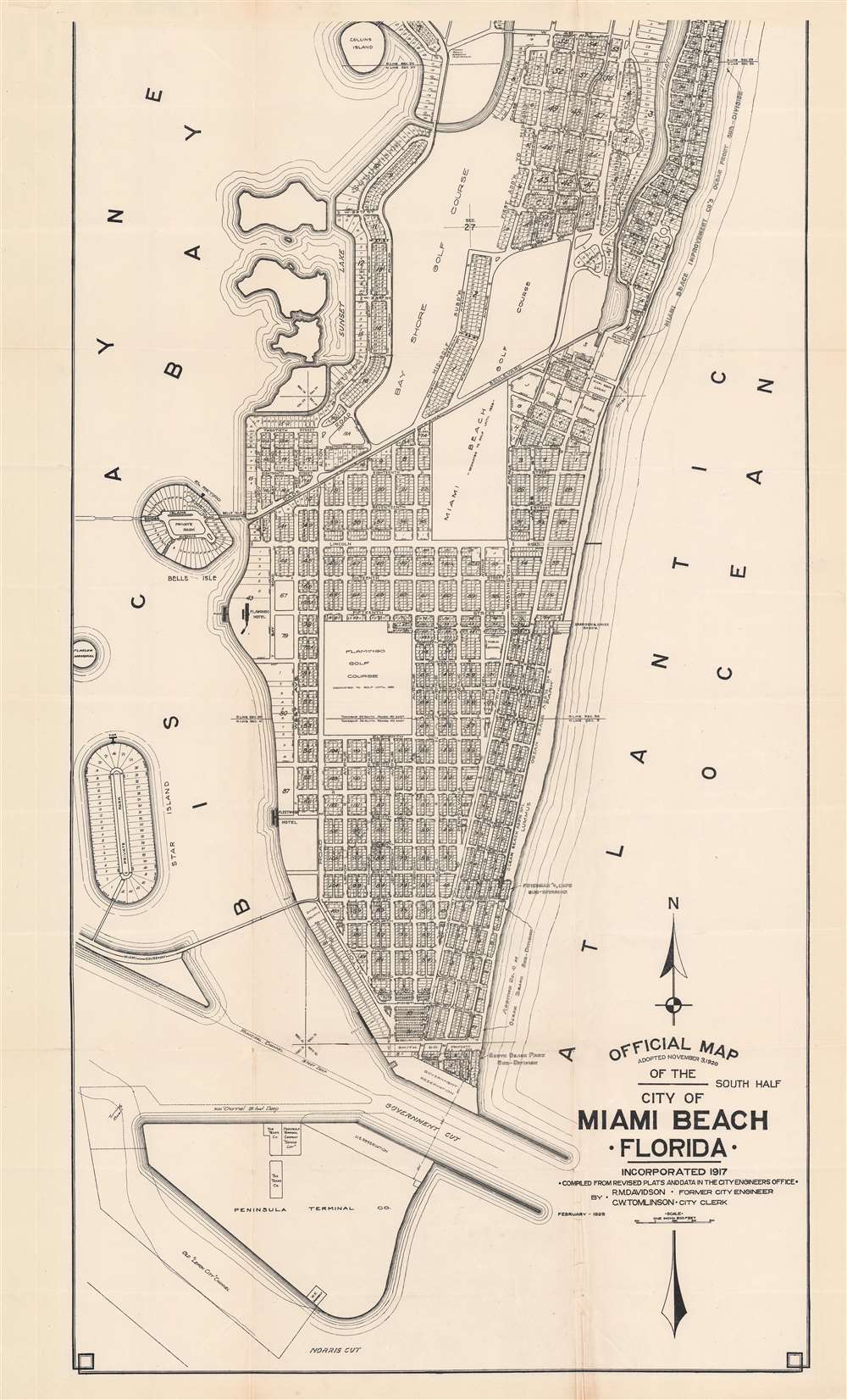
1925 Davidson First Official Map of Miami Beach (south part)
MiamiBeach-davidson-1925$4,750.00

Title
Official Map Adopted November 3, 1920 of the city of Miami Beach Florida.
1925 (dated) 37.75 x 22.75 in (95.885 x 57.785 cm) 1 : 7200
1925 (dated) 37.75 x 22.75 in (95.885 x 57.785 cm) 1 : 7200
Description
This is Robert M. Davidson's 1925 map of Miami Beach, Florida - the earliest known example of the first official planning map of Miami Beach, drawn at the height of construction in Miami Beach and the apex of the Florida Land Boom. The map was first drawn by Davidson, Miami Beach's first City Engineer, in 1920, with the present example bearing the date of February 1925. The map covers from 42nd Street to South Point, covering modern day South Beach and parts of Mid-Beach. The map reveals the early planning and lotting of Miami Beach, noting sub-divisions, individual lots, parks, hotels, and golf clubs, and elite developments such as 'Star Island'. Although very large as is, the present map is only the 'South Half' of the full map, although no surviving examples of the 'North Half' are known, and it may not have been issued at all.
Miami Beach
In 1900 Miami Beach was part of the John S. Collins (1837 - 1928) avocado plantation. Collins understood the potential of the barrier islands as a resort hub, but the farmlands, tangled mangrove swamps, and general inaccessibility stood in the way of serious development. Nonetheless, with help from venture capitalists, Collins persisted, in 1913 constructing a 2.5-mile wooden bridge, the Collins Bridge - at the time the world's longest - connecting Miami to Miami Beach. Collins, and his fellow investors Carl G. Fisher (1874 - 1939), and the Lummus brothers, build elegant mansions on the island. Miami Beach was incorporated as a town in 1915, and then as a city (as here), in 1917. This began the Miami Beach building rush and the Florida Land Boom in general. The overall layout of Miami Beach was determined by Robert M. Davidson, the city's first official civil engineer, using a preliminary (likely manuscript) version of this very map. The first grand hotels, the Flamingo Hotel (1923) and the Fleetwood Hotel (1924), were constructed and appear here. Construction in Miami Beach reached its apex in 1925, the year this map was issued.Publication History and Census
This map was drawn by Robert Mitchell Davidson during his tenure as City Engineer of Miami Beach. The title states that the plan was drawn and 'adopted' on November 3, 1920, but the present example bears a secondary date of February 1925. Davidson is named on the map as 'Former City Engineer', suggesting that this map was rushed to publication by City Clerk Clarence Walter Tomlinson, just as Davidson was stepping down as City Engineer to become the City Manager of nearby Coral Gables. While a manuscript version of this map was no doubt produced and maintained by Davidson, there is no clear indication that this map was published until the present 1925 example. Nor is there any clear evidence that the northern sheet was produced at all. There are 4 maps of the same or similar titles appearing in the OCLC from 1947 through 1999, but upon close examination, the scale, proportions, and other indicators suggest these are completely different maps. Rare. Only known example.CartographerS
Robert Mitchell Davidson (March 27, 1893 - September 3, 1970) was an American civil engineer and real estate broker active in Florida throughout the 20th century. Davidson was born in Wartrace, Tennessee and studied at Vanderbilt University, graduating in 1915 with a degree in civil engineering - just in time to fight in World War I (1914 - 1918). After his service, he relocated to southern Florida, where in 1917 he became the first city engineer of Miami Beach, Florida - at the time undergoing the initial stages large-scale urban planning and construction. He held the position for seven years, from the city's incorporation in 1917 to 1925, overseeing Miami Beach's growth from an idyllic island paradise into a major seaside metropolis. In 1925 he took a position as the first city manager of Coral Gables. In 1930, he returned to Miami Beach where for 17 years he was a real estate broker - capitalizing on the Florida Land Boom. From 1950 until his death in 1970, he was a partner in the firm Read-Martin-Davidson. Davidson was also known for his 'lightning fast' tennis game. More by this mapmaker...
Clarence Walter Tomlinson (March 23, 1888 - October 5, 1955) was an American civil servant and city administrator active in Miami Beach, Florida, in the early to mid-20th century. Tomlinson was born in Wichita, Kansas. After living briefly in Chicago, he relocated to Florida in 1907 to take a position as a timekeeper on the Florida East Coast Railway's 'overseas' extension to Key West. He returned briefly to Chicago, but was once again drawn to Florida in 1919 to work for his former manager at the FEC, W. E. Brown. Brown was involved with the efforts to develop Miami Beach. On August 4, 1920, Tomlinson took a position as assistant City Clerk under J. F. Canova. Later in the same year, he was elected to the position of City Clerk. He remained in this position for the next 35 years, until shortly before his death. Learn More...
Condition
Very good. Slight overall toning. Some wear and light verso reinforcement at a few fold intersections.