This item has been sold, but you can get on the Waitlist to be notified if another example becomes available, or purchase a digital scan.
1920 Love / Murray Official Planning Map of Miami, Florida
MiamiOfficialPlat-love-1920$3,750.00


Title
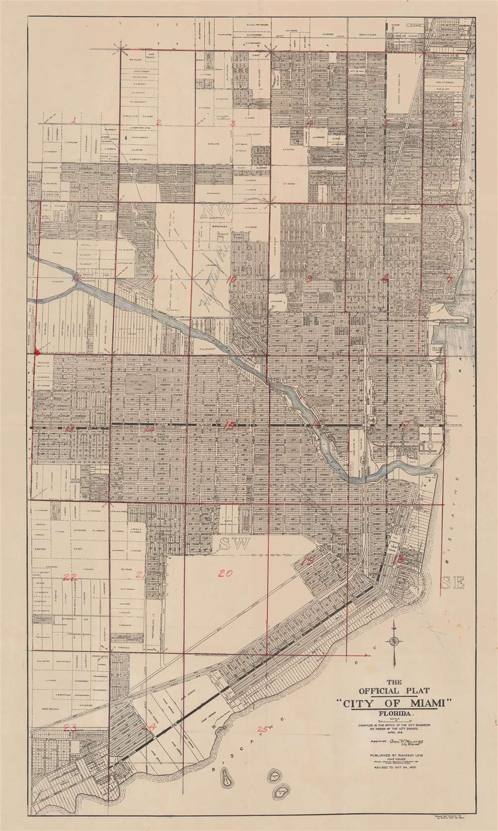
The Official Plat 'City of Miami' Florida.
1920 (dated) 30 x 19 in (76.2 x 48.26 cm) 1 : 10500
1920 (dated) 30 x 19 in (76.2 x 48.26 cm) 1 : 10500
Description
This is the 1920 second edition of the first official plat map of Miami, published at the height of its development during the Third Florida Land Boom. The map lays out the streets and development of Miami from roughly Northeast 39th Street to Kloeber Bay Fronts and illustrates streets, parks, private property holdings, hotels, utilities and more. It exhibits additional manuscript work dividing the city into 25 zones, as well as identifying Highland Park and the home of someone named 'Mary Louise' on SW Fourth St.
Florida Land Booms
In the second half of the 19th and throughout the early 20th century, Florida experienced a series of land booms and crashes. The first followed the Second Seminole War (1835 - 1842), when the government offered homesteaders who agreed to stay five years 160 acres of free land. The second follows the arrival of the railroads to central Florida, leading to nearly 15 years of prosperity and economic growth - mostly revolving around the booming citrus industry. New settlements sprang up throughout the northern half of the state, many owned by absentee investors who never personally visited Florida. The boom collapsed in 1894-95 when a series of historic freezes wiped out the citrus harvest. Property depreciation following the freezes allowed Henry Flagler (1830 - 1913) to develop the Florida East Coast Railway. This, and the arrival of the highway system in the 1920s, led to the third Florida land boom from 1920 to the stock-market crash of 1929.Publication History and Census
The map was originally compiled by Charles Warren Murray, city engineer, and published by the city in 1918. The map was subsequently revised by Richeson Love, Warren's successor as City Engineer, in 1920 - as here. Our records suggest this would make it the 2nd or 3rd published map of Miami. We note the unpublished manuscript Knowlton map of 1896 and the 1918 first edition of the present map. (In addition, Sanborn issued three insurance maps.) Scarce.CartographerS
Walter Richeson Love (April 28, 1887 - August 23, 1937), who went by his middle name, was a civil engineer, surveyor, and map publisher active in Miami c. 1920. Love was born in Knoxville, Tennessee. He was active in Miami from at least 1915, when he was employed by Frederick S. Morse (1859 - 1920) as a commercial surveyor at the Model Land Company. He served in World War I (1914 - 1918), returning to Miami after the war. In 1920, he updated the 1918 Official Plat of Miami to reflect the city's rapid development. In 1922, he owned a commercial map shop in downtown Miami. He was a member of the American Association of Engineers and the Miami Engineering Society. He later took work with Alcoa Aluminum and returned to Knoxville, where he died in 1919 at age 50. More by this mapmaker...
Charles Warren Murray (April 10, 1892 - July 29, 1931) was the City Engineer of Miami in 1918. Murray was born in Jefferson County, Kentucky. He begins appearing in Miami directories in 1918, where he is identified as the City Engineer. In 1918, under this office, he compiled the first official plat of Miami. He subsequently served U.S. Army during World War I (1914 - 1918) from 1918 to 1919. After the war he returned to Miami where he worked for the public welfare office. He died in Miami of 'lingering illness', likely malaria, in 1931. Learn More...
Condition
Very good. Some manuscript updates and annotations. Wear on old fold lines. Light foxing.
References
Boston Public Library, G3934.M5G46 1918 .M53.