This item has been sold, but you can get on the Waitlist to be notified if another example becomes available.
1960 Garris / Connell Diazotype Cadastral Map of Miami Springs, Florida
MiamiSprings-garris-1956$1,100.00


Title
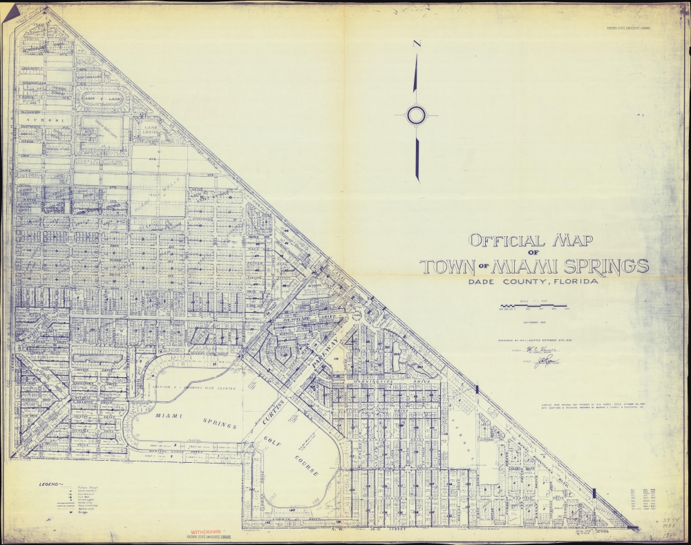
Official Map of Town of Miami Springs Dade County, Florida.
1956 (dated) 41.25 x 52.25 in (104.775 x 132.715 cm) 1 : 3600
1956 (dated) 41.25 x 52.25 in (104.775 x 132.715 cm) 1 : 3600
Description
A large-format 1960 diazotype cadastral map of Miami Springs, Florida, based on an earlier 1950 map by Milton B. Garris, modified and updated by Connell and Associates. It demonstrates the postwar growth of Miami Springs, building on its foundation as a planned community with close connections to the aviation industry.
A Closer Look
Coverage embraces Miami Springs, bordered by the Miami Canal at the northeast and the Florida East Coast Railway and a canal owned by the railway on the west. Immediately south of Miami Springs was an airport known initially as Miami City or Miami Municipal Airport, the basis for today's Miami International Airport. The city is also bisected by the South Side Canal, running northeast-southwest. Lots and tracts are traced and numbered throughout. The Miami Springs Golf Course, which takes up much of the southern portion of the city, is still in operation.Postwar Population Boom
Miami Springs' population quintupled between 1940 and 1950 and doubled again by 1960. Signs of Miami Springs' tremendous postwar growth are evident throughout, such as the designation of 'future streets' in the legend, along with unnamed and yet-to-be-built schools at top-left (now Springview Elementary School) and bottom-right (now Miami Springs Middle School). A dedicated 'Miami Springs Elementary School Site' sits at center (Miami Springs Senior High School was later built on Dove Ave on the lots numbered 61 and 62 here).Aviation City
The history of Miami Springs has always been closely tied to aviation. It was founded as a planned community by aviation pioneer Glenn Curtiss (1878 - 1930), who was heavily invested in real estate during the 1920s Florida Land Boom. The golf course prominent at bottom was a hallmark of the new community, as were its neat, tree-lined streets and distinctive architectural style, discussed below. In 1928, the Miami Municipal Airport opened next to Miami Springs, cementing the close relationship between the city and aviation. In the postwar period, Miami Springs transitioned from a posh and relatively small country club community to a larger and somewhat more typical South Florida suburb, with a large seasonal population.Pueblo Revival Style Architecture
Multiple buildings in Miami Springs are admired for their distinctive Pueblo Revival architectural style, including the mansions of Glenn Curtiss, his mother, Lua Curtiss, and his half-brother and business partner, George Carl Adams. In fact, many of these structures were built by Curtiss and Bright, Glenn Curtiss' own real estate company. Some public buildings, such as the Fair Haven Nursing Home, previously the Miami Sanitorium, were also built in the Pueblo Revival style. Many of these distinctive buildings fell into disrepair in the late 20th century, but concerted efforts have led to their being designated as historically protected, with donors contributing to restoration efforts.Diazo Print or Whiteprint
The diazo print (whiteprint or diazo for short) is a photo reproductive technique best understood as a reverse cyanotype or blueprint. The process yields distinctive blue lines on white paper. Like cyanotypes, the diazo process gained popularity in architecture circles, where it was a simple and effective way to duplicate documents in the field. The earliest diazotypes appeared around 1880 and were adopted for military and field cartographic use from about 1895. The diazo process was commercialized in 1923, when the German firm, Kalle and Company, developed Ozalid, a patented diazo paper that made diazotyping even easier. By the 1950s, it supplemented cyanotypes as the reprographic technique of choice for technical drawings.Publication History and Census
This map was originally drawn by Milton B. Garris in 1950, and thereafter updated regularly by Connell and Associates, with revisions to December 1960. Its provenance, having been deaccessioned from the Arizona State University Library, is clear from stamps and writing on the recto and verso. The map is quite rare, with the only other known example, Garris' 1950 manuscript, being held by Pennsylvania State University.CartographerS
Milton B. Garris (c. 1897 - 1960), also sometimes as 'William B. Garris,' was a land surveyor and civil engineer based in Miami, Florida. He was born in South Carolina and is recorded as having attended the Citadel military college in Charleston, graduating in 1909. Afterwards, he relocated to Florida while working for the U.S. Army Corps of Engineers, where he oversaw dredging and other work in Miami Harbor and adjacent channels. He appears to have ended his military service around 1920 and was consulted for the Sewell Plan and other work in Miami Harbor. He founded Watson and Garris Civil Engineers, Inc. in 1923 with P. L. Watson and notably oversaw the platting of Biscayne Island (Key Biscayne ) on the Venetian Causeway in Miami in 1936. Although his business was located in Miami, Garris resided in nearby Coral Gables, where he ran for City Council in the late 1920s and served as assistant city manager in the late 1940s. He also served as the director of the Miami section of the American Society of Civil Engineers. More by this mapmaker...
Maurice H. Connell (fl. c. 1927 - 1967) was an architect based in Miami, Florida, and the founder of Maurice H. Connell and Associates. The firm was best known for its work with the National Aeronautics and Space Administration (NASA), designing launch facilities and other structures for the Redstone and Saturn rocket programs, including Cape Canaveral Launch Complex 34 at Cape Canaveral. Learn More...
Condition
Very good. Light wear along original folds. Some small tears on edges professionally repaired. Text on verso.
References
OCLC 1026418914.