This item has been sold, but you can get on the Waitlist to be notified if another example becomes available, or purchase a digital scan.
1846 Bradford Map of Michigan
Michigan-bradford-1846$200.00

Title
Michigan.
1846 (dated) 15 x 12 in (38.1 x 30.48 cm) 1 : 1600000
1846 (dated) 15 x 12 in (38.1 x 30.48 cm) 1 : 1600000
Description
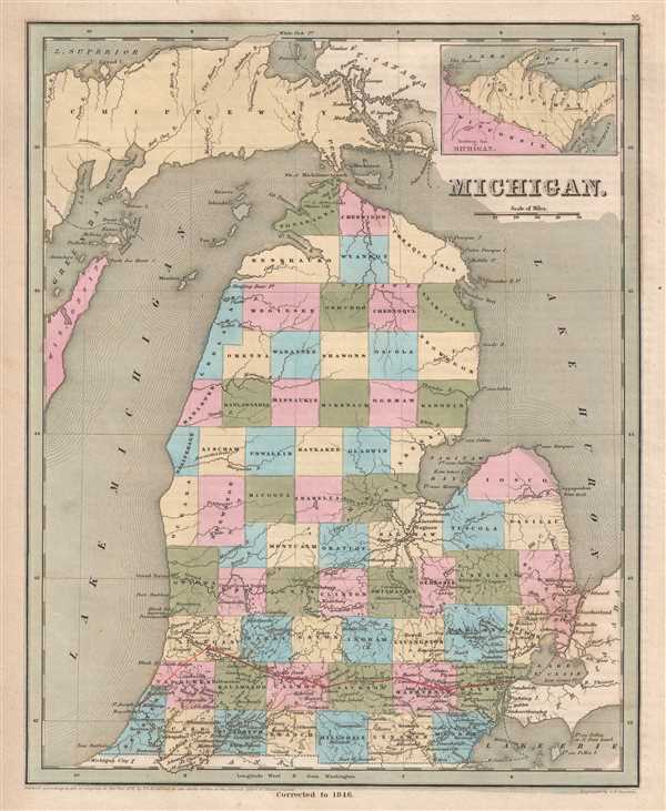
This is an 1846 Thomas G. Bradford map of Michigan. The map depicts the region from Lake Superior, Green Bay, and Wisconsin to Lake Huron and from Lake Superior to Indiana and Lake Erie. Significantly updated from the 1838 edition created eight years earlier, here the Lower Peninsula is entirely divided into counties, whereas in 1838 the northern half of the peninsula was illustrated as being one large county, just as the Upper Peninsula is here. The Michigan Central Railroad, incorporated in 1846, is highlighted in manuscript red ink. The manuscript addition continues further than the original imprint, which only depicted the trackage extending to Allegan. Originally chartered in 1831 as the Detroit and St. Joseph Railroad, the organization quickly ran into financial difficulties. The state government bailed out the railroad in 1837, renaming it the Central Railroad of Michigan. The state then sold the railroad to the newly incorporated Michigan Central corporation in 1846, which operated the railroad independently until 1867 when it was acquired by the New York Central Railroad.
Highly detailed, each county is illustrated, labeled, and shaded a different color to allow for easy differentiation. Numerous cities and towns are labeled, including Detroit and Ann Arbor (Ann Arbour). Myriad rivers and lakes are illustrated, some of which are labeled while others are not. An inset map, entitled 'Northwest Part of Michigan' is situated in the upper right corner and depicts the western part of the Upper Peninsula and northeastern Wisconsin.
This map was engraved by George Boynton and published in the 1846 edition of Bradford and Goodrich's A Universal Illustrated Atlas.
CartographerS
Thomas Gamaliel Bradford (1802 - 1887) was born in Boston, Massachusetts, where he worked as an assistant editor for the Encyclopedia Americana. Bradford's first major cartographic work was his revision and subsequent republishing of an important French geography by Adrian Balbi, Abrege de Geographie published in America as Atlas Designed to Illustrate the Abridgment of Universal Geography, Modern and Ancient. Afterwards Bradford revised and expanded this work into his own important contributions to American cartography, the 1838 An Illustrated Atlas Geographical, Statistical and Historical of the United States and Adjacent Countries. Bradford's cartographic work is significant as among the first to record Texas as an independent nation. In his long career as a map publisher Bradford worked with William Davis Ticknor of Boston, Freeman Hunt of New York, Charles De Silver of Philadelphia, John Hinton, George Washington Boynton, and others. We have been able to discover little of Bradford's personal life. More by this mapmaker...
George Washington Boynton (fl. c. 1830 - 1850) was a Boston based cartographer and map engraver active in the first half of the 19th century. Boynton engraved and compiled maps for numerous publishers including Thomas Bradford, Nathaniel Dearborn, Daniel Adams, and S. G. Goodrich. His most significant work is most likely his engraving of various maps for Bradford's Illustrated Atlas, Geographical, Statistical, and Historical, of the United States and the Adjacent Countries and Universal Illustrated Atlas. He also engraved for the Boston Almanac. In 1835, Boynton is listed as an employee of the Boston Bewick Company, an engraving, stereotype, and printing concern based at no. 47 Court Street, Boston. Little else is known of his life. Learn More...
Source
Bradford, T. G. and Goodrich, S. G., A Universal Illustrated Atlas, exhibiting a Geographical, Statistical, and Historical view of the World, (Boston: Charles D. Strong) 1846.
The Universal Illustrated Atlas is one of the great American atlases of the first half of the 19th century. The atlas was first published in 1838 under the imprint of Charles D. Strong. It replaced and superseded Bradford's earlier smaller format Illustrated Atlas, Geographical, Statistical, and Historical, of the United States and the Adjacent Countries. Numerous reissues of the Universal Illustrated Atlas followed until about 1848. Although there are minor variations between the editions, most contain about 50 maps, the majority of which focus on the United States. Bradford's atlases are significant for recording North America during the Republic of Texas Era. In later editions, particularly the 1846 edition, Bradford illustrates the boom in railroad construction, possibly with the idea that his maps would aid travelers in planning journeys by rail. It was compiled by Thomas Gamaliel Bradford and Samuel Griswold Goodrich with most of the plates engraved by George Washington Boynton (fl. c. 1830 - 1850). Other contributors include Thomas Gordon (1778 - 1848), Fielding Lucas Jr. (1781 - 1854), Samuel Edward Stiles (1844 - 1901), Sherman and Smith (fl. c. 1829 - 1855), and Horace Thayer (1811 - c. 1874).
Condition
Very good. Even overall toning. Blank on verso.
References
Rumsey 0089.021 (1838 edition).