1868 Farmer's Railroad and Township Map of Michigan
Michigan-farmer-1868-2$2,000.00


Title
Farmer's Railroad and Township Map of Michigan and Chart of the Lakes.
1868 (dated) 31.5 x 24.5 in (80.01 x 62.23 cm) 1 : 1140480
1868 (dated) 31.5 x 24.5 in (80.01 x 62.23 cm) 1 : 1140480
Description
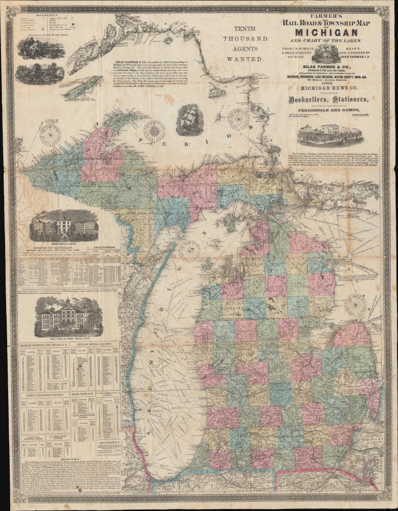
This is an 1868 Silas Farmer railroad and township map of Michigan. Farmer's map appeared during a period when Michigan was a hotspot for emigration and settlement. Both father John Farmer and his son Silas Farmer worked assiduously to keep their maps updated, publishing editions annually and sometimes biannually. Such maps were essential for emigrants not only for travel, but also for planning their new life.
A Closer Look
The map embraces all of modern-day Michigan along with parts of Lake Superior and Lake Huron. The state is divided into counties and surrounded by historical data and statistics likely to be of interest to prospective emigrants. Navigation routes crisscross both Lake Michigan and Lake Huron, with depth soundings and navigation aids in the area's most challenging waters. A breakdown of railways is set in the lower left quadrant: lists of stations and distances are provided for each. Census statistics by county from 1840 - 1860 are located at left center. Other information provided includes a discussion of the history and meaning of Michigan's name, and the state's salt, mining, and mineral industries. There are numerous inset vignettes including a sailing ship in Lake Superior, surveyors and farmers in the upper left, the Lansing Reform School, the Flint Deaf Dumb and Blind Asylum, and the University of Michigan at Ann Arbor.Publication History and Census
This map was created and published by Silas Farmer and Company in 1868. The map is based on an earlier map engraved by Silas' father, John Farmer prior to his death in 1859. All editions of Farmer's maps are sought after by collectors and are scarcely encountered on the market today.CartographerS
John Farmer (February 9, 1798 - March 24, 1859) was an American cartographer based in Detroit, Michigan, in the first half of the 19th century. Farmer was born in the town of Half Moon, Saratoga County, New York where he trained to become a school teacher, mastering, among other academic skills, drafting. At the time, Michigan Territory has a shortage of school teachers and, in 1821, recruited Farmer to head the Lancasterian School in Detroit. Farmer supplemented his salary by using his drafting skills to copy manuscript surveys for new settlers arriving in Michigan. This work must have brought him to the attention government officials, who employed him to compile and draft a map of Michigan's first federally funded road. In 1826, he also published, along with Orange Risdon, one of the earliest maps of Michigan. Working in the 1830s, Farmer taught himself engraving in order to issue a second, more detailed map focusing on the southern half of Michigan's lower peninsula. In 1835, he issued an important general map of the Territories of Michigan and Wisconsin, which became one of his most enduring maps, going the various editions for nearly 25 years. Most of his early map plates he sold to J. H. Colton, who republished them under his own name and imprint. In 1844, Farmer issued State of Michigan and the Surrounding Country, the map that most defined his career. It became the essential Michigan map, indispensable for anyone planning to emigrate to Michigan, do business, or even move about the state. He updated and revised this map throughout the remainder of his life. He also issued a rare wall map of Michigan measuring 5 x 6 ft. After his death, in March of 1859, following a long mental decline, the Farmer map plates passed to his widow Rachel, and sons, Silas, Arthur, and John, who continued the business under Farmer's imprint. More by this mapmaker...
Silas Farmer (June 6, 1839 - December 28, 1902) was an American publisher, historian, and author, and son of the famous cartographer John Farmer. Silas began his career working with his father in the family publishing firm, and continued working for the firm after his father's death. Silas published at least three histories of Detroit, Michigan, entitled The History of Detroit and Michigan (1884), All About Detroit (1899), Guide and Souvenir of Detroit (1891). He died suddenly on December 28, 1902 of an apparent heart attack. Silas married Orpha C. Littlefield in 1868. Learn More...
Condition
Average. Area of infill upper left corner. Some slight loss at fold intersections.
Wear and toning on original fold lines.
References
OCLC 31717435.