This item has been sold, but you can get on the Waitlist to be notified if another example becomes available, or purchase a digital scan.
1878 Rand McNally Railroad Map of the Michigan Central Railroad (Midwest and Northeast United States
MichiganCentralRR-randmcnally-1878$237.50

Title
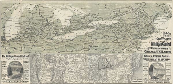
Bird's Eye View of the Country Traversed by the Michigan Central Railroad and its Connections between Chicago and the Atlantic.
1878 (dated on verso) 14.5 x 30 in (36.83 x 76.2 cm) 1 : 1900000
1878 (dated on verso) 14.5 x 30 in (36.83 x 76.2 cm) 1 : 1900000
Description
This is beautiful 1878 railroad map or bird's eye-view map of the Northeast and the Midwestern United States, depicting the Michigan Central Railroad, printed by Rand McNally and Company. This relic of the great age of American Railroads, covers the states of Maine, Vermont, New Hampshire, New York, Connecticut, New Jersey, Pennsylvania, Michigan, Ohio and Indiana. It shows the various connections of the Michigan Central Railway. Important cities are identified throughout, including Detroit, St. Joseph, New York, Chicago, Bay City, Toledo, Pittsburg, Buffalo, Jersey City, among several others.
The Michigan Central Railroad was originally conceptualized in 1830 to provide freight service between Detroit and St. Joseph, Michigan. After overcoming several financial hurdles, and changing ownership from a state owned to a private enterprise, the railroad eventually extended beyond the original end point of St. Joseph to Chicago, Illinois in 1852. By 1871, Michigan Central would run passenger trains and would eventually extend through south western Ontario, Canada, to Buffalo, New York.
The bottom half of the sheet includes a map of the United States, entitled, 'Across the Continent via the Michigan Central Railroad.' The lower left and right quadrants include advertisements for the various attractions along the way. Verso also includes several advertisements. This map was printed by Rand McNally and Company in 1878 to promote the Michigan Central Railroad's passager service.
Cartographer
Rand, McNally and Co. (fl. 1856 - present) is an American publisher of maps, atlases and globes. The company was founded in 1856 when William H. Rand, a native of Quincy, Massachusetts, opened a print shop in Chicago. Rand hired the recent Irish immigrant Andrew McNally to assist in the shop giving him a wage of 9 USD per week. The duo landed several important contracts, including the Tribune's (later renamed the Chicago Tribune) printing operation. In 1872, Rand McNally produced its first map, a railroad guide, using a new cost effective printing technique known as wax process engraving. As Chicago developed as a railway hub, the Rand firm, now incorporated as Rand McNally, began producing a wide array of railroad maps and guides. Over time, the firm expanded into atlases, globes, educational material, and general literature. By embracing the wax engraving process, Rand McNally was able to dominate the map and atlas market, pushing more traditional American lithographic publishers like Colton, Johnson, and Mitchell out of business. Eventually Rand McNally opened an annex office in New York City headed by Caleb S. Hammond, whose name is today synonymous with maps and atlases, and who later started his own map company, C. S. Hammond & Co. Both firms remain in business. More by this mapmaker...
Condition
Very good. Some wear along original fold lines. Minor damage upper left quadrant. Professionally flattened and backed with archival tissue.