This item has been sold, but you can get on the Waitlist to be notified if another example becomes available, or purchase a digital scan.
1833 S.D.U.K. Map of Michigan and Wisconsin (w/ Lake Michigan)
MichiganTerritory-sduk-1833$100.00

Title
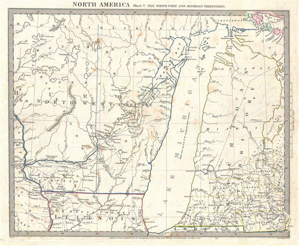
North America Sheet V The North West and Michigan Territories.
1833 (undated) 13 x 16 in (33.02 x 40.64 cm) 1 : 1770000
1833 (undated) 13 x 16 in (33.02 x 40.64 cm) 1 : 1770000
Description
This is a scarce and important map issued by the S.D.U.K. in 1833 depicting Lake Michigan, the second largest of the five Great Lakes, and the only one that lies entirely within the United States. Centered on Lake Michigan, it covers the surrounding region including the states of Michigan and Wisconsin. The map covers the Huron or Northwest Territory (modern day Wisconsin) and the Michigan Territory (modern day Michigan) along with parts of northern Illinois. The map depicts territories and counties in outline color. Lake Michigan is slightly malformed and distended on the vertical axis. The map names several Indian tribes, including the Ottawa and the Chippeway. The Bad Axe River is also identified. It was near the mouth of the Bad Axe River that the Bad Axe Massacre or the Battle of Bad Axe was fought at the end of the Black Hawk War in 1832, one year before this map was issued.
The Black Hawk War was a battle fought between the United States state militia and the Native American tribes Sauk and Fox. The leader of the Native American tribes was a Sauk warrior Black Hawk, who hoped to resettle on the land that was ceded to the United States in a disputed 1804 treaty. The Bad Axe Massacre took place as an aftermath to the Battle of Wisconsin. In this historic last stand, a mere 60 Sauk warriors held off over 700 U.S. regulars and militia under the command of Henry Dodge while the Indian women and children crossed the river to safety. At dawn the Sauk chief Neapope, concealed in a tree, verbally offered to negotiate surrender. The U.S. soldiers, lacking an interpreter, ignored his plea. Fleeing the aftermath of the Battle of Wisconsin Heights the remaining Sauk, mostly women and children, were cornered near the mouth of Bad Axe River and slaughtered. The war is most remembered for giving young Abraham Lincoln his brief military service.
Published in 1833 by Charles Knight of 22 Ludgate Street for the Society for the Diffusion of Useful Knowledge, or S.D.U.K. Although the Society formally closed its doors in 1848, subsequent reissues of the S.D.U.K. atlas were printed well into the 1870s by Chapman and Hall, who acquired the original plates.
CartographerS
The "Society for the Diffusion of Useful Knowledge" (1826 - 1848) was a Whiggish organization founded in 1828 at the instigation of idealistic British lord Henry Peter Brougham. The admirable goal of the Society was to distribute useful information via a series of publications to the English working and middle classes. It promoted self-education and the egalitarian sharing of all knowledge. While closely tied to the London University and publishing houses on the order of Baldwin and Cradock, Chapman and Hall, and Charles Knight, the Society failed to achieve its many lofty goals in finally closed its doors in 1848. Most likely the failure of the Society resulted from its publications being too expensive for its intended lower to middle class markets and yet not large and fine enough to appeal to the aristocratic market. Nonetheless, it did manage to publish several extraordinary atlases of impressive detail and sophistication. Their most prominent atlas consisted of some 200 separately issued maps initially published by Baldwin and Cradock and sold by subscription from 1829 to 1844. Afterwards, the Society combined the maps into a single world atlas published under the Chapman and Hall imprint. In its day, this atlas was unprecedented in its quality, scope, and cost effectiveness. Today Society, or S.D.U.K. as it is commonly known, maps are among the most impressive examples of mid-19th century English mass market cartographic publishing available. The S.D.U.K. is especially known for its beautiful and accurately detailed city plans. More by this mapmaker...
Charles Knight (March 15, 1791 - March 9, 1873) was an English map publisher, author, and editor. Knight was born to a known publishing family. His father, a bookseller of Windsor took him as an apprentice. On fulfilling his indenture, Knight proceed to publish several small newspapers, including The Etonian and Knight's Quarterly Magazine. In 1828 Knight has contracted to become the superintendent of the newly formed Society for the Diffusion of Useful Knowledge, or S.K.U.K. for short. Knight's personal values matched those of the S.D.U.K., whose stated purpose was the democratization of knowledge. Most of Knight's cartographic publications were in association with the S.K.U.K., which financed a detailed and comprehensive world atlas. Despite Knights able management, the goals of the S.D.U.K. we're not fiscally supported by the sale of its publication and the organization folded in 1848. Knight however, continued his publishing career as well has his career as an author, producing such works as The Results of Machinery (1831) and Knowledge is Power (1855). He also composed his own autobiography, published in two volumes from 1864 to 1865, entitled Working Life during Half a Century. Knight died in Addlestone, Surrey, in 1873, at a respectable 81 years. Learn More...
Source
Maps of the Society for the Diffusion of Useful Knowledge, (London: Charles Knight), 1833.
Condition
Very good. Original platemark visible. Blank on verso. Minor spotting at places.
References
Rumsey 0890.132. Phillips (Atlases) 794.