
This item below is out of stock, but another example (left) is available. To view the available item, click "Details."
Details
1970 Baynes Map Map of Middle Earth for Tolkien's 'Lord of the Rings'
1970 (dated) $1,200.00
1978 Baynes Map Map of Middle Earth for Tolkien's 'Lord of the Rings'
MiddleEarth-baynes-1978$475.00


Title
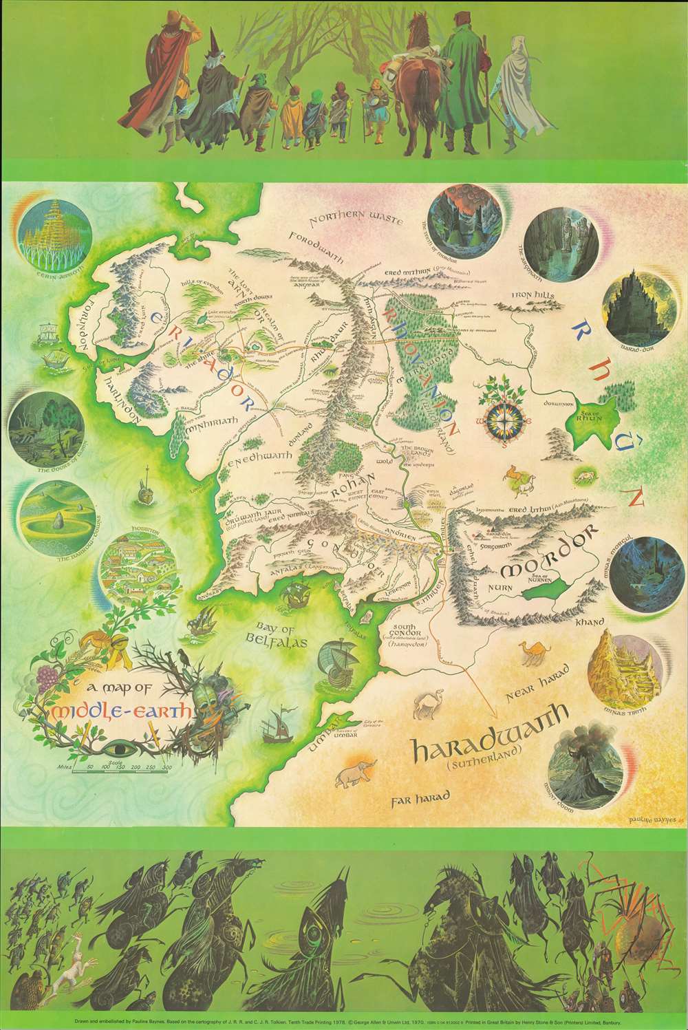
A Map of Middle-Earth.
1978 (dated) 30 x 20 in (76.2 x 50.8 cm)
1978 (dated) 30 x 20 in (76.2 x 50.8 cm)
Description
This is the 1978 edition of the iconic 1970 poster map of J. R. R. Tolkien's Middle Earth drawn by Pauline Diana Baynes to promote the George, Allen and Unwin release of the Lord of the Rings. Tolkien heaped praise upon Baynes' work, saying 'They are more than illustrations, they are a collateral theme. I showed them to my friends whose polite comment was that they reduced my text to a commentary on the drawings.'
Baynes worked closely with Tolkien to complete the map, visiting and corresponding with him extensively - at one point she described him as 'not very helpful.' Later, he was apparently pleased with the map, as Baynes wrote regarding the map's release event, 'He in great form - first names and kissing all round - and pleased with the map.'
The Making of the Map
This map corresponds to the famous map drawn by J. R. R. Tolkien's son, Christopher J. R. Tolkien (1924 - 2020) for issue with The Fellowship of the Ring. With the help of cartographers from the Bordon military camp in Hampshire, Baynes expanded upon the map to create the present production. The header features the heroes of The Fellowship of the Ring marching together towards a dark forest. In the footer, the forces of darkness mount a pursuit - the Nine Nazgûl or Ringwraiths lead, follows on either side by Gollum, orc and human warriors, and the giant spider Shelob. Key locations from the novels appear in vignette form around the map, including Hobbiton and Mount Doom.Baynes worked closely with Tolkien to complete the map, visiting and corresponding with him extensively - at one point she described him as 'not very helpful.' Later, he was apparently pleased with the map, as Baynes wrote regarding the map's release event, 'He in great form - first names and kissing all round - and pleased with the map.'
Publication History and Census
The map was drawn by Pauline Baynes in 1969 and first published in 1970 by George, Allen and Unwin. The posters were initially given out with the first 200 copies of the boxed Lord of the Rings trilogy. The present example is the 10th trade printing, 1978. While widely reproduced, original trade printings with the publisher's imprint at the bottom center, as here, are scarce.Cartographer
Pauline Diana Baynes (September 9, 1922 - August 1, 2008) was an English illustrator and commercial artist. Pauline was born in Hove, Sussex, England and spent her early years in Agra and Mussoorie, India, where her father was a magistrate with the British imperial Indian Civil Service. At age 5, she returned with her mother and sister to England, where she lived a nomadic life - seeing very little of her father thereafter, who remained in India. She studied at the Beaufort School, then at the Farnham School of Art, then at the prestigious Slade School of Fine Art. During World War II she severed with the Women's Voluntary Service at the Camouflage Development Training Centre at Farnham Castle. After the war she submitted several drawing to the publisher George, Allen and Unwin, through which they caught the attention of fantasy novelist J. R. R. Tolkien. Her subsequent collaboration with Tolkien including illustrations for Farmer Giles of Ham, The Adventures of Tom Bombadil, The Hobbit, and The Lord of the Rings, among others, as well as supplementary promotional work, including several maps. Baynes' illustrations for Tolkien's, caught the attention of C. S. Lewis, who contracted her to illustrate for the Chronicles of Narnia. She continued to illustrate for books and novels until she died of ischaemic heart disease at 85. More by this mapmaker...
Condition
Very good.