
This item below is out of stock, but another example (left) is available. To view the available item, click "Details."
Details
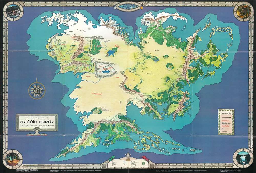
1982 Fenlon Map of J. R. R. Tolkien's Middle Earth (Endor Continent)
$450.00
1982 Fenlon Map of J. R. R. Tolkien's Middle Earth (Endor Continent)
MiddleEarth-fenlon-1982-3$187.50

Title
An Artist's Interpretation of Middle Earth including the Wild Lands - east, south, and north.
1982 (dated) 24.25 x 35.5 in (61.595 x 90.17 cm) 1 : 19000000
1982 (dated) 24.25 x 35.5 in (61.595 x 90.17 cm) 1 : 19000000
Description
This is a 1982 map of J. R. R. Tolkien's fantasy world 'Middle-Earth' by Peter C. Fenlon. Fans of Tolkien will be quick to recognize the northeastern part of the map, generally known as the Westlands, encompassing the main theater of both the Hobbit and The Lord of the Rings. The cartography for these areas, from Forodwaith to Umbar and from the western ocean (Belegaer) to the Sea of Rhûn, is drawn directly from the iconic map that accompanied the The Lord of the Rings. Unlike the maps published in Tolkien's famous books, the present map extends south and west to embrace the entire continent of Endor. Cartographically, Endor roughly mirrors Europe (Westlands), Africa (Haradwraith), and Asia (east of Rhûn). Although Tolkien's Legendarium does in fact give some hints regarding the lands and topography to the east of Mordor and Rhûn, much of the cartography here seems to have been imagined by Fenlon. Nonetheless, this map proved popular in the 1980s and was distributed to complement Iron Crown Enterprises successful LOTR-based role-playing game series. Although the map has no scale, we extrapolated a scale of 1:19000000 based on Tolkien's statement that Mirkwood was 300 miles wide.
Fenlon Describes the Making of this Map
In Mapping Middle-Earth: An Interview with Pete Fenlon, published in the January 1996 Issue 12 of the Middle-Earth fanzine Other Hands, Chris Seeman questions Felon on the making of this map and his sources (pages 37 - 40). Fenlon replies,I had access to a photocopy of a sketch map from a guy from Oxford that later appeared in The Shaping of Middle-earth; that was a pretty important thing to have. Using it as a rough outline, taking into account and weighing the similarities versus the differences with our own world, I started to work on my own rough outline. I think I went through about three of them before I was able to reconcile the rough shape with what I understood to be the migration and weather patterns, extrapolated distances, and the like. So, reconciling all three of those, I came up with the published interpretation, which is based on a reasonably good grounding in geology, weather, and the like. I am a generalist in the strongest sense of the word. These things are highly interrelated; and, in a sense, I tried to apply all that knowledge as best as I could. Then I had to twist it a little bit, given the fact that I was trying to apply it to a globe instead of a flat earth map.Pete goes on, later in the interview, to extrapolate on his invented place names,
I have to confess that was really a matter of simply taking what limited knowledge we have of these regions, and applying it in a broad stroke theme. The only issue I was dealing with there was that of Mannish (or Hildo) versus Elvish groups, assuming that the place names in most areas would have some sort of Hildo origin, and the names in the old Elvish areas might still reflect some connection with the Quendi. Then my main goal was to create names that were evocative, wild, and dissimilar from the sorts of names that you might find in common fantasy.Fenlon's hundreds of place names are apparent throughout this map and thus largely consistent with what we might have expected from Tolkien.
Publication History and Census
There are at least two editions of this map, this being the first. It was printed to accompany A Campaign and Adventure Guidebook for Middle-earth in 1982. Reprints followed in 1983 and later. This map has become increasingly scarce on the market.Cartographer
Pete Fenlon (1955 - present) is an American role-playing game designer, game developer, graphics designer and publisher. His works include stories, art and games (electronic and non) in the genres of science fiction, mystery, fantasy and historical fiction. For the purposes of maps, his best-known work is a large format map of the Tolkienian continent of Endor that extends well beyond the lands covered in The Lord of the Rings and other Tolkien literature. He is also responsible for the popular board and car game, The Settlers of Catan. More by this mapmaker...
Condition
Very good. Exhibits slight wear on original fold lines.
References
Seeman, Chirs, 'Mapping Middle-Earth: An Interview with Pete Fenlon', in Other Hands, Issue 12, January 1997, (ISSN 1081-8359), pages 27-40.