1912 Plat Map of Midfield, Texas
MidfieldTX-lund-1912$400.00

Title
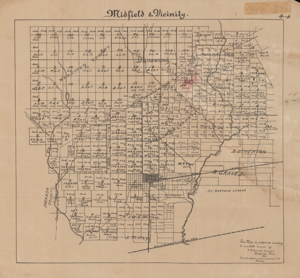
Midfield and Vicinity.
1912 (dated) 15.5 x 17.25 in (39.37 x 43.815 cm) 1 : 63360
1912 (dated) 15.5 x 17.25 in (39.37 x 43.815 cm) 1 : 63360
Description
A rare 1912 plat map of Midfield, Texas and surrounding areas produced by F. P. Lund. Among other features, it reveals the extensive landholdings of the International - Great Northern Railroad, the result of an unrealized plan to connect the town with points further east and north.
A Closer Look
Though focusing on the town of Midfield (also as Midfields, as at bottom-right), coverage extends over large portions of Matagorda and Wharton Counties. Individual landholders are named or at least abbreviated where space permits, along with information on the size of their plots. The town of Midfield sits towards bottom-center. Neighboring counties, rivers, and creeks, are also indicated.Midfield Junction
Two rail lines, the Southern Pacific and St. Louis, Brownsville and Mexico Railway, intersect at bottom. However, much of the land around Midfield, if not an absolute majority in Matagorda County, is owned by the International - Great Northern Railroad. Beginning in Longview, near the Arkansas-Louisiana-Texas border in 1873, the line extended southwards continuously, eventually reaching Austin, San Antonio, and Laredo. It was a prolific landholder throughout Texas, with plans to build extensions and branch lines to its main route. In the early 20th century, the railroad had planned to extend to nearby Bay City, east of Midfield, and presumably on to Midfield itself, but was ruined by the Great Panic of 1907. It was sold in 1908 and reorganized in 1911 with a nearly identical name but was bankrupted again a decade later, never having reached Bay City, let alone Midfield.Publication History and Census
This map was prepared by F.P. Lund in 1912. In addition to surveying work, Midfield resident F.P. Lund appears to have been a professor, agricultural expert, and ardent evangelist who operated a Sunday school, though concrete details of his life and work are elusive. The map is not cataloged among the holdings of any institution and has no known history on the market.Condition
Good. Soiling at right. Adhesive residue and crimped corner in top-right margin.